Property Record
1565 Simmsville Rd, Alabaster, AL 35007
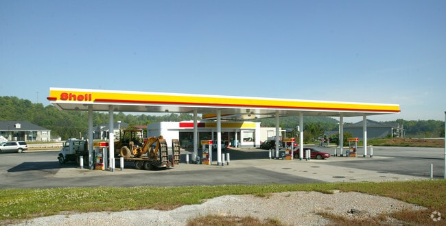

Property Detail
1565 Simmsville Rd
13-7-36-1-001-003-003
COM INT W ROW I-65 & NW ROW CO RD11 SW ALG CO RD 407.99 TO POB; SW129.73 SW103.33 TO N ROW CO RD68 W104 N134.03 NE151.02 SE212.15 TO POB
Conveniencestore
SHELBY
B and X Area of moderate flood hazard, usually the area between the limits of the 100-year and 500-year floods.
Alabama
2024
1.02 AC
2024
I-65 Corr/S Shelby County
030341
Birmingham
2,520 SF
Birmingham, AL
NEARBY LISTINGS FOR SALE OR LEASE
DEMOGRAPHICS near 1565 Simmsville Rd
1 mile
3 mile
5 mile
2025 Total Population
4,528
32,885
66,429
2030 Population
4,674
33,888
68,953
Pop Growth 2025-2030
+ 3.22%
+ 3.05%
+ 3.80%
Average Age
40
40
39
2025 Total Households
1,794
12,237
24,157
HH Growth 2025-2030
+ 3.34%
+ 3.15%
+ 3.85%
Median Household Inc
$72,981
$85,526
$88,470
Avg Household Size
2.50
2.60
2.70
2025 Avg HH Vehicles
2.00
2.00
2.00
Median Home Value
$255,693
$263,289
$274,100
Median Year Built
1997
1993
1995
Nearby Places
Map Layers
Map Styles
 Street
 Aerial
Transit
 Traffic
 Biking
Places
Listings with unknown addresses are not visible on the map
- Restaurants
- Banks
- Shops
- Fitness
- Groceries
PUBLIC TRANSPORTATION
AIRPORT
Birmingham-Shuttlesworth International
Drive
Walk
Distance
Birmingham-Shuttlesworth International
36 min
25.9 mi
Freight Ports
Port of Mobile
Drive
Walk
Distance
Port of Mobile
259 min
236.3 mi
Nearby Properties
Address
Land Use
TOTAL SIZE
Lot Size
Zoning
Address
Land Use
TOTAL SIZE
Lot Size
Zoning
228,107 SF
12 AC
Address
Land Use
TOTAL SIZE
Lot Size
Zoning
2,100 SF
6.50 AC
Address
Land Use
TOTAL SIZE
Lot Size
Zoning
5,574 SF
14.87 AC
Address
Land Use
TOTAL SIZE
Lot Size
Zoning
2,891 SF
18.10 AC
Address
Land Use
TOTAL SIZE
Lot Size
Zoning
3,872 SF
20.35 AC
Address
Land Use
TOTAL SIZE
Lot Size
Zoning
9,444 SF
21.79 AC
Address
Land Use
TOTAL SIZE
Lot Size
Zoning
10,500 SF
21 AC
Address
Land Use
TOTAL SIZE
Lot Size
Zoning
1,763 SF
21.99 AC
Address
Land Use
TOTAL SIZE
Lot Size
Zoning
11,192 SF
26.78 AC
Address
Land Use
TOTAL SIZE
Lot Size
Zoning
118,303 SF
22.89 AC
Address
Land Use
TOTAL SIZE
Lot Size
Zoning
219,975 SF
14.90 AC
Address
Land Use
TOTAL SIZE
Lot Size
Zoning
268,750 SF
9.93 AC
Address
Land Use
TOTAL SIZE
Lot Size
Zoning
62,398 SF
11.51 AC
Address
Land Use
TOTAL SIZE
Lot Size
Zoning
84,355 SF
15.65 AC
Address
Land Use
TOTAL SIZE
Lot Size
Zoning
43,419 SF
7.81 AC
Address
Land Use
TOTAL SIZE
Lot Size
Zoning
126,897 SF
9.43 AC
Address
Land Use
TOTAL SIZE
Lot Size
Zoning
46,031 SF
9.86 AC
Address
Land Use
TOTAL SIZE
Lot Size
Zoning
6,864 SF
6.11 AC
Address
Land Use
TOTAL SIZE
Lot Size
Zoning
30,158 SF
8.35 AC
Address
Land Use
TOTAL SIZE
Lot Size
Zoning
137,068 SF
9.08 AC
Address
Land Use
TOTAL SIZE
Lot Size
Zoning
54,297 SF
41 AC
Address
Land Use
TOTAL SIZE
Lot Size
Zoning
3,414 SF
7.03 AC
Address
Land Use
TOTAL SIZE
Lot Size
Zoning
77,365 SF
24.97 AC
Address
Land Use
TOTAL SIZE
Lot Size
Zoning
Address
Land Use
TOTAL SIZE
Lot Size
Zoning
94,901 SF
10.78 AC
Address
Land Use
TOTAL SIZE
Lot Size
Zoning
5,000 SF
43 AC
Address
Land Use
TOTAL SIZE
Lot Size
Zoning
51,264 SF
6.98 AC
Address
Land Use
TOTAL SIZE
Lot Size
Zoning
43,206 SF
6.80 AC
Address
Land Use
TOTAL SIZE
Lot Size
Zoning
41,120 SF
10.24 AC
The World's #1 Commercial Real Estate Marketplace
Connect with us
© 2026 CoStar Group
The information above has been obtained from sources believed reliable. While we do not doubt its accuracy we have not verified it and make no guarantee, warranty or representation about it. It is your responsibility to independently confirm its accuracy and completeness. Any projections, opinions, assumptions, or estimates used are for example only and do not represent the current or future performance of the property. The value of this transaction to you depends on tax and other factors which should be evaluated by your tax, financial, and legal advisors. You and your advisors should conduct a careful, independent investigation of the property to determine to your satisfaction the suitability of the property for your needs.