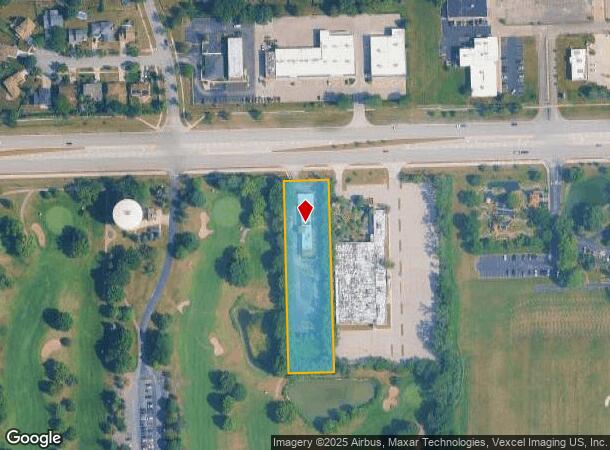
Property Record
1565 75Th St, Woodridge, IL 60517
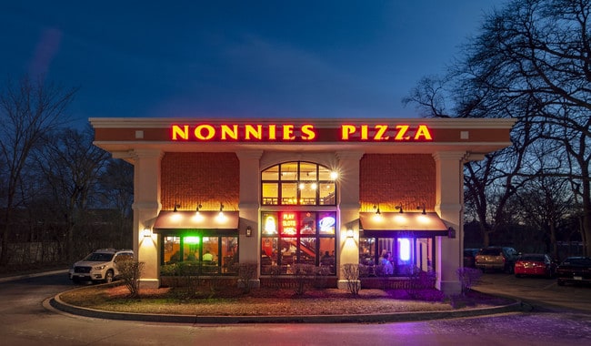
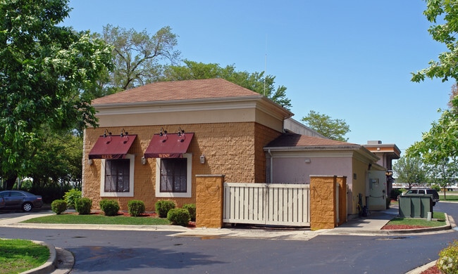

This Property Is For Sale
NEARBY LISTINGS FOR SALE OR LEASE
Property Detail
1565 75Th St
09-30-300-002
W 132 FT E 462 FT N 660 FT SW FL 1/4
Commercialnec
DuPage
X
Illinois
17043C0169J
1.70 AC
2024
Western East/West Corr
2024
Chicago
845809
Chicago-Naperville-Elgin, IL-IN-WI
7,063 SF
DEMOGRAPHICS near 1565 75Th St
1 Mile
3 Mile
5 Mile
2024 Total Population
12,780
99,806
241,212
2029 Population
12,651
98,673
238,477
Pop Growth 2024-2029
(1.01%)
(1.14%)
(1.13%)
Average Age
41
42
42
2024 Total Households
4,891
40,115
94,946
HH Growth 2024-2029
(1.17%)
(1.16%)
(1.18%)
Median Household Inc
$96,607
$93,709
$97,602
Avg Household Size
2.60
2.40
2.50
2024 Avg HH Vehicles
2.00
2.00
2.00
Median Home Value
$378,961
$345,908
$360,148
Median Year Built
1982
1977
1977
Nearby Places
- Restaurants
- Banks
- Shops
- Fitness
- Groceries
PUBLIC TRANSPORTATION
COMMUTER RAIL
Downers Grove Main Street Station (Burlington Northern-Santa Fe Railway Line - Northeast Illinois Regional Commuter Railroad (Metra))
DRIVE
WALK
Distance
Downers Grove Main Street Station (Burlington Northern-Santa Fe Railway Line - Northeast Illinois Regional Commuter Railroad (Metra))
9 min
4.0 mi
Belmont Station (Burlington Northern-Santa Fe Railway Line - Northeast Illinois Regional Commuter Railroad (Metra))
DRIVE
WALK
Distance
Belmont Station (Burlington Northern-Santa Fe Railway Line - Northeast Illinois Regional Commuter Railroad (Metra))
10 min
4.3 mi
AIRPORT
Chicago Midway International
DRIVE
WALK
Distance
Chicago Midway International
26 min
16.7 mi
Chicago O'Hare International
DRIVE
WALK
Distance
Chicago O'Hare International
41 min
26.5 mi
Freight Ports
Port Milwaukee
DRIVE
WALK
Distance
Port Milwaukee
122 min
98.3 mi
Nearby Properties
Address
Land Use
TOTAL SIZE
Lot Size
Zoning
Address
Land Use
TOTAL SIZE
Lot Size
Zoning
12.96 AC
M
Address
Land Use
TOTAL SIZE
Lot Size
Zoning
439,070 SF
38.77 AC
C
Address
Land Use
TOTAL SIZE
Lot Size
Zoning
5.13 AC
M
Address
Land Use
TOTAL SIZE
Lot Size
Zoning
22.17 AC
M
Address
Land Use
TOTAL SIZE
Lot Size
Zoning
21,520 SF
32.67 AC
Address
Land Use
TOTAL SIZE
Lot Size
Zoning
13.53 AC
M
Address
Land Use
TOTAL SIZE
Lot Size
Zoning
21.12 AC
Address
Land Use
TOTAL SIZE
Lot Size
Zoning
18.23 AC
M
Address
Land Use
TOTAL SIZE
Lot Size
Zoning
315,708 SF
21.95 AC
M
Address
Land Use
TOTAL SIZE
Lot Size
Zoning
368,233 SF
16.12 AC
Address
Land Use
TOTAL SIZE
Lot Size
Zoning
19.02 AC
M
Address
Land Use
TOTAL SIZE
Lot Size
Zoning
388,561 SF
12.77 AC
Address
Land Use
TOTAL SIZE
Lot Size
Zoning
8.53 AC
M
Address
Land Use
TOTAL SIZE
Lot Size
Zoning
14.98 AC
M
Address
Land Use
TOTAL SIZE
Lot Size
Zoning
308,196 SF
17.65 AC
M
Address
Land Use
TOTAL SIZE
Lot Size
Zoning
334,656 SF
17.72 AC
I
Address
Land Use
TOTAL SIZE
Lot Size
Zoning
9.58 AC
M
Address
Land Use
TOTAL SIZE
Lot Size
Zoning
353,286 SF
19.84 AC
Address
Land Use
TOTAL SIZE
Lot Size
Zoning
28.89 AC
Address
Land Use
TOTAL SIZE
Lot Size
Zoning
205,315 SF
0.87 AC
Address
Land Use
TOTAL SIZE
Lot Size
Zoning
173,098 SF
16.32 AC
R-6
Address
Land Use
TOTAL SIZE
Lot Size
Zoning
173,459 SF
14.58 AC
C
Address
Land Use
TOTAL SIZE
Lot Size
Zoning
126,165 SF
20.34 AC
Address
Land Use
TOTAL SIZE
Lot Size
Zoning
9.97 AC
M
Address
Land Use
TOTAL SIZE
Lot Size
Zoning
13.42 AC
Address
Land Use
TOTAL SIZE
Lot Size
Zoning
13.46 AC
M
Address
Land Use
TOTAL SIZE
Lot Size
Zoning
268,566 SF
15.24 AC
M
Address
Land Use
TOTAL SIZE
Lot Size
Zoning
314,196 SF
21.08 AC
Address
Land Use
TOTAL SIZE
Lot Size
Zoning
121,968 SF
2.07 AC
Address
Land Use
TOTAL SIZE
Lot Size
Zoning
98,767 SF
3.02 AC
The World's #1 Commercial Real Estate Marketplace
Connect with us
© 2025 CoStar Group
The information above has been obtained from sources believed reliable. While we do not doubt its accuracy we have not verified it and make no guarantee, warranty or representation about it. It is your responsibility to independently confirm its accuracy and completeness. Any projections, opinions, assumptions, or estimates used are for example only and do not represent the current or future performance of the property. The value of this transaction to you depends on tax and other factors which should be evaluated by your tax, financial, and legal advisors. You and your advisors should conduct a careful, independent investigation of the property to determine to your satisfaction the suitability of the property for your needs.