Property Record
15650 Highway 6, Navasota, TX 77868
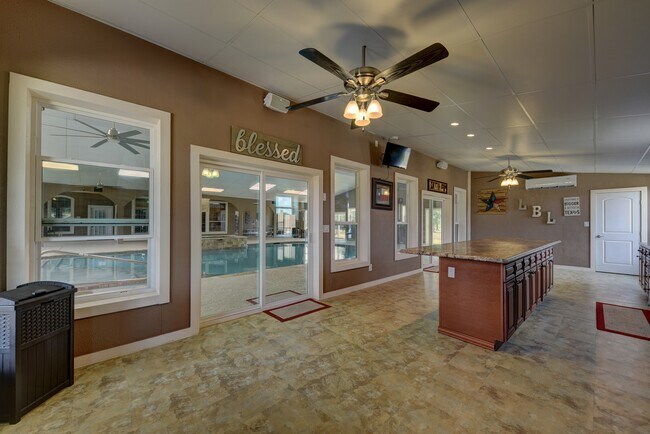

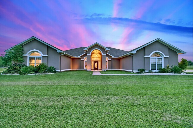
Property Detail
15650 Highway 6
R14849
A0059 J WALLACE, TRACT 40, ACRES 12.01
Ranch
Grimes
1
Texas
A Areas with a 1% annual chance of flooding and a 26% chance of flooding over the life of a 30-year mortgage.
40
2024
12.01 AC
2025
Central Texas Area
180101
Other Market Areas
19,319 SF
NEARBY LISTINGS FOR SALE OR LEASE
-
-
View all Navasota listings for sale on LoopNet.com
DEMOGRAPHICS near 15650 Highway 6
1 mile
3 mile
5 mile
2025 Total Population
95
2,405
4,997
2030 Population
105
2,534
5,317
Pop Growth 2025-2030
+ 10.53%
+ 5.36%
+ 6.40%
Average Age
43
47
46
2025 Total Households
38
302
846
HH Growth 2025-2030
+ 10.53%
+ 10.60%
+ 11.23%
Median Household Inc
$93,749
$74,374
$69,767
Avg Household Size
2.30
2.40
2.50
2025 Avg HH Vehicles
2.00
2.00
2.00
Median Home Value
$210,000
$229,545
$240,604
Median Year Built
2001
1998
1999
Nearby Places
Map Layers
Map Styles
 Street
 Aerial
Transit
 Traffic
 Biking
Places
Listings with unknown addresses are not visible on the map
- Restaurants
- Banks
- Shops
- Fitness
- Groceries
PUBLIC TRANSPORTATION
AIRPORT
Easterwood Field
Drive
Walk
Distance
Easterwood Field
44 min
33.2 mi
Freight Ports
Port of Houston
Drive
Walk
Distance
Port of Houston
92 min
74.2 mi
SALE & LEASE HISTORY
LISTING DATE
SALE/LEASE

Mar 17, 2021
For Sale
Nearby Properties
Address
Land Use
TOTAL SIZE
Lot Size
Zoning
Address
Land Use
TOTAL SIZE
Lot Size
Zoning
923.52 AC
1
Address
Land Use
TOTAL SIZE
Lot Size
Zoning
6,459 SF
349.57 AC
1
Address
Land Use
TOTAL SIZE
Lot Size
Zoning
78,330 SF
25 AC
1
Address
Land Use
TOTAL SIZE
Lot Size
Zoning
87,441 SF
536.10 AC
1
Address
Land Use
TOTAL SIZE
Lot Size
Zoning
20,658 SF
47.46 AC
1
Address
Land Use
TOTAL SIZE
Lot Size
Zoning
118,862 SF
4.53 AC
1
Address
Land Use
TOTAL SIZE
Lot Size
Zoning
44,342 SF
54.65 AC
1
Address
Land Use
TOTAL SIZE
Lot Size
Zoning
17,542 SF
18.07 AC
1
Address
Land Use
TOTAL SIZE
Lot Size
Zoning
8,156 SF
20.35 AC
Address
Land Use
TOTAL SIZE
Lot Size
Zoning
15,717 SF
11.76 AC
1
Address
Land Use
TOTAL SIZE
Lot Size
Zoning
100.48 AC
1
Address
Land Use
TOTAL SIZE
Lot Size
Zoning
4,530 SF
30.04 AC
1C
Address
Land Use
TOTAL SIZE
Lot Size
Zoning
43.51 AC
1
Address
Land Use
TOTAL SIZE
Lot Size
Zoning
1,458 SF
40.99 AC
Address
Land Use
TOTAL SIZE
Lot Size
Zoning
9,523 SF
10.01 AC
Address
Land Use
TOTAL SIZE
Lot Size
Zoning
21,209 SF
77.06 AC
1
Address
Land Use
TOTAL SIZE
Lot Size
Zoning
12,650 SF
58.43 AC
1
Address
Land Use
TOTAL SIZE
Lot Size
Zoning
12,777 SF
29.99 AC
1
Address
Land Use
TOTAL SIZE
Lot Size
Zoning
19,570 SF
443.71 AC
1
Address
Land Use
TOTAL SIZE
Lot Size
Zoning
9,049 SF
36.06 AC
1
Address
Land Use
TOTAL SIZE
Lot Size
Zoning
15,520 SF
50 AC
1
Address
Land Use
TOTAL SIZE
Lot Size
Zoning
47,491 SF
101.43 AC
1
Address
Land Use
TOTAL SIZE
Lot Size
Zoning
8,971 SF
10.01 AC
Address
Land Use
TOTAL SIZE
Lot Size
Zoning
12,158 SF
10.01 AC
Address
Land Use
TOTAL SIZE
Lot Size
Zoning
8,564 SF
12.32 AC
1
Address
Land Use
TOTAL SIZE
Lot Size
Zoning
8,533 SF
11.38 AC
1
Address
Land Use
TOTAL SIZE
Lot Size
Zoning
8,386 SF
10.01 AC
Address
Land Use
TOTAL SIZE
Lot Size
Zoning
16,042 SF
24 AC
Address
Land Use
TOTAL SIZE
Lot Size
Zoning
14,293 SF
37.41 AC
1
The World's #1 Commercial Real Estate Marketplace
Connect with us
© 2026 CoStar Group
The information above has been obtained from sources believed reliable. While we do not doubt its accuracy we have not verified it and make no guarantee, warranty or representation about it. It is your responsibility to independently confirm its accuracy and completeness. Any projections, opinions, assumptions, or estimates used are for example only and do not represent the current or future performance of the property. The value of this transaction to you depends on tax and other factors which should be evaluated by your tax, financial, and legal advisors. You and your advisors should conduct a careful, independent investigation of the property to determine to your satisfaction the suitability of the property for your needs.