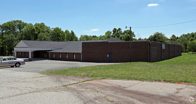
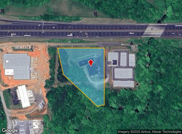
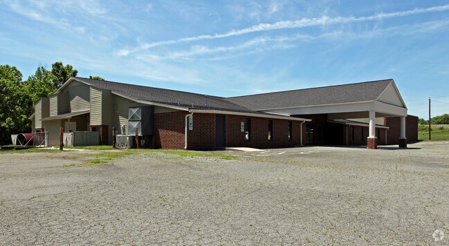
Property Record
1567 Bakatsias Ln, Graham, NC 27253
NEARBY LISTINGS FOR SALE OR LEASE
Property Detail
1567 Bakatsias Ln
Burlington, NC
Final Property John N Bak
152968
BA 1567 BAKATSIAS LANE LT 2 13-14-53
Charitableorganization
Alamance
AE
North Carolina
3710889400K
2
2025
4.85 AC
2025
SE Alamance County
021102
Greensboro/Winston-Salem
22,020 SF
DEMOGRAPHICS near 1567 Bakatsias Ln
1 Mile
3 Mile
5 Mile
2024 Total Population
545
24,153
74,506
2029 Population
597
26,363
80,760
Pop Growth 2024-2029
+ 9.54%
+ 9.15%
+ 8.39%
Average Age
39
39
39
2024 Total Households
215
9,840
29,805
HH Growth 2024-2029
+ 9.77%
+ 9.38%
+ 8.62%
Median Household Inc
$68,035
$52,901
$53,602
Avg Household Size
2.50
2.40
2.40
2024 Avg HH Vehicles
2.00
2.00
2.00
Median Home Value
$191,817
$186,282
$183,293
Median Year Built
1994
1992
1987
Nearby Places
Map Layers
Map Styles
 Street
 Aerial
- Restaurants
- Banks
- Shops
- Fitness
- Groceries
PUBLIC TRANSPORTATION
COMMUTER RAIL
Burlington Station (Piedmont - North Carolina by Train (NC Train))
DRIVE
WALK
Distance
Burlington Station (Piedmont - North Carolina by Train (NC Train))
12 min
6.5 mi
AIRPORT
Piedmont Triad International
DRIVE
WALK
Distance
Piedmont Triad International
54 min
40.6 mi
Raleigh-Durham International
DRIVE
WALK
Distance
Raleigh-Durham International
53 min
41.1 mi
Nearby Properties
Address
Land Use
TOTAL SIZE
Lot Size
Zoning
Address
Land Use
TOTAL SIZE
Lot Size
Zoning
18,778 SF
167.10 AC
R20
Address
Land Use
TOTAL SIZE
Lot Size
Zoning
22,500 SF
100.73 AC
Address
Land Use
TOTAL SIZE
Lot Size
Zoning
919,840 SF
85.58 AC
Address
Land Use
TOTAL SIZE
Lot Size
Zoning
9,728 SF
184.66 AC
M 2
Address
Land Use
TOTAL SIZE
Lot Size
Zoning
159,629 SF
82.81 AC
Address
Land Use
TOTAL SIZE
Lot Size
Zoning
27,803 SF
13.10 AC
B 2
Address
Land Use
TOTAL SIZE
Lot Size
Zoning
578,100 SF
55.30 AC
Address
Land Use
TOTAL SIZE
Lot Size
Zoning
48,136 SF
14.57 AC
B 2
Address
Land Use
TOTAL SIZE
Lot Size
Zoning
27,803 SF
21.86 AC
R20
Address
Land Use
TOTAL SIZE
Lot Size
Zoning
223,391 SF
81.89 AC
R 20
Address
Land Use
TOTAL SIZE
Lot Size
Zoning
198,228 SF
25.26 AC
Address
Land Use
TOTAL SIZE
Lot Size
Zoning
367,187 SF
23.75 AC
M2
Address
Land Use
TOTAL SIZE
Lot Size
Zoning
333,775 SF
46.14 AC
Address
Land Use
TOTAL SIZE
Lot Size
Zoning
37,502 SF
17.48 AC
CR
Address
Land Use
TOTAL SIZE
Lot Size
Zoning
27,803 SF
11.53 AC
Address
Land Use
TOTAL SIZE
Lot Size
Zoning
33,280 SF
9.07 AC
I2
Address
Land Use
TOTAL SIZE
Lot Size
Zoning
296,940 SF
33.78 AC
Address
Land Use
TOTAL SIZE
Lot Size
Zoning
26,970 SF
13.72 AC
B 2
Address
Land Use
TOTAL SIZE
Lot Size
Zoning
248,000 SF
21.77 AC
Address
Land Use
TOTAL SIZE
Lot Size
Zoning
180,000 SF
78.86 AC
M 2
Address
Land Use
TOTAL SIZE
Lot Size
Zoning
316,832 SF
41.84 AC
M 1
Address
Land Use
TOTAL SIZE
Lot Size
Zoning
183,630 SF
10 AC
M2
Address
Land Use
TOTAL SIZE
Lot Size
Zoning
750 SF
65.26 AC
M 2
Address
Land Use
TOTAL SIZE
Lot Size
Zoning
10,368 SF
11.35 AC
R MF
Address
Land Use
TOTAL SIZE
Lot Size
Zoning
51,994 SF
42.20 AC
OI
Address
Land Use
TOTAL SIZE
Lot Size
Zoning
134,000 SF
23.33 AC
Address
Land Use
TOTAL SIZE
Lot Size
Zoning
134,540 SF
16.31 AC
M 2
Address
Land Use
TOTAL SIZE
Lot Size
Zoning
156,000 SF
23.21 AC
Address
Land Use
TOTAL SIZE
Lot Size
Zoning
252,000 SF
20.94 AC
Address
Land Use
TOTAL SIZE
Lot Size
Zoning
134,230 SF
22.73 AC
M 2
The World's #1 Commercial Real Estate Marketplace
Connect with us
© 2025 CoStar Group
The information above has been obtained from sources believed reliable. While we do not doubt its accuracy we have not verified it and make no guarantee, warranty or representation about it. It is your responsibility to independently confirm its accuracy and completeness. Any projections, opinions, assumptions, or estimates used are for example only and do not represent the current or future performance of the property. The value of this transaction to you depends on tax and other factors which should be evaluated by your tax, financial, and legal advisors. You and your advisors should conduct a careful, independent investigation of the property to determine to your satisfaction the suitability of the property for your needs.