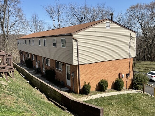
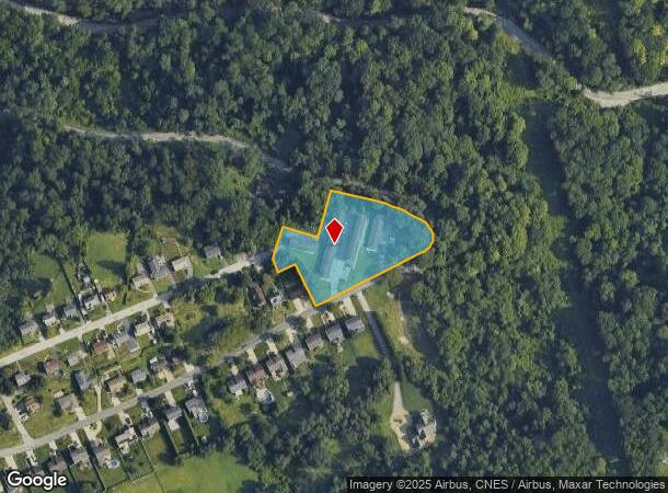
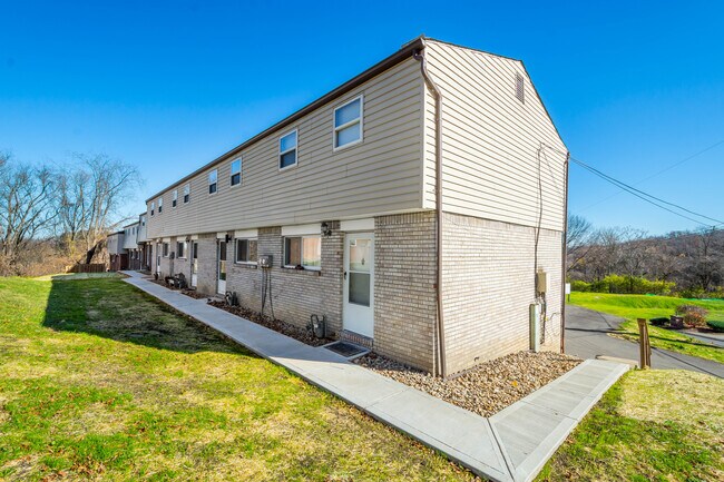
Property Record
1569 Cathell Rd, Pittsburgh, PA 15236

NEARBY LISTINGS FOR SALE OR LEASE
-
-
-
-
-
No Photo
-
View all Pittsburgh listings for sale on LoopNet.com
Property Detail
1569 Cathell Rd
Pittsburgh, PA
Castile Plan
0092-K-00010-0000-01
CASTILE PLAN LOT 2-3-4-5-6-7-8-9-11 = 244.80X37.87X72.05X69.45X260.00X 128.00X53.60X41.36X86.20X98.51X128.00
Apartment
Allegheny
X
Pennsylvania
42003C0364H
10
2024
1.24 AC
2025
Brentwood-Baldwin
480400
Pittsburgh
DEMOGRAPHICS near 1569 Cathell Rd
1 Mile
3 Mile
5 Mile
2024 Total Population
4,051
93,569
337,170
2029 Population
3,963
91,860
332,310
Pop Growth 2024-2029
(2.17%)
(1.83%)
(1.44%)
Average Age
44
42
40
2024 Total Households
1,777
42,233
151,941
HH Growth 2024-2029
(2.19%)
(1.86%)
(1.50%)
Median Household Inc
$76,608
$56,493
$59,936
Avg Household Size
2.20
2.20
2.00
2024 Avg HH Vehicles
2.00
1.00
1.00
Median Home Value
$166,594
$142,358
$168,452
Median Year Built
1959
1950
1951
Nearby Places
Map Layers
Map Styles
 Street
 Aerial
- Restaurants
- Banks
- Shops
- Fitness
- Groceries
PUBLIC TRANSPORTATION
COMMUTER RAIL
Pittsburgh Amtrak Station (Capitol Limited - Amtrak, Pennsylvanian - Amtrak)
DRIVE
WALK
Distance
Pittsburgh Amtrak Station (Capitol Limited - Amtrak, Pennsylvanian - Amtrak)
17 min
6.9 mi
AIRPORT
Pittsburgh International
DRIVE
WALK
Distance
Pittsburgh International
40 min
22.3 mi
Arnold Palmer Regional
DRIVE
WALK
Distance
Arnold Palmer Regional
68 min
36.1 mi
Freight Ports
Port of Baltimore
DRIVE
WALK
Distance
Port of Baltimore
292 min
243.4 mi
SALE & LEASE HISTORY
LISTING DATE
SALE/LEASE

May 01, 2018
For Sale
Mar 26, 2025
For Sale
Feb 23, 2022
For Sale
Nearby Properties
Address
Land Use
TOTAL SIZE
Lot Size
Zoning
Address
Land Use
TOTAL SIZE
Lot Size
Zoning
Address
Land Use
TOTAL SIZE
Lot Size
Zoning
2.30 AC
Address
Land Use
TOTAL SIZE
Lot Size
Zoning
18.66 AC
Address
Land Use
TOTAL SIZE
Lot Size
Zoning
15.90 AC
Address
Land Use
TOTAL SIZE
Lot Size
Zoning
4.49 AC
Address
Land Use
TOTAL SIZE
Lot Size
Zoning
Address
Land Use
TOTAL SIZE
Lot Size
Zoning
16.49 AC
Address
Land Use
TOTAL SIZE
Lot Size
Zoning
Address
Land Use
TOTAL SIZE
Lot Size
Zoning
1.39 AC
Address
Land Use
TOTAL SIZE
Lot Size
Zoning
9.69 AC
Address
Land Use
TOTAL SIZE
Lot Size
Zoning
Address
Land Use
TOTAL SIZE
Lot Size
Zoning
Address
Land Use
TOTAL SIZE
Lot Size
Zoning
23.87 AC
Address
Land Use
TOTAL SIZE
Lot Size
Zoning
11.25 AC
Address
Land Use
TOTAL SIZE
Lot Size
Zoning
5.34 AC
Address
Land Use
TOTAL SIZE
Lot Size
Zoning
162.82 AC
Address
Land Use
TOTAL SIZE
Lot Size
Zoning
1.12 AC
Address
Land Use
TOTAL SIZE
Lot Size
Zoning
Address
Land Use
TOTAL SIZE
Lot Size
Zoning
2.92 AC
Address
Land Use
TOTAL SIZE
Lot Size
Zoning
1.11 AC
Address
Land Use
TOTAL SIZE
Lot Size
Zoning
10.86 AC
Address
Land Use
TOTAL SIZE
Lot Size
Zoning
1.08 AC
Address
Land Use
TOTAL SIZE
Lot Size
Zoning
Address
Land Use
TOTAL SIZE
Lot Size
Zoning
10.75 AC
Address
Land Use
TOTAL SIZE
Lot Size
Zoning
Address
Land Use
TOTAL SIZE
Lot Size
Zoning
1.08 AC
Address
Land Use
TOTAL SIZE
Lot Size
Zoning
0.96 AC
Address
Land Use
TOTAL SIZE
Lot Size
Zoning
1.87 AC
Address
Land Use
TOTAL SIZE
Lot Size
Zoning
Address
Land Use
TOTAL SIZE
Lot Size
Zoning
15.46 AC
The World's #1 Commercial Real Estate Marketplace
Connect with us
© 2026 CoStar Group
The information above has been obtained from sources believed reliable. While we do not doubt its accuracy we have not verified it and make no guarantee, warranty or representation about it. It is your responsibility to independently confirm its accuracy and completeness. Any projections, opinions, assumptions, or estimates used are for example only and do not represent the current or future performance of the property. The value of this transaction to you depends on tax and other factors which should be evaluated by your tax, financial, and legal advisors. You and your advisors should conduct a careful, independent investigation of the property to determine to your satisfaction the suitability of the property for your needs.