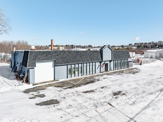
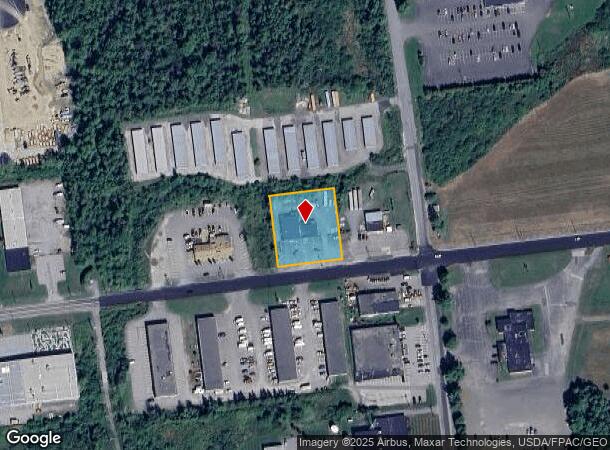
Property Record
1567 Hammond St, Bangor, ME 04401

NEARBY LISTINGS FOR SALE OR LEASE
Property Detail
1567 Hammond St
BANG-000008R-000000-000001-B000000
Penobscot
Industrialgeneral
Maine
A
1-b
23019C2112D
0.85 AC
2024
Maine North & Bangor
2024
Other Market Areas
000700
Bangor, ME
5,568 SF
DEMOGRAPHICS near 1567 Hammond St
1 Mile
3 Mile
5 Mile
2024 Total Population
144
15,392
51,982
2029 Population
153
16,362
55,222
Pop Growth 2024-2029
+ 6.25%
+ 6.30%
+ 6.23%
Average Age
44
43
42
2024 Total Households
64
6,870
23,116
HH Growth 2024-2029
+ 6.25%
+ 6.55%
+ 6.53%
Median Household Inc
$56,666
$58,893
$57,317
Avg Household Size
2.10
2.10
2.10
2024 Avg HH Vehicles
2.00
2.00
2.00
Median Home Value
$194,117
$187,239
$216,922
Median Year Built
1950
1963
1968
Nearby Places
Map Layers
Map Styles
 Street
 Aerial
- Restaurants
- Banks
- Shops
- Fitness
- Groceries
PUBLIC TRANSPORTATION
AIRPORT
Bangor International
DRIVE
WALK
Distance
Bangor International
5 min
1.1 mi
Freight Ports
Searsport, ME
DRIVE
WALK
Distance
Searsport, ME
51 min
32.8 mi
SALE & LEASE HISTORY
LISTING DATE
SALE/LEASE

Apr 18, 2025
For Sale
Nearby Properties
Address
Land Use
TOTAL SIZE
Lot Size
Zoning
Address
Land Use
TOTAL SIZE
Lot Size
Zoning
466.65 AC
ADD
Address
Land Use
TOTAL SIZE
Lot Size
Zoning
76,649 SF
100 AC
G&ISD
Address
Land Use
TOTAL SIZE
Lot Size
Zoning
186,220 SF
93.91 AC
G&SD
Address
Land Use
TOTAL SIZE
Lot Size
Zoning
6.37 AC
UID
Address
Land Use
TOTAL SIZE
Lot Size
Zoning
87,750 SF
ADD
Address
Land Use
TOTAL SIZE
Lot Size
Zoning
12,950 SF
23.39 AC
31 - I
Address
Land Use
TOTAL SIZE
Lot Size
Zoning
38 AC
G&ISD
Address
Land Use
TOTAL SIZE
Lot Size
Zoning
Address
Land Use
TOTAL SIZE
Lot Size
Zoning
115,044 SF
13.30 AC
G&ISD
Address
Land Use
TOTAL SIZE
Lot Size
Zoning
184,000 SF
16.43 AC
31 - I
Address
Land Use
TOTAL SIZE
Lot Size
Zoning
110,031 SF
3.81 AC
GC&S
Address
Land Use
TOTAL SIZE
Lot Size
Zoning
119,930 SF
9.50 AC
S&PS
Address
Land Use
TOTAL SIZE
Lot Size
Zoning
144,000 SF
111.04 AC
32 - I
Address
Land Use
TOTAL SIZE
Lot Size
Zoning
246,766 SF
22.44 AC
S&PS
Address
Land Use
TOTAL SIZE
Lot Size
Zoning
13.58 AC
Address
Land Use
TOTAL SIZE
Lot Size
Zoning
56,910 SF
15 AC
G&ISD
Address
Land Use
TOTAL SIZE
Lot Size
Zoning
33,608 SF
18.10 AC
G&ISD
Address
Land Use
TOTAL SIZE
Lot Size
Zoning
66,333 SF
5.31 AC
GC&S
Address
Land Use
TOTAL SIZE
Lot Size
Zoning
94,280 SF
2.25 AC
G&ISD
Address
Land Use
TOTAL SIZE
Lot Size
Zoning
69.23 AC
Address
Land Use
TOTAL SIZE
Lot Size
Zoning
76,143 SF
1.20 AC
ADD
Address
Land Use
TOTAL SIZE
Lot Size
Zoning
18,286 SF
12.48 AC
I&S
Address
Land Use
TOTAL SIZE
Lot Size
Zoning
21,030 SF
2.50 AC
S&PS
Address
Land Use
TOTAL SIZE
Lot Size
Zoning
186,836 SF
24.53 AC
UID
Address
Land Use
TOTAL SIZE
Lot Size
Zoning
466.65 AC
ADD
Address
Land Use
TOTAL SIZE
Lot Size
Zoning
134,304 SF
11.12 AC
INDUST
Address
Land Use
TOTAL SIZE
Lot Size
Zoning
94,280 SF
2.25 AC
G&ISD
Address
Land Use
TOTAL SIZE
Lot Size
Zoning
4.23 AC
31 - I
Address
Land Use
TOTAL SIZE
Lot Size
Zoning
69,562 SF
8 AC
G&ISD
Address
Land Use
TOTAL SIZE
Lot Size
Zoning
38,280 SF
13 AC
31 - I
The World's #1 Commercial Real Estate Marketplace
Connect with us
© 2025 CoStar Group
The information above has been obtained from sources believed reliable. While we do not doubt its accuracy we have not verified it and make no guarantee, warranty or representation about it. It is your responsibility to independently confirm its accuracy and completeness. Any projections, opinions, assumptions, or estimates used are for example only and do not represent the current or future performance of the property. The value of this transaction to you depends on tax and other factors which should be evaluated by your tax, financial, and legal advisors. You and your advisors should conduct a careful, independent investigation of the property to determine to your satisfaction the suitability of the property for your needs.