Property Record
15670 Wahrman St, Romulus, MI 48174
NEARBY LISTINGS FOR SALE OR LEASE
Property Detail
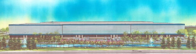
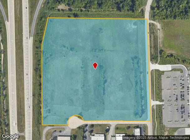
15670 Wahrman St
Detroit-Warren-Dearborn, MI
Huron Eureka Farms
80-125-99-0008-700
32E1A, 1B1A, 1B1B1, 1B1B2 PT OF THE NE 1/4 OF SEC 32 T3S R9E DESC AS BEG AT THE E 1/4 COR OF SEC 32 TH N 01D 50M 28S W 384.38
Industrialacreage
Wayne
AE
Michigan
26163C0359F
0008
2024
21.24 AC
2025
Airport District
986300
Detroit
DEMOGRAPHICS near 15670 Wahrman St
1 Mile
3 Mile
5 Mile
2024 Total Population
179
11,316
48,397
2029 Population
172
10,896
46,398
Pop Growth 2024-2029
(3.91%)
(3.71%)
(4.13%)
Average Age
44
41
39
2024 Total Households
66
4,487
19,047
HH Growth 2024-2029
(4.55%)
(3.66%)
(4.16%)
Median Household Inc
$74,999
$67,795
$66,697
Avg Household Size
2.60
2.50
2.50
2024 Avg HH Vehicles
2.00
2.00
2.00
Median Home Value
$218,000
$185,620
$205,041
Median Year Built
1963
1967
1975
Nearby Places
Map Layers
Map Styles
 Street
 Aerial
- Restaurants
- Banks
- Shops
- Fitness
- Groceries
PUBLIC TRANSPORTATION
AIRPORT
Detroit Metro Wayne County
DRIVE
WALK
Distance
Detroit Metro Wayne County
5 min
3.0 mi
Windsor International
DRIVE
WALK
Distance
Windsor International
51 min
31.4 mi
Freight Ports
Port of Toledo
DRIVE
WALK
Distance
Port of Toledo
57 min
45.9 mi
Nearby Properties
Address
Land Use
TOTAL SIZE
Lot Size
Zoning
Address
Land Use
TOTAL SIZE
Lot Size
Zoning
752,400 SF
72.97 AC
PDA
Address
Land Use
TOTAL SIZE
Lot Size
Zoning
307,524 SF
63.94 AC
AP-AIRPORT
Address
Land Use
TOTAL SIZE
Lot Size
Zoning
516,762 SF
51.63 AC
PDA
Address
Land Use
TOTAL SIZE
Lot Size
Zoning
500,240 SF
M1-LIG
Address
Land Use
TOTAL SIZE
Lot Size
Zoning
108,809 SF
AP-AIRPORT
Address
Land Use
TOTAL SIZE
Lot Size
Zoning
146,562 SF
M2-GEN
Address
Land Use
TOTAL SIZE
Lot Size
Zoning
500,240 SF
55.95 AC
M2-GEN
Address
Land Use
TOTAL SIZE
Lot Size
Zoning
1,141,765 SF
154.21 AC
M2-GEN
Address
Land Use
TOTAL SIZE
Lot Size
Zoning
600,000 SF
M1-LIG
Address
Land Use
TOTAL SIZE
Lot Size
Zoning
268,272 SF
22.70 AC
M-1/COND
Address
Land Use
TOTAL SIZE
Lot Size
Zoning
199,922 SF
30.86 AC
M2-GEN
Address
Land Use
TOTAL SIZE
Lot Size
Zoning
250,263 SF
18.81 AC
RM-MLTI
Address
Land Use
TOTAL SIZE
Lot Size
Zoning
244,760 SF
22.63 AC
M-1/COND
Address
Land Use
TOTAL SIZE
Lot Size
Zoning
462,840 SF
45.66 AC
PDA
Address
Land Use
TOTAL SIZE
Lot Size
Zoning
166,950 SF
22.86 AC
RM-MLTI
Address
Land Use
TOTAL SIZE
Lot Size
Zoning
87,000 SF
18.02 AC
Address
Land Use
TOTAL SIZE
Lot Size
Zoning
129,260 SF
5.25 AC
AP-AIRPORT
Address
Land Use
TOTAL SIZE
Lot Size
Zoning
261,835 SF
45.99 AC
M-T
Address
Land Use
TOTAL SIZE
Lot Size
Zoning
88,790 SF
M2-GEN
Address
Land Use
TOTAL SIZE
Lot Size
Zoning
M1-LIG
Address
Land Use
TOTAL SIZE
Lot Size
Zoning
201,184 SF
10.22 AC
M-2/PDA
Address
Land Use
TOTAL SIZE
Lot Size
Zoning
338,896 SF
14.35 AC
M2-GEN
Address
Land Use
TOTAL SIZE
Lot Size
Zoning
101,200 SF
5.54 AC
AP-AIRPORT
Address
Land Use
TOTAL SIZE
Lot Size
Zoning
105,000 SF
15.26 AC
M2-GEN
Address
Land Use
TOTAL SIZE
Lot Size
Zoning
59,627 SF
9.37 AC
AP-AIRPORT
Address
Land Use
TOTAL SIZE
Lot Size
Zoning
87,000 SF
17.20 AC
B1 LOCA
Address
Land Use
TOTAL SIZE
Lot Size
Zoning
88,790 SF
10.48 AC
M2-GEN
Address
Land Use
TOTAL SIZE
Lot Size
Zoning
79,895 SF
12.56 AC
M2-GEN
Address
Land Use
TOTAL SIZE
Lot Size
Zoning
174,163 SF
17.87 AC
M1 LIG
Address
Land Use
TOTAL SIZE
Lot Size
Zoning
157,099 SF
28.92 AC
M2-GEN
The World's #1 Commercial Real Estate Marketplace
Connect with us
© 2025 CoStar Group
The information above has been obtained from sources believed reliable. While we do not doubt its accuracy we have not verified it and make no guarantee, warranty or representation about it. It is your responsibility to independently confirm its accuracy and completeness. Any projections, opinions, assumptions, or estimates used are for example only and do not represent the current or future performance of the property. The value of this transaction to you depends on tax and other factors which should be evaluated by your tax, financial, and legal advisors. You and your advisors should conduct a careful, independent investigation of the property to determine to your satisfaction the suitability of the property for your needs.