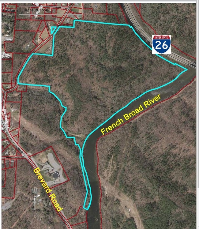
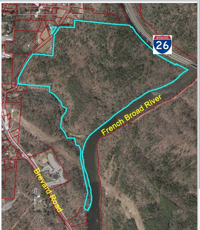
Property Record
1568 Ps Brevard Rd, Asheville, NC 28806

NEARBY LISTINGS FOR SALE OR LEASE
Property Detail
1568 Ps Brevard Rd
Asheville, NC
Bent Crk Property Annexation
9636-10-3860-00000
SUBDIV: BLOCK: LOT: SECTION: PLAT: 0050-0107
Vacantlandnec
Buncombe
AE
North Carolina
3700963600J
tr 1
0
137.22 AC
2025
Buncombe County
001200
Asheville
DEMOGRAPHICS near 1568 Ps Brevard Rd
1 Mile
3 Mile
5 Mile
2024 Total Population
1,275
10,480
66,448
2029 Population
1,290
10,854
69,048
Pop Growth 2024-2029
+ 1.18%
+ 3.57%
+ 3.91%
Average Age
42
41
42
2024 Total Households
585
4,830
29,341
HH Growth 2024-2029
+ 0.68%
+ 2.98%
+ 3.33%
Median Household Inc
$68,855
$76,346
$70,765
Avg Household Size
2.20
2.10
2.20
2024 Avg HH Vehicles
2.00
2.00
2.00
Median Home Value
$281,817
$383,333
$377,024
Median Year Built
1986
2003
1991
Nearby Places
Map Layers
Map Styles
 Street
 Aerial
- Restaurants
- Banks
- Shops
- Fitness
- Groceries
PUBLIC TRANSPORTATION
AIRPORT
Asheville Regional
DRIVE
WALK
Distance
Asheville Regional
15 min
8.4 mi
Freight Ports
North Charleston Terminal
DRIVE
WALK
Distance
North Charleston Terminal
286 min
252.1 mi
SALE & LEASE HISTORY
LISTING DATE
SALE/LEASE

Dec 07, 2016
For Sale
Nearby Properties
Address
Land Use
TOTAL SIZE
Lot Size
Zoning
Address
Land Use
TOTAL SIZE
Lot Size
Zoning
1,204,424 SF
100 AC
EMP
Address
Land Use
TOTAL SIZE
Lot Size
Zoning
13,459 SF
3.07 AC
CR
Address
Land Use
TOTAL SIZE
Lot Size
Zoning
398,787 SF
45.56 AC
RB
Address
Land Use
TOTAL SIZE
Lot Size
Zoning
118,357 SF
24.67 AC
EMP
Address
Land Use
TOTAL SIZE
Lot Size
Zoning
110,173 SF
28.13 AC
R-2
Address
Land Use
TOTAL SIZE
Lot Size
Zoning
83,129 SF
44.74 AC
EMP
Address
Land Use
TOTAL SIZE
Lot Size
Zoning
100,712 SF
24.65 AC
CS
Address
Land Use
TOTAL SIZE
Lot Size
Zoning
98,232 SF
23.24 AC
EMP
Address
Land Use
TOTAL SIZE
Lot Size
Zoning
85,997 SF
29.25 AC
R-3
Address
Land Use
TOTAL SIZE
Lot Size
Zoning
50,672 SF
21.21 AC
R-2
Address
Land Use
TOTAL SIZE
Lot Size
Zoning
57,836 SF
1.09 AC
UV
Address
Land Use
TOTAL SIZE
Lot Size
Zoning
77,056 SF
19.45 AC
EMP
Address
Land Use
TOTAL SIZE
Lot Size
Zoning
3,161 SF
1,161.20 AC
CR
Address
Land Use
TOTAL SIZE
Lot Size
Zoning
218,133 SF
15.39 AC
R-2
Address
Land Use
TOTAL SIZE
Lot Size
Zoning
62,425 SF
10.38 AC
CS
Address
Land Use
TOTAL SIZE
Lot Size
Zoning
332,974 SF
8.38 AC
EMP
Address
Land Use
TOTAL SIZE
Lot Size
Zoning
78,783 SF
9 AC
PS
Address
Land Use
TOTAL SIZE
Lot Size
Zoning
345.09 AC
EMP
Address
Land Use
TOTAL SIZE
Lot Size
Zoning
35,952 SF
9.30 AC
RM16
Address
Land Use
TOTAL SIZE
Lot Size
Zoning
13,347 SF
2.50 AC
RB
Address
Land Use
TOTAL SIZE
Lot Size
Zoning
94,254 SF
43.17 AC
PS
Address
Land Use
TOTAL SIZE
Lot Size
Zoning
21,150 SF
1.14 AC
UV
Address
Land Use
TOTAL SIZE
Lot Size
Zoning
30,184 SF
7.55 AC
EMP
Address
Land Use
TOTAL SIZE
Lot Size
Zoning
13,232 SF
2.05 AC
CBII
Address
Land Use
TOTAL SIZE
Lot Size
Zoning
21,011 SF
2.40 AC
UV
Address
Land Use
TOTAL SIZE
Lot Size
Zoning
70,000 SF
2.31 AC
UV
Address
Land Use
TOTAL SIZE
Lot Size
Zoning
23,727 SF
1.68 AC
RB
Address
Land Use
TOTAL SIZE
Lot Size
Zoning
6,715 SF
1.28 AC
HB
Address
Land Use
TOTAL SIZE
Lot Size
Zoning
28,544 SF
4.97 AC
CI
Address
Land Use
TOTAL SIZE
Lot Size
Zoning
76,453 SF
8.07 AC
RB
The World's #1 Commercial Real Estate Marketplace
Connect with us
© 2026 CoStar Group
The information above has been obtained from sources believed reliable. While we do not doubt its accuracy we have not verified it and make no guarantee, warranty or representation about it. It is your responsibility to independently confirm its accuracy and completeness. Any projections, opinions, assumptions, or estimates used are for example only and do not represent the current or future performance of the property. The value of this transaction to you depends on tax and other factors which should be evaluated by your tax, financial, and legal advisors. You and your advisors should conduct a careful, independent investigation of the property to determine to your satisfaction the suitability of the property for your needs.