Property Record
1569 Dover Rd, Epsom, NH 03234
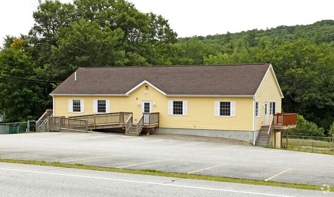

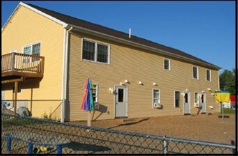
Property Detail
1569 Dover Rd
EPSO-000003U-000000-000039
Merrimack
Commercialbuilding
New Hampshire
RES/CO
39
AE The base floodplain where base flood elevations are provided. AE Zones are now used on new format FIRMs instead of A1-A30 Zones.
3.30 AC
2025
Concord/New Hampshire North Area
2025
Other Market Areas
034000
Concord, NH
2,595 SF
NEARBY LISTINGS FOR SALE OR LEASE
DEMOGRAPHICS near 1569 Dover Rd
1 mile
3 mile
5 mile
2025 Total Population
562
3,809
10,325
2030 Population
570
3,872
10,575
Pop Growth 2025-2030
+ 1.42%
+ 1.65%
+ 2.42%
Average Age
43
43
44
2025 Total Households
211
1,440
4,032
HH Growth 2025-2030
+ 1.42%
+ 1.74%
+ 2.46%
Median Household Inc
$95,046
$95,846
$97,087
Avg Household Size
2.60
2.60
2.50
2025 Avg HH Vehicles
2.00
2.00
2.00
Median Home Value
$362,930
$364,160
$368,466
Median Year Built
1983
1983
1984
Nearby Places
Map Layers
Map Styles
 Street
 Aerial
Layers
 Traffic
 Biking
Places
Listings with unknown addresses are not visible on the map
- Restaurants
- Banks
- Shops
- Fitness
- Groceries
PUBLIC TRANSPORTATION
AIRPORT
Manchester Boston Regional
Drive
Walk
Distance
Manchester Boston Regional
51 min
28.9 mi
Portsmouth International at Pease
Drive
Walk
Distance
Portsmouth International at Pease
52 min
31.7 mi
Freight Ports
Portland, ME
Drive
Walk
Distance
Portland, ME
109 min
73.7 mi
Nearby Properties
Address
Land Use
TOTAL SIZE
Lot Size
Zoning
Address
Land Use
TOTAL SIZE
Lot Size
Zoning
11.40 AC
RES/CO
Address
Land Use
TOTAL SIZE
Lot Size
Zoning
21,411 SF
4.26 AC
RES/CO
Address
Land Use
TOTAL SIZE
Lot Size
Zoning
28.02 AC
RES/AG
Address
Land Use
TOTAL SIZE
Lot Size
Zoning
43,998 SF
15.59 AC
RES/CO
Address
Land Use
TOTAL SIZE
Lot Size
Zoning
36,395 SF
5.04 AC
RES/CO
Address
Land Use
TOTAL SIZE
Lot Size
Zoning
30,540 SF
11.94 AC
RES/CO
Address
Land Use
TOTAL SIZE
Lot Size
Zoning
17,783 SF
11.10 AC
COMM/I
Address
Land Use
TOTAL SIZE
Lot Size
Zoning
30,221 SF
4.55 AC
RES/CO
Address
Land Use
TOTAL SIZE
Lot Size
Zoning
23.91 AC
RES/AG
Address
Land Use
TOTAL SIZE
Lot Size
Zoning
5,751 SF
2.94 AC
RES/CO
Address
Land Use
TOTAL SIZE
Lot Size
Zoning
16,306 SF
28.99 AC
COMM/I
Address
Land Use
TOTAL SIZE
Lot Size
Zoning
2.72 AC
RES/CO
Address
Land Use
TOTAL SIZE
Lot Size
Zoning
4.16 AC
RES/LT
Address
Land Use
TOTAL SIZE
Lot Size
Zoning
20.95 AC
RES/CO
Address
Land Use
TOTAL SIZE
Lot Size
Zoning
5.01 AC
RES/CO
Address
Land Use
TOTAL SIZE
Lot Size
Zoning
6.87 AC
RES/LT
Address
Land Use
TOTAL SIZE
Lot Size
Zoning
6.57 AC
RES/CO
Address
Land Use
TOTAL SIZE
Lot Size
Zoning
11,235 SF
1.24 AC
RES/CO
Address
Land Use
TOTAL SIZE
Lot Size
Zoning
15,257 SF
3.51 AC
RES/CO
Address
Land Use
TOTAL SIZE
Lot Size
Zoning
8,064 SF
12.68 AC
RES/CO
Address
Land Use
TOTAL SIZE
Lot Size
Zoning
1.06 AC
R/C NO
Address
Land Use
TOTAL SIZE
Lot Size
Zoning
13,410 SF
3.69 AC
RES/CO
Address
Land Use
TOTAL SIZE
Lot Size
Zoning
4,991 SF
2.87 AC
RES/CO
Address
Land Use
TOTAL SIZE
Lot Size
Zoning
2,930 SF
48 AC
RES/AG
Address
Land Use
TOTAL SIZE
Lot Size
Zoning
5,673 SF
8.90 AC
RES/CO
Address
Land Use
TOTAL SIZE
Lot Size
Zoning
2.93 AC
RES/CO
Address
Land Use
TOTAL SIZE
Lot Size
Zoning
7,870 SF
16.69 AC
RES/CO
Address
Land Use
TOTAL SIZE
Lot Size
Zoning
1.50 AC
NWL RN
Address
Land Use
TOTAL SIZE
Lot Size
Zoning
9,993 SF
3.46 AC
RES/CO
Address
Land Use
TOTAL SIZE
Lot Size
Zoning
2.90 AC
RES/LT
The World's #1 Commercial Real Estate Marketplace
Connect with us
© 2026 CoStar Group
The information above has been obtained from sources believed reliable. While we do not doubt its accuracy we have not verified it and make no guarantee, warranty or representation about it. It is your responsibility to independently confirm its accuracy and completeness. Any projections, opinions, assumptions, or estimates used are for example only and do not represent the current or future performance of the property. The value of this transaction to you depends on tax and other factors which should be evaluated by your tax, financial, and legal advisors. You and your advisors should conduct a careful, independent investigation of the property to determine to your satisfaction the suitability of the property for your needs.