Property Record
1569 Fulenwider Rd, Gainesville, GA 30507
Current Lease Availabilities
NEARBY LISTINGS FOR SALE OR LEASE
Property Detail
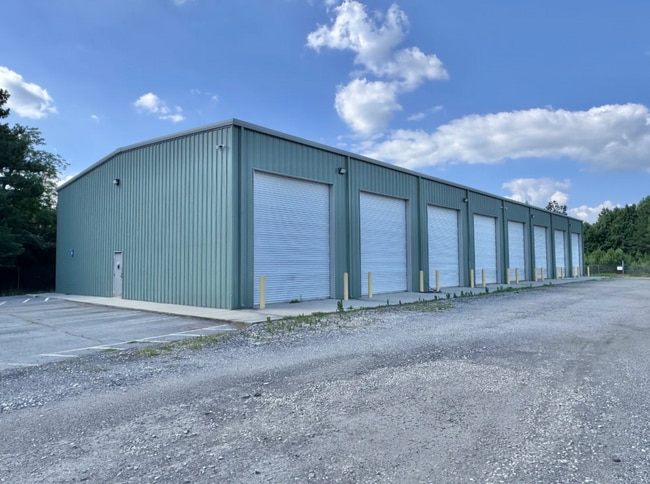
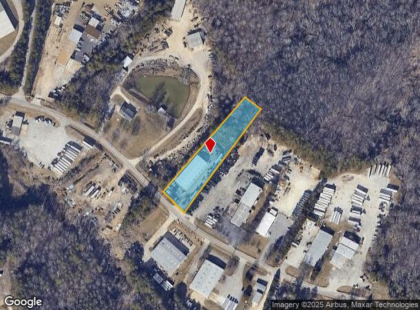
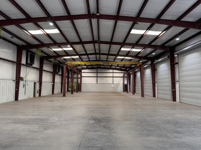
1569 Fulenwider Rd
15-00031-00-136
1569 FULENWIDER ROAD
Autorepair
Hall
X
Georgia
13139C0195H
1.61 AC
2025
I-985/Gainesville
2025
Atlanta
001202
Gainesville, GA
9,600 SF
DEMOGRAPHICS near 1569 Fulenwider Rd
1 Mile
3 Mile
5 Mile
2024 Total Population
315
22,503
73,869
2029 Population
349
24,771
81,596
Pop Growth 2024-2029
+ 10.79%
+ 10.08%
+ 10.46%
Average Age
34
32
35
2024 Total Households
55
6,045
23,495
HH Growth 2024-2029
+ 10.91%
+ 9.96%
+ 10.42%
Median Household Inc
$69,749
$52,847
$54,665
Avg Household Size
3.70
3.40
3.00
2024 Avg HH Vehicles
3.00
2.00
2.00
Median Home Value
$210,000
$165,856
$221,125
Median Year Built
1994
1992
1992
Nearby Places
- Restaurants
- Banks
- Shops
- Fitness
- Groceries
PUBLIC TRANSPORTATION
COMMUTER RAIL
Gainesville Amtrak Station (Crescent - Amtrak)
DRIVE
WALK
Distance
Gainesville Amtrak Station (Crescent - Amtrak)
6 min
3.1 mi
Freight Ports
Georgia Ports - Savannah
DRIVE
WALK
Distance
Georgia Ports - Savannah
319 min
252.4 mi
Nearby Properties
Address
Land Use
TOTAL SIZE
Lot Size
Zoning
Address
Land Use
TOTAL SIZE
Lot Size
Zoning
578,645 SF
110.18 AC
PUD
Address
Land Use
TOTAL SIZE
Lot Size
Zoning
334,800 SF
56.96 AC
PUD
Address
Land Use
TOTAL SIZE
Lot Size
Zoning
258,201 SF
38.83 AC
I-1
Address
Land Use
TOTAL SIZE
Lot Size
Zoning
3,284 SF
28.53 AC
PUD
Address
Land Use
TOTAL SIZE
Lot Size
Zoning
100,864 SF
4.10 AC
PUD
Address
Land Use
TOTAL SIZE
Lot Size
Zoning
77,333 SF
11.74 AC
PUD
Address
Land Use
TOTAL SIZE
Lot Size
Zoning
346,875 SF
82.09 AC
H-I
Address
Land Use
TOTAL SIZE
Lot Size
Zoning
54,751 SF
33.38 AC
AR-1
Address
Land Use
TOTAL SIZE
Lot Size
Zoning
469,180 SF
25.56 AC
H-I
Address
Land Use
TOTAL SIZE
Lot Size
Zoning
258,372 SF
24.38 AC
L-I
Address
Land Use
TOTAL SIZE
Lot Size
Zoning
88,042 SF
280.24 AC
PID
Address
Land Use
TOTAL SIZE
Lot Size
Zoning
308,672 SF
41.22 AC
L-I
Address
Land Use
TOTAL SIZE
Lot Size
Zoning
1,191 SF
262.63 AC
H-I
Address
Land Use
TOTAL SIZE
Lot Size
Zoning
258,800 SF
52.20 AC
H-I
Address
Land Use
TOTAL SIZE
Lot Size
Zoning
304,088 SF
17.45 AC
H-I
Address
Land Use
TOTAL SIZE
Lot Size
Zoning
102,996 SF
10.94 AC
L-I
Address
Land Use
TOTAL SIZE
Lot Size
Zoning
199,610 SF
14.66 AC
L-I
Address
Land Use
TOTAL SIZE
Lot Size
Zoning
194,850 SF
9.28 AC
L-I
Address
Land Use
TOTAL SIZE
Lot Size
Zoning
91,728 SF
15 AC
L-I
Address
Land Use
TOTAL SIZE
Lot Size
Zoning
286,880 SF
18.38 AC
H-I
Address
Land Use
TOTAL SIZE
Lot Size
Zoning
206,125 SF
32.78 AC
L-I
Address
Land Use
TOTAL SIZE
Lot Size
Zoning
145,064 SF
7.47 AC
I-1
Address
Land Use
TOTAL SIZE
Lot Size
Zoning
6,720 SF
1,027.20 AC
EX
Address
Land Use
TOTAL SIZE
Lot Size
Zoning
33,351 SF
16.80 AC
R-1
Address
Land Use
TOTAL SIZE
Lot Size
Zoning
162,813 SF
11.24 AC
H-I
Address
Land Use
TOTAL SIZE
Lot Size
Zoning
25,805 SF
8.30 AC
O-I
Address
Land Use
TOTAL SIZE
Lot Size
Zoning
50,000 SF
12.53 AC
L-I
Address
Land Use
TOTAL SIZE
Lot Size
Zoning
20,250 SF
23.43 AC
H-I
Address
Land Use
TOTAL SIZE
Lot Size
Zoning
43,170 SF
23.06 AC
PUD
Address
Land Use
TOTAL SIZE
Lot Size
Zoning
67,624 SF
163.46 AC
EX
The World's #1 Commercial Real Estate Marketplace
Connect with us
© 2025 CoStar Group
The information above has been obtained from sources believed reliable. While we do not doubt its accuracy we have not verified it and make no guarantee, warranty or representation about it. It is your responsibility to independently confirm its accuracy and completeness. Any projections, opinions, assumptions, or estimates used are for example only and do not represent the current or future performance of the property. The value of this transaction to you depends on tax and other factors which should be evaluated by your tax, financial, and legal advisors. You and your advisors should conduct a careful, independent investigation of the property to determine to your satisfaction the suitability of the property for your needs.