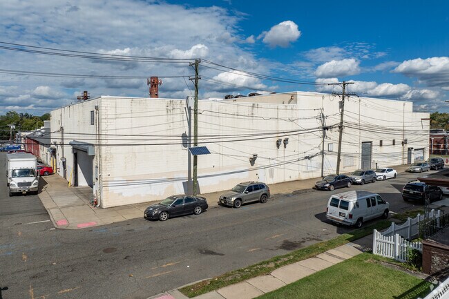
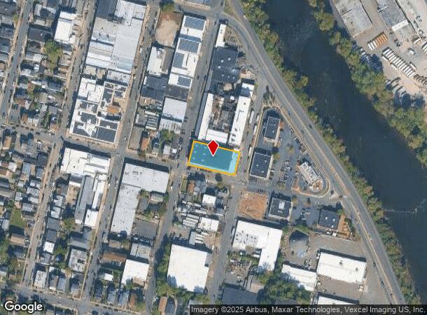
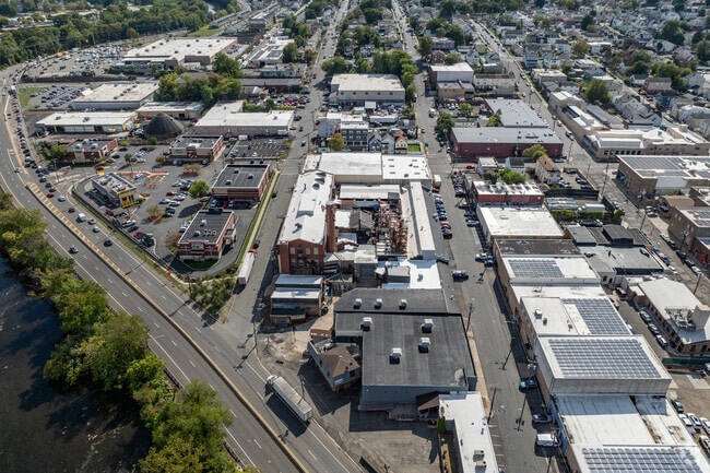
Property Record
157 3Rd Ave, Paterson, NJ 07514
NEARBY LISTINGS FOR SALE OR LEASE
Property Detail
157 3Rd Ave
08-02308-0000-00002
Passaic
Industrialgeneral
New Jersey
X
2
34031C0217G
0.46 AC
2024
Paterson
2025
Northern New Jersey
181200
New York-Jersey City-White Plains, NY-NJ
32,600 SF
DEMOGRAPHICS near 157 3Rd Ave
1 Mile
3 Mile
5 Mile
2024 Total Population
29,918
242,414
495,183
2029 Population
28,543
234,376
481,550
Pop Growth 2024-2029
(4.60%)
(3.32%)
(2.75%)
Average Age
38
38
39
2024 Total Households
9,889
79,796
165,596
HH Growth 2024-2029
(4.76%)
(3.40%)
(2.86%)
Median Household Inc
$70,597
$70,316
$82,386
Avg Household Size
2.90
2.90
2.90
2024 Avg HH Vehicles
2.00
1.00
2.00
Median Home Value
$419,967
$445,472
$478,115
Median Year Built
1948
1953
1954
Nearby Places
Map Layers
Map Styles
 Street
 Aerial
- Restaurants
- Banks
- Shops
- Fitness
- Groceries
PUBLIC TRANSPORTATION
COMMUTER RAIL
Hawthorne (Main/Port Jervis Line - NJ Transit Commuter Rail (NJ Transit))
DRIVE
WALK
Distance
Hawthorne (Main/Port Jervis Line - NJ Transit Commuter Rail (NJ Transit))
2 min
1.1 mi
Radburn (Bergen County/Port Jervis Line - NJ Transit Commuter Rail (NJ Transit))
DRIVE
WALK
Distance
Radburn (Bergen County/Port Jervis Line - NJ Transit Commuter Rail (NJ Transit))
4 min
1.9 mi
AIRPORT
Newark Liberty International
DRIVE
WALK
Distance
Newark Liberty International
27 min
21.9 mi
LaGuardia
DRIVE
WALK
Distance
LaGuardia
36 min
23.5 mi
Westchester County
DRIVE
WALK
Distance
Westchester County
57 min
39.3 mi
Freight Ports
Port Newark Container Terminal
DRIVE
WALK
Distance
Port Newark Container Terminal
31 min
21.2 mi
Nearby Properties
Address
Land Use
TOTAL SIZE
Lot Size
Zoning
Address
Land Use
TOTAL SIZE
Lot Size
Zoning
466,866 SF
154.93 AC
R150
Address
Land Use
TOTAL SIZE
Lot Size
Zoning
8.75 AC
Address
Land Use
TOTAL SIZE
Lot Size
Zoning
12,506 SF
130 AC
B-2
Address
Land Use
TOTAL SIZE
Lot Size
Zoning
7,060 SF
115.84 AC
HP
Address
Land Use
TOTAL SIZE
Lot Size
Zoning
45,000 SF
124.04 AC
R-A
Address
Land Use
TOTAL SIZE
Lot Size
Zoning
12,268 SF
98 AC
CR
Address
Land Use
TOTAL SIZE
Lot Size
Zoning
79,310 SF
2 AC
B-2
Address
Land Use
TOTAL SIZE
Lot Size
Zoning
26,816 SF
25.50 AC
POP
Address
Land Use
TOTAL SIZE
Lot Size
Zoning
9.96 AC
MU
Address
Land Use
TOTAL SIZE
Lot Size
Zoning
Address
Land Use
TOTAL SIZE
Lot Size
Zoning
152,050 SF
1.96 AC
B-1
Address
Land Use
TOTAL SIZE
Lot Size
Zoning
57,680 SF
20.01 AC
CR
Address
Land Use
TOTAL SIZE
Lot Size
Zoning
84.08 AC
Address
Land Use
TOTAL SIZE
Lot Size
Zoning
7.83 AC
Address
Land Use
TOTAL SIZE
Lot Size
Zoning
1.80 AC
Address
Land Use
TOTAL SIZE
Lot Size
Zoning
0.69 AC
I-1
Address
Land Use
TOTAL SIZE
Lot Size
Zoning
19.20 AC
Address
Land Use
TOTAL SIZE
Lot Size
Zoning
824,024 SF
39.71 AC
I1
Address
Land Use
TOTAL SIZE
Lot Size
Zoning
90.48 AC
Address
Land Use
TOTAL SIZE
Lot Size
Zoning
210,907 SF
10 AC
R100
Address
Land Use
TOTAL SIZE
Lot Size
Zoning
Address
Land Use
TOTAL SIZE
Lot Size
Zoning
5.88 AC
Address
Land Use
TOTAL SIZE
Lot Size
Zoning
59.45 AC
R100
Address
Land Use
TOTAL SIZE
Lot Size
Zoning
27.25 AC
Address
Land Use
TOTAL SIZE
Lot Size
Zoning
764,364 SF
16.60 AC
I-2
Address
Land Use
TOTAL SIZE
Lot Size
Zoning
11.87 AC
Address
Land Use
TOTAL SIZE
Lot Size
Zoning
0.12 AC
Address
Land Use
TOTAL SIZE
Lot Size
Zoning
22,892 SF
132.80 AC
RGC
Address
Land Use
TOTAL SIZE
Lot Size
Zoning
Address
Land Use
TOTAL SIZE
Lot Size
Zoning
192,252 SF
5 AC
The World's #1 Commercial Real Estate Marketplace
Connect with us
© 2025 CoStar Group
The information above has been obtained from sources believed reliable. While we do not doubt its accuracy we have not verified it and make no guarantee, warranty or representation about it. It is your responsibility to independently confirm its accuracy and completeness. Any projections, opinions, assumptions, or estimates used are for example only and do not represent the current or future performance of the property. The value of this transaction to you depends on tax and other factors which should be evaluated by your tax, financial, and legal advisors. You and your advisors should conduct a careful, independent investigation of the property to determine to your satisfaction the suitability of the property for your needs.