Property Record
157 E Panama Rd, Bakersfield, CA 93307
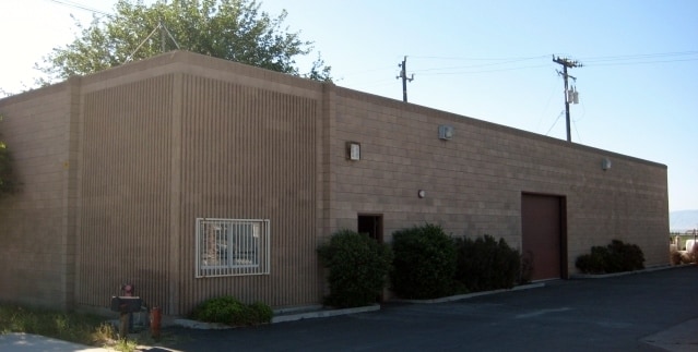

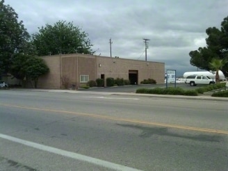

Property Detail
157 E Panama Rd
185-060-33-00-2
SECTION 5 , TOWNSHIP 31 , RANGE 28 , QUARTER
Warehouse
KERN
C-2
California
B and X Area of moderate flood hazard, usually the area between the limits of the 100-year and 500-year floods.
0.23 AC
2024
SE Outlying Kern County
2025
Bakersfield
002403
Bakersfield-Delano, CA
4,000 SF
NEARBY LISTINGS FOR SALE OR LEASE
-
-
View all Bakersfield listings for sale on LoopNet.com
DEMOGRAPHICS near 157 E Panama Rd
1 mile
3 mile
5 mile
2025 Total Population
4,507
51,215
136,060
2030 Population
4,571
51,741
137,510
Pop Growth 2025-2030
+ 1.42%
+ 1.03%
+ 1.07%
Average Age
37
34
34
2025 Total Households
1,384
13,234
37,338
HH Growth 2025-2030
+ 1.30%
+ 0.99%
+ 1.01%
Median Household Inc
$54,875
$73,985
$70,741
Avg Household Size
3.30
3.80
3.50
2025 Avg HH Vehicles
2.00
2.00
2.00
Median Home Value
$337,810
$336,740
$327,967
Median Year Built
1987
1994
1987
Nearby Places
Map Layers
Map Styles
 Street
 Aerial
Layers
 Traffic
 Biking
Places
Listings with unknown addresses are not visible on the map
- Restaurants
- Banks
- Shops
- Fitness
- Groceries
PUBLIC TRANSPORTATION
COMMUTER RAIL
Drive
Walk
Distance
14 min
8.1 mi
AIRPORT
Meadows Field
Drive
Walk
Distance
Meadows Field
24 min
14.1 mi
SALE & LEASE HISTORY
LISTING DATE
SALE/LEASE

Jul 25, 2024
For Lease
Jan 30, 2025
For Sale
Nearby Properties
Address
Land Use
TOTAL SIZE
Lot Size
Zoning
Address
Land Use
TOTAL SIZE
Lot Size
Zoning
17.96 AC
C2
Address
Land Use
TOTAL SIZE
Lot Size
Zoning
218,345 SF
19.54 AC
PCD
Address
Land Use
TOTAL SIZE
Lot Size
Zoning
11,780 SF
11.25 AC
C1
Address
Land Use
TOTAL SIZE
Lot Size
Zoning
149,499 SF
13.20 AC
GC
Address
Land Use
TOTAL SIZE
Lot Size
Zoning
41,507 SF
10.37 AC
C2
Address
Land Use
TOTAL SIZE
Lot Size
Zoning
34,306 SF
12.39 AC
R-2
Address
Land Use
TOTAL SIZE
Lot Size
Zoning
94,240 SF
4.95 AC
C-2
Address
Land Use
TOTAL SIZE
Lot Size
Zoning
7.62 AC
C2
Address
Land Use
TOTAL SIZE
Lot Size
Zoning
10.37 AC
C2
Address
Land Use
TOTAL SIZE
Lot Size
Zoning
41.06 AC
Address
Land Use
TOTAL SIZE
Lot Size
Zoning
629.08 AC
A
Address
Land Use
TOTAL SIZE
Lot Size
Zoning
14,736 SF
1.71 AC
C2
Address
Land Use
TOTAL SIZE
Lot Size
Zoning
21,704 SF
3.44 AC
C-2
Address
Land Use
TOTAL SIZE
Lot Size
Zoning
2,179 SF
14.05 AC
PCD
Address
Land Use
TOTAL SIZE
Lot Size
Zoning
10,009 SF
20.04 AC
R-1
Address
Land Use
TOTAL SIZE
Lot Size
Zoning
8,400 SF
4.78 AC
C1
Address
Land Use
TOTAL SIZE
Lot Size
Zoning
990 SF
151.39 AC
A1
Address
Land Use
TOTAL SIZE
Lot Size
Zoning
20,169 SF
4.12 AC
C-2
Address
Land Use
TOTAL SIZE
Lot Size
Zoning
36,320 SF
3.90 AC
C-2
Address
Land Use
TOTAL SIZE
Lot Size
Zoning
14,490 SF
15.83 AC
R1
Address
Land Use
TOTAL SIZE
Lot Size
Zoning
16,632 SF
2.19 AC
C-1
Address
Land Use
TOTAL SIZE
Lot Size
Zoning
0.18 AC
R1
Address
Land Use
TOTAL SIZE
Lot Size
Zoning
2,792 SF
1.03 AC
M1
Address
Land Use
TOTAL SIZE
Lot Size
Zoning
12.65 AC
R1
Address
Land Use
TOTAL SIZE
Lot Size
Zoning
15,037 SF
1.57 AC
C-2
Address
Land Use
TOTAL SIZE
Lot Size
Zoning
16.92 AC
A
Address
Land Use
TOTAL SIZE
Lot Size
Zoning
0.96 AC
Address
Land Use
TOTAL SIZE
Lot Size
Zoning
14.45 AC
R1
The World's #1 Commercial Real Estate Marketplace
Connect with us
© 2026 CoStar Group
The information above has been obtained from sources believed reliable. While we do not doubt its accuracy we have not verified it and make no guarantee, warranty or representation about it. It is your responsibility to independently confirm its accuracy and completeness. Any projections, opinions, assumptions, or estimates used are for example only and do not represent the current or future performance of the property. The value of this transaction to you depends on tax and other factors which should be evaluated by your tax, financial, and legal advisors. You and your advisors should conduct a careful, independent investigation of the property to determine to your satisfaction the suitability of the property for your needs.