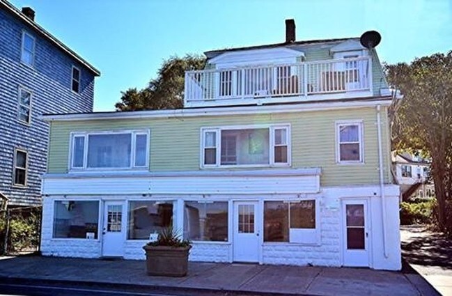
Property Record
157 Nahant Rd, Nahant, MA 01908


Save to a Folder
{{folder.Name}}
{{folder.ListingIds.length}} Properties
{{folder.ListingIds.length}} Property
Create a New Folder
Property Detail
157 Nahant Rd
NAHA-000016-000000-000050
Essex
Commercialofficeresidentialmixeduse
Massachusetts
B1
50
AE The base floodplain where base flood elevations are provided. AE Zones are now used on new format FIRMs instead of A1-A30 Zones.
0.28 AC
2025
Saugus/Lynn
2025
Boston
201100
Boston-Cambridge-Newton, MA-NH
2,873 SF
NEARBY LISTINGS FOR SALE OR LEASE
DEMOGRAPHICS near 157 Nahant Rd
1 mile
3 mile
5 mile
2025 Total Population
3,521
43,936
218,563
2030 Population
3,640
44,752
221,147
Pop Growth 2025-2030
+ 3.38%
+ 1.86%
+ 1.18%
Average Age
50
41
40
2025 Total Households
1,625
17,863
80,822
HH Growth 2025-2030
+ 3.20%
+ 2.08%
+ 1.35%
Median Household Inc
$113,671
$56,499
$83,809
Avg Household Size
2.10
2.30
2.60
2025 Avg HH Vehicles
2.00
1.00
2.00
Median Home Value
$800,687
$599,437
$626,082
Median Year Built
1948
1949
1951
Nearby Places
Map Layers
Map Styles
 Street
 Aerial
Layers
 Traffic
 Biking
Places
Listings with unknown addresses are not visible on the map
- Restaurants
- Banks
- Shops
- Fitness
- Groceries
PUBLIC TRANSPORTATION
COMMUTER RAIL
Drive
Walk
Distance
9 min
3.3 mi
Swampscott (Newburyport/Rockport Line - Massachusetts Bay Transportation Authority Commuter Rail (Purple Line))
Drive
Walk
Distance
Swampscott (Newburyport/Rockport Line - Massachusetts Bay Transportation Authority Commuter Rail (Purple Line))
8 min
3.9 mi
AIRPORT
General Edward Lawrence Logan International
Drive
Walk
Distance
General Edward Lawrence Logan International
22 min
11.6 mi
Freight Ports
Port of Boston
Drive
Walk
Distance
Port of Boston
28 min
14.3 mi
Nearby Properties
Address
Land Use
TOTAL SIZE
Lot Size
Zoning
Address
Land Use
TOTAL SIZE
Lot Size
Zoning
9.73 AC
R5
Address
Land Use
TOTAL SIZE
Lot Size
Zoning
224,840 SF
2.18 AC
RC1
Address
Land Use
TOTAL SIZE
Lot Size
Zoning
277,750 SF
13.47 AC
LI
Address
Land Use
TOTAL SIZE
Lot Size
Zoning
11,840 SF
0.67 AC
CBD
Address
Land Use
TOTAL SIZE
Lot Size
Zoning
4.51 AC
R5
Address
Land Use
TOTAL SIZE
Lot Size
Zoning
345,298 SF
5.74 AC
WF1
Address
Land Use
TOTAL SIZE
Lot Size
Zoning
303,568 SF
1.11 AC
LI
Address
Land Use
TOTAL SIZE
Lot Size
Zoning
8.74 AC
WF1A
Address
Land Use
TOTAL SIZE
Lot Size
Zoning
123,903 SF
0.88 AC
CBD
Address
Land Use
TOTAL SIZE
Lot Size
Zoning
3.22 AC
R5
Address
Land Use
TOTAL SIZE
Lot Size
Zoning
15,240 SF
11.49 AC
WF3
Address
Land Use
TOTAL SIZE
Lot Size
Zoning
208,440 SF
1.49 AC
GB
Address
Land Use
TOTAL SIZE
Lot Size
Zoning
5.40 AC
R5
Address
Land Use
TOTAL SIZE
Lot Size
Zoning
25.02 AC
WF1A
Address
Land Use
TOTAL SIZE
Lot Size
Zoning
68,296 SF
6.01 AC
R2
Address
Land Use
TOTAL SIZE
Lot Size
Zoning
84,681 SF
3.53 AC
R5
Address
Land Use
TOTAL SIZE
Lot Size
Zoning
65.50 AC
WF1
Address
Land Use
TOTAL SIZE
Lot Size
Zoning
2.88 AC
R5
Address
Land Use
TOTAL SIZE
Lot Size
Zoning
3.02 AC
RC1
Address
Land Use
TOTAL SIZE
Lot Size
Zoning
174,401 SF
10.85 AC
HI
Address
Land Use
TOTAL SIZE
Lot Size
Zoning
95,160 SF
0.89 AC
NB
Address
Land Use
TOTAL SIZE
Lot Size
Zoning
71,612 SF
1.17 AC
WF1
Address
Land Use
TOTAL SIZE
Lot Size
Zoning
104,108 SF
1.19 AC
LI
Address
Land Use
TOTAL SIZE
Lot Size
Zoning
98,190 SF
0.59 AC
R5
Address
Land Use
TOTAL SIZE
Lot Size
Zoning
129,010 SF
1.08 AC
R5
Address
Land Use
TOTAL SIZE
Lot Size
Zoning
161,036 SF
5.16 AC
LI
Address
Land Use
TOTAL SIZE
Lot Size
Zoning
111,440 SF
1.19 AC
CBD
Address
Land Use
TOTAL SIZE
Lot Size
Zoning
59,618 SF
2 AC
B
Address
Land Use
TOTAL SIZE
Lot Size
Zoning
93,079 SF
0.63 AC
CBD
The World's #1 Commercial Real Estate Marketplace
Connect with us
© 2026 CoStar Group
The information above has been obtained from sources believed reliable. While we do not doubt its accuracy we have not verified it and make no guarantee, warranty or representation about it. It is your responsibility to independently confirm its accuracy and completeness. Any projections, opinions, assumptions, or estimates used are for example only and do not represent the current or future performance of the property. The value of this transaction to you depends on tax and other factors which should be evaluated by your tax, financial, and legal advisors. You and your advisors should conduct a careful, independent investigation of the property to determine to your satisfaction the suitability of the property for your needs.