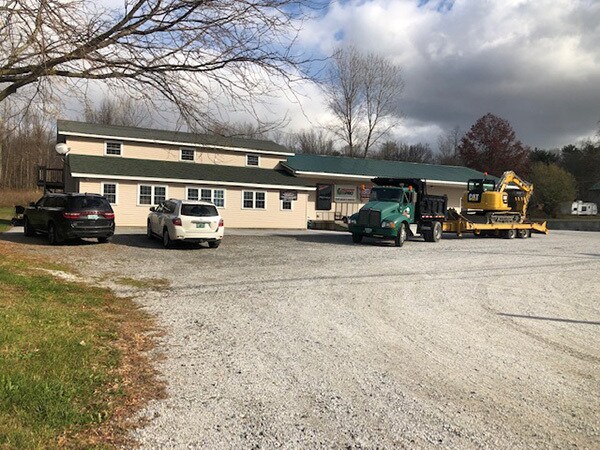
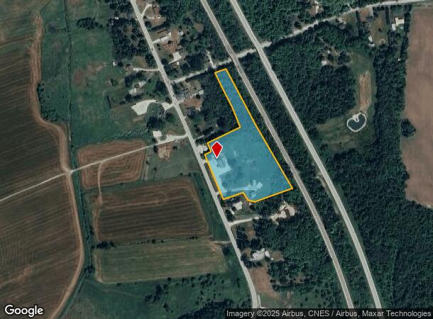
Property Record
157 St Albans Rd, Swanton, VT 05488
NEARBY LISTINGS FOR SALE OR LEASE
-
-
View all Swanton listings for lease on LoopNet.com
Property Detail
157 St Albans Rd
639-201-12593
Franklin
Commercialnec
Vermont
2024
7.09 AC
2024
Vermont North Area
010500
Other Market Areas
2,719 SF
Burlington-South Burlington, VT
DEMOGRAPHICS near 157 St Albans Rd
1 Mile
3 Mile
5 Mile
2024 Total Population
369
6,005
11,729
2029 Population
388
6,288
12,271
Pop Growth 2024-2029
+ 5.15%
+ 4.71%
+ 4.62%
Average Age
42
41
42
2024 Total Households
145
2,412
4,645
HH Growth 2024-2029
+ 4.83%
+ 4.56%
+ 4.52%
Median Household Inc
$86,742
$71,452
$71,056
Avg Household Size
2.50
2.40
2.40
2024 Avg HH Vehicles
2.00
2.00
2.00
Median Home Value
$320,000
$248,750
$254,124
Median Year Built
1993
1976
1976
Nearby Places
Map Layers
Map Styles
 Street
 Aerial
- Restaurants
- Banks
- Shops
- Fitness
- Groceries
PUBLIC TRANSPORTATION
COMMUTER RAIL
St. Albans Amtrak Station (Vermonter - Amtrak)
DRIVE
WALK
Distance
St. Albans Amtrak Station (Vermonter - Amtrak)
9 min
6.0 mi
AIRPORT
Patrick Leahy Burlington International
DRIVE
WALK
Distance
Patrick Leahy Burlington International
50 min
34.2 mi
Plattsburgh International
DRIVE
WALK
Distance
Plattsburgh International
62 min
49.8 mi
Freight Ports
Montreal
DRIVE
WALK
Distance
Montreal
87 min
65.6 mi
SALE & LEASE HISTORY
LISTING DATE
SALE/LEASE

Apr 17, 2020
For Lease
Nearby Properties
Address
Land Use
TOTAL SIZE
Lot Size
Zoning
Address
Land Use
TOTAL SIZE
Lot Size
Zoning
39 AC
Address
Land Use
TOTAL SIZE
Lot Size
Zoning
67.10 AC
Address
Land Use
TOTAL SIZE
Lot Size
Zoning
17.03 AC
Address
Land Use
TOTAL SIZE
Lot Size
Zoning
15.43 AC
Address
Land Use
TOTAL SIZE
Lot Size
Zoning
105,828 SF
13.61 AC
Address
Land Use
TOTAL SIZE
Lot Size
Zoning
0.21 AC
Address
Land Use
TOTAL SIZE
Lot Size
Zoning
Address
Land Use
TOTAL SIZE
Lot Size
Zoning
1,168.98 AC
Address
Land Use
TOTAL SIZE
Lot Size
Zoning
2.90 AC
Address
Land Use
TOTAL SIZE
Lot Size
Zoning
Address
Land Use
TOTAL SIZE
Lot Size
Zoning
455.54 AC
Address
Land Use
TOTAL SIZE
Lot Size
Zoning
9.04 AC
Address
Land Use
TOTAL SIZE
Lot Size
Zoning
5,368 SF
6.32 AC
Address
Land Use
TOTAL SIZE
Lot Size
Zoning
0.25 AC
Address
Land Use
TOTAL SIZE
Lot Size
Zoning
448.91 AC
Address
Land Use
TOTAL SIZE
Lot Size
Zoning
5.73 AC
Address
Land Use
TOTAL SIZE
Lot Size
Zoning
4,272 SF
142.40 AC
Address
Land Use
TOTAL SIZE
Lot Size
Zoning
0.12 AC
Address
Land Use
TOTAL SIZE
Lot Size
Zoning
9,600 SF
1.60 AC
Address
Land Use
TOTAL SIZE
Lot Size
Zoning
610.10 AC
Address
Land Use
TOTAL SIZE
Lot Size
Zoning
1.78 AC
Address
Land Use
TOTAL SIZE
Lot Size
Zoning
3,312 SF
20.19 AC
Address
Land Use
TOTAL SIZE
Lot Size
Zoning
0.10 AC
Address
Land Use
TOTAL SIZE
Lot Size
Zoning
41,168 SF
4.20 AC
Address
Land Use
TOTAL SIZE
Lot Size
Zoning
3,200 SF
7.05 AC
Address
Land Use
TOTAL SIZE
Lot Size
Zoning
5,816 SF
1.61 AC
Address
Land Use
TOTAL SIZE
Lot Size
Zoning
17,612 SF
1.76 AC
Address
Land Use
TOTAL SIZE
Lot Size
Zoning
0.19 AC
Address
Land Use
TOTAL SIZE
Lot Size
Zoning
16,164 SF
1.71 AC
Address
Land Use
TOTAL SIZE
Lot Size
Zoning
2.94 AC
The World's #1 Commercial Real Estate Marketplace
Connect with us
© 2026 CoStar Group
The information above has been obtained from sources believed reliable. While we do not doubt its accuracy we have not verified it and make no guarantee, warranty or representation about it. It is your responsibility to independently confirm its accuracy and completeness. Any projections, opinions, assumptions, or estimates used are for example only and do not represent the current or future performance of the property. The value of this transaction to you depends on tax and other factors which should be evaluated by your tax, financial, and legal advisors. You and your advisors should conduct a careful, independent investigation of the property to determine to your satisfaction the suitability of the property for your needs.