Property Record
157 Starpointe Blvd, Burgettstown, PA 15021


NEARBY LISTINGS FOR SALE OR LEASE
-
-
View all Burgettstown listings for sale on LoopNet.com
Property Detail
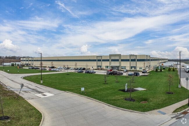
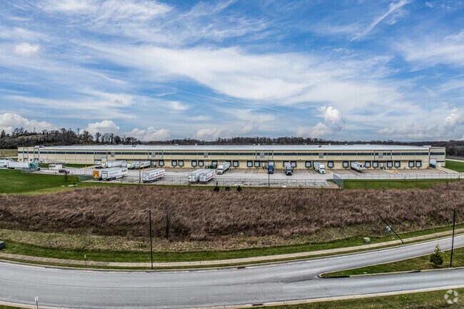
157 Starpointe Blvd
Pittsburgh, PA
Starpointe
3400360100002301
LOT 17B 38.881 AC COM BLDG
Distributionwarehouseregional
Washington
X
Pennsylvania
42125C0045E
17b
2025
38.88 AC
2025
Washington County
711000
Pittsburgh
DEMOGRAPHICS near 157 Starpointe Blvd
1 Mile
3 Mile
5 Mile
2024 Total Population
226
849
6,421
2029 Population
228
858
6,410
Pop Growth 2024-2029
+ 0.88%
+ 1.06%
(0.17%)
Average Age
47
47
45
2024 Total Households
99
372
2,765
HH Growth 2024-2029
+ 1.01%
+ 1.08%
(0.14%)
Median Household Inc
$69,642
$68,942
$65,250
Avg Household Size
2.30
2.30
2.30
2024 Avg HH Vehicles
2.00
2.00
2.00
Median Home Value
$179,999
$177,563
$156,347
Median Year Built
1990
1989
1956
Nearby Places
Map Layers
Map Styles
 Street
 Aerial
- Restaurants
- Banks
- Shops
- Fitness
- Groceries
PUBLIC TRANSPORTATION
AIRPORT
Pittsburgh International
DRIVE
WALK
Distance
Pittsburgh International
34 min
18.6 mi
Freight Ports
Port of Toledo
DRIVE
WALK
Distance
Port of Toledo
267 min
224.6 mi
Nearby Properties
Address
Land Use
TOTAL SIZE
Lot Size
Zoning
Address
Land Use
TOTAL SIZE
Lot Size
Zoning
75.99 AC
Address
Land Use
TOTAL SIZE
Lot Size
Zoning
Address
Land Use
TOTAL SIZE
Lot Size
Zoning
3,573.10 AC
Address
Land Use
TOTAL SIZE
Lot Size
Zoning
Address
Land Use
TOTAL SIZE
Lot Size
Zoning
143.60 AC
Address
Land Use
TOTAL SIZE
Lot Size
Zoning
18.08 AC
Address
Land Use
TOTAL SIZE
Lot Size
Zoning
5.74 AC
Address
Land Use
TOTAL SIZE
Lot Size
Zoning
6.33 AC
Address
Land Use
TOTAL SIZE
Lot Size
Zoning
Address
Land Use
TOTAL SIZE
Lot Size
Zoning
940.10 AC
Address
Land Use
TOTAL SIZE
Lot Size
Zoning
3.28 AC
Address
Land Use
TOTAL SIZE
Lot Size
Zoning
3.81 AC
Address
Land Use
TOTAL SIZE
Lot Size
Zoning
3.90 AC
Address
Land Use
TOTAL SIZE
Lot Size
Zoning
4.74 AC
Address
Land Use
TOTAL SIZE
Lot Size
Zoning
3.13 AC
Address
Land Use
TOTAL SIZE
Lot Size
Zoning
Address
Land Use
TOTAL SIZE
Lot Size
Zoning
Address
Land Use
TOTAL SIZE
Lot Size
Zoning
500.40 AC
Address
Land Use
TOTAL SIZE
Lot Size
Zoning
8,360 SF
34.91 AC
Address
Land Use
TOTAL SIZE
Lot Size
Zoning
Address
Land Use
TOTAL SIZE
Lot Size
Zoning
10,060 SF
22.37 AC
Address
Land Use
TOTAL SIZE
Lot Size
Zoning
1,144 SF
3.21 AC
Address
Land Use
TOTAL SIZE
Lot Size
Zoning
Address
Land Use
TOTAL SIZE
Lot Size
Zoning
8.67 AC
Address
Land Use
TOTAL SIZE
Lot Size
Zoning
Address
Land Use
TOTAL SIZE
Lot Size
Zoning
75.40 AC
Address
Land Use
TOTAL SIZE
Lot Size
Zoning
Address
Land Use
TOTAL SIZE
Lot Size
Zoning
Address
Land Use
TOTAL SIZE
Lot Size
Zoning
1,970 SF
19.55 AC
The World's #1 Commercial Real Estate Marketplace
Connect with us
© 2025 CoStar Group
The information above has been obtained from sources believed reliable. While we do not doubt its accuracy we have not verified it and make no guarantee, warranty or representation about it. It is your responsibility to independently confirm its accuracy and completeness. Any projections, opinions, assumptions, or estimates used are for example only and do not represent the current or future performance of the property. The value of this transaction to you depends on tax and other factors which should be evaluated by your tax, financial, and legal advisors. You and your advisors should conduct a careful, independent investigation of the property to determine to your satisfaction the suitability of the property for your needs.