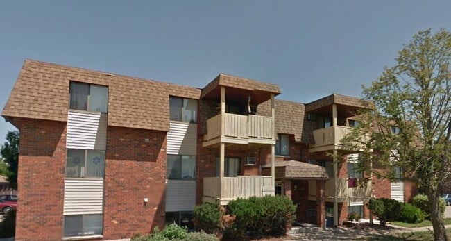
Property Record
157 W 3Rd St, Winona, MN 55987

Property Detail
157 W 3Rd St
Other Market Areas
SECT-18 TWP-107 RANGE-007 BAMBENEK-RIVERS SUBD LOT-003 BLOCK-002
Winona, MN
Winona
24.011.0190
Minnesota
Apartment
3
2026
0.20 AC
2025
Minnesota South Area
670500
NEARBY LISTINGS FOR SALE OR LEASE
-
-
View all Winona listings for sale on LoopNet.com
DEMOGRAPHICS near 157 W 3Rd St
1 mile
3 mile
5 mile
2025 Total Population
3,392
15,290
32,017
2030 Population
3,357
15,195
32,010
Pop Growth 2025-2030
(1.03%)
(0.62%)
(0.02%)
Average Age
42
40
39
2025 Total Households
1,567
6,215
13,066
HH Growth 2025-2030
(1.02%)
(0.79%)
(0.13%)
Median Household Inc
$75,391
$75,496
$59,474
Avg Household Size
2.10
2.20
2.10
2025 Avg HH Vehicles
2.00
2.00
2.00
Median Home Value
$215,726
$227,317
$212,097
Median Year Built
1984
1971
1964
Nearby Places
Map Layers
Map Styles
 Street
 Aerial
Layers
 Traffic
 Biking
Places
Listings with unknown addresses are not visible on the map
- Restaurants
- Banks
- Shops
- Fitness
- Groceries
PUBLIC TRANSPORTATION
AIRPORT
La Crosse Regional
Drive
Walk
Distance
La Crosse Regional
37 min
28.2 mi
Nearby Properties
Address
Land Use
TOTAL SIZE
Lot Size
Zoning
Address
Land Use
TOTAL SIZE
Lot Size
Zoning
93,261 SF
27.29 AC
Address
Land Use
TOTAL SIZE
Lot Size
Zoning
99,918 SF
35.30 AC
Address
Land Use
TOTAL SIZE
Lot Size
Zoning
125,217 SF
13.36 AC
Address
Land Use
TOTAL SIZE
Lot Size
Zoning
86,366 SF
7.16 AC
Address
Land Use
TOTAL SIZE
Lot Size
Zoning
139,922 SF
14.10 AC
Address
Land Use
TOTAL SIZE
Lot Size
Zoning
151,850 SF
37.50 AC
Address
Land Use
TOTAL SIZE
Lot Size
Zoning
40,985 SF
1.93 AC
Address
Land Use
TOTAL SIZE
Lot Size
Zoning
45,720 SF
4.10 AC
Address
Land Use
TOTAL SIZE
Lot Size
Zoning
135,516 SF
21.90 AC
Address
Land Use
TOTAL SIZE
Lot Size
Zoning
37,149 SF
4.90 AC
Address
Land Use
TOTAL SIZE
Lot Size
Zoning
49,336 SF
2.07 AC
Address
Land Use
TOTAL SIZE
Lot Size
Zoning
166,348 SF
7.81 AC
Address
Land Use
TOTAL SIZE
Lot Size
Zoning
37,149 SF
1.50 AC
Address
Land Use
TOTAL SIZE
Lot Size
Zoning
47,928 SF
4.37 AC
Address
Land Use
TOTAL SIZE
Lot Size
Zoning
89,010 SF
6.42 AC
Address
Land Use
TOTAL SIZE
Lot Size
Zoning
94,590 SF
3.80 AC
Address
Land Use
TOTAL SIZE
Lot Size
Zoning
244,816 SF
3.69 AC
Address
Land Use
TOTAL SIZE
Lot Size
Zoning
157,152 SF
3.92 AC
Address
Land Use
TOTAL SIZE
Lot Size
Zoning
199,094 SF
22.74 AC
Address
Land Use
TOTAL SIZE
Lot Size
Zoning
205,592 SF
19.45 AC
Address
Land Use
TOTAL SIZE
Lot Size
Zoning
157,330 SF
12.04 AC
Address
Land Use
TOTAL SIZE
Lot Size
Zoning
19,000 SF
2.07 AC
Address
Land Use
TOTAL SIZE
Lot Size
Zoning
63,868 SF
4.53 AC
Address
Land Use
TOTAL SIZE
Lot Size
Zoning
95,456 SF
0.85 AC
Address
Land Use
TOTAL SIZE
Lot Size
Zoning
20,040 SF
1.24 AC
Address
Land Use
TOTAL SIZE
Lot Size
Zoning
37,488 SF
1.78 AC
Address
Land Use
TOTAL SIZE
Lot Size
Zoning
26,864 SF
1.76 AC
Address
Land Use
TOTAL SIZE
Lot Size
Zoning
16,668 SF
2.07 AC
Address
Land Use
TOTAL SIZE
Lot Size
Zoning
162,258 SF
14.79 AC
Address
Land Use
TOTAL SIZE
Lot Size
Zoning
104,500 SF
2.30 AC
The World's #1 Commercial Real Estate Marketplace
Connect with us
© 2026 CoStar Group
The information above has been obtained from sources believed reliable. While we do not doubt its accuracy we have not verified it and make no guarantee, warranty or representation about it. It is your responsibility to independently confirm its accuracy and completeness. Any projections, opinions, assumptions, or estimates used are for example only and do not represent the current or future performance of the property. The value of this transaction to you depends on tax and other factors which should be evaluated by your tax, financial, and legal advisors. You and your advisors should conduct a careful, independent investigation of the property to determine to your satisfaction the suitability of the property for your needs.