Property Record
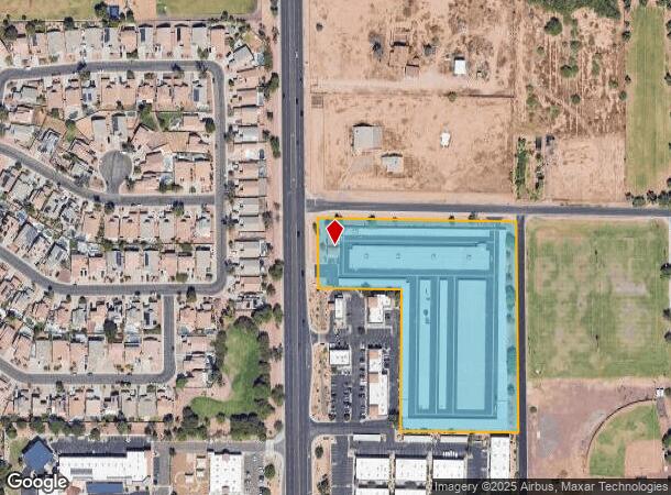
15701 N Reems Rd, Surprise, AZ 85374

NEARBY LISTINGS FOR SALE OR LEASE
-
-
View all Surprise listings for sale on LoopNet.com
Property Detail
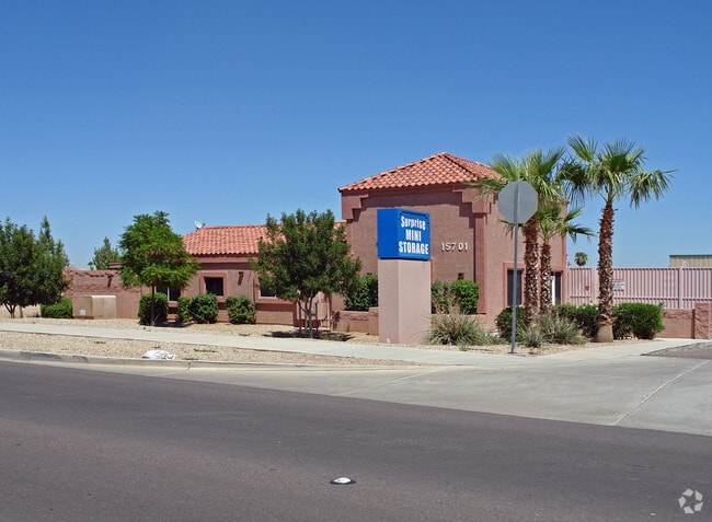
15701 N Reems Rd
Phoenix-Mesa-Scottsdale, AZ
Surprise Mini-Storage
501-17-849A
SURPRISE MINI-STORAGE MCR 617-33
Publicstorage
Maricopa
X
Arizona
04013C1220L
1
2025
6.14 AC
2025
Loop 303/Surprise
061028
Phoenix
124,448 SF
DEMOGRAPHICS near 15701 N Reems Rd
1 Mile
3 Mile
5 Mile
2024 Total Population
16,539
112,847
202,467
2029 Population
17,903
122,956
220,666
Pop Growth 2024-2029
+ 8.25%
+ 8.96%
+ 8.99%
Average Age
37
44
46
2024 Total Households
5,705
42,387
77,993
HH Growth 2024-2029
+ 8.33%
+ 9.40%
+ 9.29%
Median Household Inc
$83,343
$78,856
$74,679
Avg Household Size
2.80
2.60
2.50
2024 Avg HH Vehicles
2.00
2.00
2.00
Median Home Value
$312,552
$346,582
$342,764
Median Year Built
2003
2003
2002
Nearby Places
Map Layers
Map Styles
 Street
 Aerial
- Restaurants
- Banks
- Shops
- Fitness
- Groceries
PUBLIC TRANSPORTATION
AIRPORT
Phoenix Sky Harbor International
DRIVE
WALK
Distance
Phoenix Sky Harbor International
51 min
35.4 mi
SALE & LEASE HISTORY
LISTING DATE
SALE/LEASE

Aug 25, 2025
For Sale
Nearby Properties
Address
Land Use
TOTAL SIZE
Lot Size
Zoning
Address
Land Use
TOTAL SIZE
Lot Size
Zoning
290,294 SF
61.52 AC
PAD
Address
Land Use
TOTAL SIZE
Lot Size
Zoning
630,234 SF
27.51 AC
Address
Land Use
TOTAL SIZE
Lot Size
Zoning
575,121 SF
73.01 AC
PAD
Address
Land Use
TOTAL SIZE
Lot Size
Zoning
197,699 SF
40.78 AC
PAD
Address
Land Use
TOTAL SIZE
Lot Size
Zoning
256,094 SF
49.15 AC
PAD
Address
Land Use
TOTAL SIZE
Lot Size
Zoning
5.46 AC
Address
Land Use
TOTAL SIZE
Lot Size
Zoning
296,463 SF
12.27 AC
M-H
Address
Land Use
TOTAL SIZE
Lot Size
Zoning
539,065 SF
33.30 AC
PAD
Address
Land Use
TOTAL SIZE
Lot Size
Zoning
382,188 SF
11.17 AC
M-H
Address
Land Use
TOTAL SIZE
Lot Size
Zoning
232,202 SF
27.32 AC
PAD
Address
Land Use
TOTAL SIZE
Lot Size
Zoning
210,197 SF
19.40 AC
RH15
Address
Land Use
TOTAL SIZE
Lot Size
Zoning
67,417 SF
12.16 AC
PAD
Address
Land Use
TOTAL SIZE
Lot Size
Zoning
333,066 SF
16.33 AC
PAD
Address
Land Use
TOTAL SIZE
Lot Size
Zoning
38,400 SF
4.97 AC
I-2
Address
Land Use
TOTAL SIZE
Lot Size
Zoning
188,455 SF
17.72 AC
RH15
Address
Land Use
TOTAL SIZE
Lot Size
Zoning
90,636 SF
13.27 AC
PAD
Address
Land Use
TOTAL SIZE
Lot Size
Zoning
106,244 SF
13.55 AC
PAD
Address
Land Use
TOTAL SIZE
Lot Size
Zoning
90,387 SF
14.97 AC
PAD
Address
Land Use
TOTAL SIZE
Lot Size
Zoning
98,560 SF
12.87 AC
PAD
Address
Land Use
TOTAL SIZE
Lot Size
Zoning
236,026 SF
6.66 AC
PAD
Address
Land Use
TOTAL SIZE
Lot Size
Zoning
104,102 SF
10.81 AC
PAD
Address
Land Use
TOTAL SIZE
Lot Size
Zoning
96,782 SF
15.66 AC
PAD
Address
Land Use
TOTAL SIZE
Lot Size
Zoning
145,491 SF
37.61 AC
PAD
Address
Land Use
TOTAL SIZE
Lot Size
Zoning
104,619 SF
11.45 AC
PAD
Address
Land Use
TOTAL SIZE
Lot Size
Zoning
153,918 SF
20.58 AC
PAD
Address
Land Use
TOTAL SIZE
Lot Size
Zoning
154,628 SF
16.36 AC
PAD
Address
Land Use
TOTAL SIZE
Lot Size
Zoning
89,601 SF
19.92 AC
PAD
Address
Land Use
TOTAL SIZE
Lot Size
Zoning
65,749 SF
14.58 AC
PAD
Address
Land Use
TOTAL SIZE
Lot Size
Zoning
86,770 SF
18.26 AC
PAD
Address
Land Use
TOTAL SIZE
Lot Size
Zoning
203,123 SF
8.53 AC
PAD
The World's #1 Commercial Real Estate Marketplace
Connect with us
© 2025 CoStar Group
The information above has been obtained from sources believed reliable. While we do not doubt its accuracy we have not verified it and make no guarantee, warranty or representation about it. It is your responsibility to independently confirm its accuracy and completeness. Any projections, opinions, assumptions, or estimates used are for example only and do not represent the current or future performance of the property. The value of this transaction to you depends on tax and other factors which should be evaluated by your tax, financial, and legal advisors. You and your advisors should conduct a careful, independent investigation of the property to determine to your satisfaction the suitability of the property for your needs.