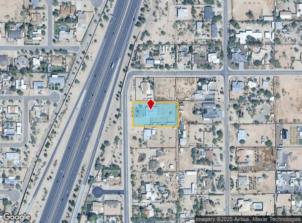
Property Record
15703 N 36Th St, Phoenix, AZ 85032
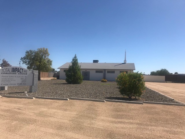
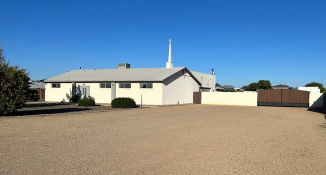
This Property Is For Sale
Current Lease Availabilities
NEARBY LISTINGS FOR SALE OR LEASE
Property Detail
15703 N 36Th St
Phoenix-Mesa-Chandler, AZ
Robinhood Acres
214-34-033A
ROBINHOOD ACRES MCR 56/30
Sfr
Maricopa
X
Arizona
04013C1295M
33
2025
1.06 AC
2025
Paradise Valley
103303
Phoenix
3,270 SF
DEMOGRAPHICS near 15703 N 36Th St
1 mile
3 mile
5 mile
2024 Total Population
16,231
140,209
281,863
2029 Population
17,490
151,456
305,453
Pop Growth 2024-2029
+ 7.76%
+ 8.02%
+ 8.37%
Average Age
38
40
41
2024 Total Households
6,407
57,336
118,262
HH Growth 2024-2029
+ 8.05%
+ 8.18%
+ 8.60%
Median Household Inc
$59,044
$75,881
$86,032
Avg Household Size
2.40
2.40
2.30
2024 Avg HH Vehicles
2.00
2.00
2.00
Median Home Value
$396,163
$402,036
$451,414
Median Year Built
1982
1985
1987
Nearby Places
Map Layers
Map Styles
 Street
 Aerial
Transit
 Traffic
 Biking
Places
Listings with unknown addresses are not visible on the map
- Restaurants
- Banks
- Shops
- Fitness
- Groceries
PUBLIC TRANSPORTATION
AIRPORT
Phoenix Sky Harbor International
Drive
Walk
Distance
Phoenix Sky Harbor International
24 min
16.8 mi
Phoenix-Mesa Gateway
Drive
Walk
Distance
Phoenix-Mesa Gateway
57 min
43.5 mi
Freight Ports
Port of San Diego
Drive
Walk
Distance
Port of San Diego
412 min
369.2 mi
Nearby Properties
Address
Land Use
TOTAL SIZE
Lot Size
Zoning
Address
Land Use
TOTAL SIZE
Lot Size
Zoning
281,880 SF
14.13 AC
Address
Land Use
TOTAL SIZE
Lot Size
Zoning
128,046 SF
9.97 AC
C2
Address
Land Use
TOTAL SIZE
Lot Size
Zoning
1,200,514 SF
47.28 AC
S1
Address
Land Use
TOTAL SIZE
Lot Size
Zoning
342,574 SF
85.69 AC
R-18
Address
Land Use
TOTAL SIZE
Lot Size
Zoning
359,170 SF
37.47 AC
R-14
Address
Land Use
TOTAL SIZE
Lot Size
Zoning
580,563 SF
9 AC
C-T
Address
Land Use
TOTAL SIZE
Lot Size
Zoning
512,499 SF
23.03 AC
R3A
Address
Land Use
TOTAL SIZE
Lot Size
Zoning
24,200 SF
2.15 AC
R-18
Address
Land Use
TOTAL SIZE
Lot Size
Zoning
482,581 SF
20.45 AC
C-C
Address
Land Use
TOTAL SIZE
Lot Size
Zoning
3.27 AC
C-C
Address
Land Use
TOTAL SIZE
Lot Size
Zoning
318,389 SF
37.57 AC
R-14
Address
Land Use
TOTAL SIZE
Lot Size
Zoning
167,532 SF
30 AC
R-14
Address
Land Use
TOTAL SIZE
Lot Size
Zoning
211,239 SF
12.33 AC
M-M
Address
Land Use
TOTAL SIZE
Lot Size
Zoning
422,509 SF
18.50 AC
C-C
Address
Land Use
TOTAL SIZE
Lot Size
Zoning
105,406 SF
22.69 AC
R-18
Address
Land Use
TOTAL SIZE
Lot Size
Zoning
28,805 SF
2.67 AC
C-C
Address
Land Use
TOTAL SIZE
Lot Size
Zoning
345,339 SF
17.01 AC
M-H
Address
Land Use
TOTAL SIZE
Lot Size
Zoning
316,766 SF
13.32 AC
M-H
Address
Land Use
TOTAL SIZE
Lot Size
Zoning
415,053 SF
6.29 AC
Address
Land Use
TOTAL SIZE
Lot Size
Zoning
127,252 SF
0.89 AC
C-C
Address
Land Use
TOTAL SIZE
Lot Size
Zoning
305,811 SF
10.44 AC
M-H
Address
Land Use
TOTAL SIZE
Lot Size
Zoning
245,623 SF
5.09 AC
I-P
Address
Land Use
TOTAL SIZE
Lot Size
Zoning
281,018 SF
9.26 AC
M-H
Address
Land Use
TOTAL SIZE
Lot Size
Zoning
14,734 SF
36.71 AC
R110
Address
Land Use
TOTAL SIZE
Lot Size
Zoning
135,939 SF
19.35 AC
R1-8
Address
Land Use
TOTAL SIZE
Lot Size
Zoning
205,996 SF
20.50 AC
PAD-MD
Address
Land Use
TOTAL SIZE
Lot Size
Zoning
113,611 SF
1.43 AC
C-C
Address
Land Use
TOTAL SIZE
Lot Size
Zoning
120,494 SF
11.17 AC
C-C
Address
Land Use
TOTAL SIZE
Lot Size
Zoning
115,983 SF
4.85 AC
R-14
Address
Land Use
TOTAL SIZE
Lot Size
Zoning
208,370 SF
19.49 AC
The World's #1 Commercial Real Estate Marketplace
Connect with us
© 2026 CoStar Group
The information above has been obtained from sources believed reliable. While we do not doubt its accuracy we have not verified it and make no guarantee, warranty or representation about it. It is your responsibility to independently confirm its accuracy and completeness. Any projections, opinions, assumptions, or estimates used are for example only and do not represent the current or future performance of the property. The value of this transaction to you depends on tax and other factors which should be evaluated by your tax, financial, and legal advisors. You and your advisors should conduct a careful, independent investigation of the property to determine to your satisfaction the suitability of the property for your needs.