Property Record
1571 Gressel Dr, Delphos, OH 45833
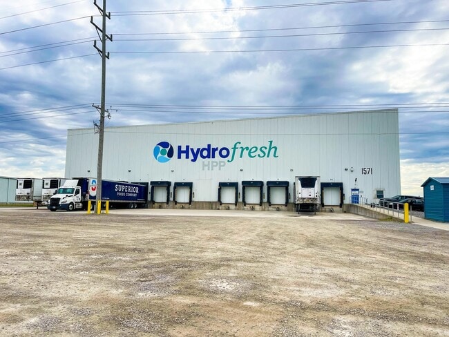

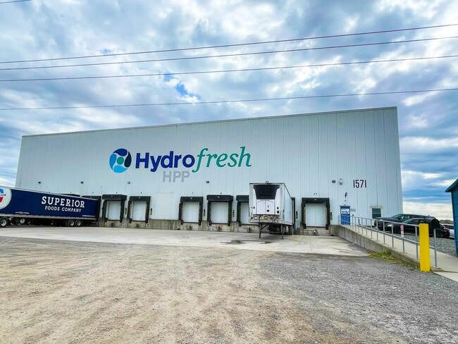
This Property Is For Sale
Property Detail
1571 Gressel Dr
25-20-00-02-003.006
PT NW1/4 SEC 20 & PT NE1/4 SEC 19 RTS 05-02-19
Industrialgeneral
ALLEN
B and X Area of moderate flood hazard, usually the area between the limits of the 100-year and 500-year floods.
Ohio
2024
3 AC
2024
Ohio North Area
014000
Other Market Areas
37,000 SF
Lima, OH
NEARBY LISTINGS FOR SALE OR LEASE
DEMOGRAPHICS near 1571 Gressel Dr
1 mile
3 mile
5 mile
2025 Total Population
1,990
8,819
11,877
2030 Population
1,957
8,789
11,822
Pop Growth 2025-2030
(1.66%)
(0.34%)
(0.46%)
Average Age
43
41
41
2025 Total Households
778
3,581
4,742
HH Growth 2025-2030
(1.67%)
(0.45%)
(0.53%)
Median Household Inc
$87,094
$67,703
$72,353
Avg Household Size
2.50
2.40
2.40
2025 Avg HH Vehicles
2.00
2.00
2.00
Median Home Value
$213,376
$162,087
$185,159
Median Year Built
1956
1958
1962
Nearby Places
Map Layers
Map Styles
 Street
 Aerial
Transit
 Traffic
 Biking
Places
Listings with unknown addresses are not visible on the map
- Restaurants
- Banks
- Shops
- Fitness
- Groceries
Nearby Properties
Address
Land Use
TOTAL SIZE
Lot Size
Zoning
Address
Land Use
TOTAL SIZE
Lot Size
Zoning
23.14 AC
Address
Land Use
TOTAL SIZE
Lot Size
Zoning
30.14 AC
Address
Land Use
TOTAL SIZE
Lot Size
Zoning
56,696 SF
8.82 AC
Address
Land Use
TOTAL SIZE
Lot Size
Zoning
25,398 SF
4.18 AC
Address
Land Use
TOTAL SIZE
Lot Size
Zoning
20.14 AC
Address
Land Use
TOTAL SIZE
Lot Size
Zoning
Address
Land Use
TOTAL SIZE
Lot Size
Zoning
143,568 SF
11.12 AC
Address
Land Use
TOTAL SIZE
Lot Size
Zoning
14.12 AC
Address
Land Use
TOTAL SIZE
Lot Size
Zoning
51,740 SF
3.25 AC
Address
Land Use
TOTAL SIZE
Lot Size
Zoning
214,230 SF
11.74 AC
Address
Land Use
TOTAL SIZE
Lot Size
Zoning
78,571 SF
10 AC
Address
Land Use
TOTAL SIZE
Lot Size
Zoning
49,121 SF
1.24 AC
Address
Land Use
TOTAL SIZE
Lot Size
Zoning
33,334 SF
18.58 AC
Address
Land Use
TOTAL SIZE
Lot Size
Zoning
108,660 SF
5.12 AC
Address
Land Use
TOTAL SIZE
Lot Size
Zoning
29,802 SF
8.14 AC
Address
Land Use
TOTAL SIZE
Lot Size
Zoning
79,000 SF
10 AC
Address
Land Use
TOTAL SIZE
Lot Size
Zoning
118,676 SF
3.94 AC
Address
Land Use
TOTAL SIZE
Lot Size
Zoning
47.58 AC
Address
Land Use
TOTAL SIZE
Lot Size
Zoning
91,400 SF
4.12 AC
Address
Land Use
TOTAL SIZE
Lot Size
Zoning
14,768 SF
7.07 AC
Address
Land Use
TOTAL SIZE
Lot Size
Zoning
Address
Land Use
TOTAL SIZE
Lot Size
Zoning
12,707 SF
2.79 AC
Address
Land Use
TOTAL SIZE
Lot Size
Zoning
11,920 SF
11.96 AC
Address
Land Use
TOTAL SIZE
Lot Size
Zoning
79,684 SF
6.28 AC
Address
Land Use
TOTAL SIZE
Lot Size
Zoning
10,103 SF
0.43 AC
Address
Land Use
TOTAL SIZE
Lot Size
Zoning
26,195 SF
1.40 AC
Address
Land Use
TOTAL SIZE
Lot Size
Zoning
44,676 SF
1.43 AC
Address
Land Use
TOTAL SIZE
Lot Size
Zoning
65,153 SF
4.98 AC
Address
Land Use
TOTAL SIZE
Lot Size
Zoning
15,530 SF
0.42 AC
The World's #1 Commercial Real Estate Marketplace
Connect with us
© 2026 CoStar Group
The information above has been obtained from sources believed reliable. While we do not doubt its accuracy we have not verified it and make no guarantee, warranty or representation about it. It is your responsibility to independently confirm its accuracy and completeness. Any projections, opinions, assumptions, or estimates used are for example only and do not represent the current or future performance of the property. The value of this transaction to you depends on tax and other factors which should be evaluated by your tax, financial, and legal advisors. You and your advisors should conduct a careful, independent investigation of the property to determine to your satisfaction the suitability of the property for your needs.