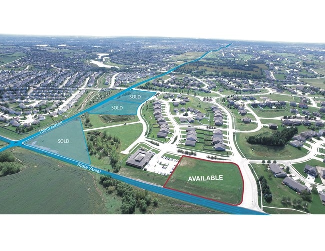
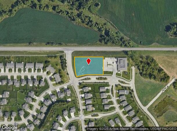
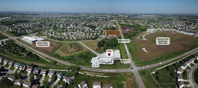
Property Record
15710 Grebe St, Bennington, NE 68007
NEARBY LISTINGS FOR SALE OR LEASE
Property Detail
15710 Grebe St
Omaha-Council Bluffs, NE-IA
Pine Creek
1214-7210-20
PINE CREEK REPLAT FIVE LOT 1 BLOCK 0 LT 1 52820 SQ FT
Commercialnec
Douglas
X
Nebraska
31055C0183J
1
2024
1.21 AC
2025
Northwest Omaha
007318
Omaha/Council Bluffs
DEMOGRAPHICS near 15710 Grebe St
1 Mile
3 Mile
5 Mile
2024 Total Population
8,906
45,756
111,620
2029 Population
9,375
47,151
113,877
Pop Growth 2024-2029
+ 5.27%
+ 3.05%
+ 2.02%
Average Age
33
37
38
2024 Total Households
2,735
16,289
41,353
HH Growth 2024-2029
+ 5.19%
+ 2.86%
+ 1.92%
Median Household Inc
$121,620
$114,994
$103,631
Avg Household Size
3.20
2.80
2.70
2024 Avg HH Vehicles
2.00
2.00
2.00
Median Home Value
$344,263
$305,807
$281,802
Median Year Built
2010
2007
2000
Nearby Places
Map Layers
Map Styles
 Street
 Aerial
- Restaurants
- Banks
- Shops
- Fitness
- Groceries
PUBLIC TRANSPORTATION
AIRPORT
Eppley Airfield
DRIVE
WALK
Distance
Eppley Airfield
32 min
17.2 mi
Freight Ports
Tulsa Port Of Catoosa
DRIVE
WALK
Distance
Tulsa Port Of Catoosa
487 min
435.4 mi
SALE & LEASE HISTORY
LISTING DATE
SALE/LEASE

Nov 26, 2018
For Sale
Nov 06, 2019
For Sale
Nearby Properties
Address
Land Use
TOTAL SIZE
Lot Size
Zoning
Address
Land Use
TOTAL SIZE
Lot Size
Zoning
396,428 SF
14.45 AC
R6
Address
Land Use
TOTAL SIZE
Lot Size
Zoning
311,856 SF
19.22 AC
Address
Land Use
TOTAL SIZE
Lot Size
Zoning
339,557 SF
12.89 AC
R7
Address
Land Use
TOTAL SIZE
Lot Size
Zoning
350,925 SF
12.71 AC
Address
Land Use
TOTAL SIZE
Lot Size
Zoning
320,111 SF
19.17 AC
R4
Address
Land Use
TOTAL SIZE
Lot Size
Zoning
301,689 SF
8.82 AC
Address
Land Use
TOTAL SIZE
Lot Size
Zoning
261,247 SF
13.20 AC
Address
Land Use
TOTAL SIZE
Lot Size
Zoning
228,963 SF
7.36 AC
Address
Land Use
TOTAL SIZE
Lot Size
Zoning
149,081 SF
9.01 AC
Address
Land Use
TOTAL SIZE
Lot Size
Zoning
189,099 SF
7.13 AC
Address
Land Use
TOTAL SIZE
Lot Size
Zoning
166,080 SF
6.25 AC
R6
Address
Land Use
TOTAL SIZE
Lot Size
Zoning
207,693 SF
21.62 AC
MU
Address
Land Use
TOTAL SIZE
Lot Size
Zoning
137,022 SF
5.83 AC
R6
Address
Land Use
TOTAL SIZE
Lot Size
Zoning
121,376 SF
4.21 AC
Address
Land Use
TOTAL SIZE
Lot Size
Zoning
95,756 SF
2.96 AC
Address
Land Use
TOTAL SIZE
Lot Size
Zoning
106,465 SF
11.11 AC
Address
Land Use
TOTAL SIZE
Lot Size
Zoning
80,791 SF
3.92 AC
R6
Address
Land Use
TOTAL SIZE
Lot Size
Zoning
37,829 SF
3.80 AC
MU
Address
Land Use
TOTAL SIZE
Lot Size
Zoning
79,669 SF
4.75 AC
MU
Address
Land Use
TOTAL SIZE
Lot Size
Zoning
44,516 SF
5.40 AC
MU
Address
Land Use
TOTAL SIZE
Lot Size
Zoning
56,838 SF
2.42 AC
Address
Land Use
TOTAL SIZE
Lot Size
Zoning
93,360 SF
5.40 AC
MU
Address
Land Use
TOTAL SIZE
Lot Size
Zoning
10,638 SF
2.10 AC
MU
Address
Land Use
TOTAL SIZE
Lot Size
Zoning
146,652 SF
7.24 AC
Address
Land Use
TOTAL SIZE
Lot Size
Zoning
94,236 SF
3.09 AC
Address
Land Use
TOTAL SIZE
Lot Size
Zoning
27,059 SF
2.79 AC
MU
Address
Land Use
TOTAL SIZE
Lot Size
Zoning
50,125 SF
4.43 AC
MU
Address
Land Use
TOTAL SIZE
Lot Size
Zoning
24,066 SF
2.41 AC
Address
Land Use
TOTAL SIZE
Lot Size
Zoning
50,873 SF
3.19 AC
R6
Address
Land Use
TOTAL SIZE
Lot Size
Zoning
21,326 SF
3.39 AC
The World's #1 Commercial Real Estate Marketplace
Connect with us
© 2025 CoStar Group
The information above has been obtained from sources believed reliable. While we do not doubt its accuracy we have not verified it and make no guarantee, warranty or representation about it. It is your responsibility to independently confirm its accuracy and completeness. Any projections, opinions, assumptions, or estimates used are for example only and do not represent the current or future performance of the property. The value of this transaction to you depends on tax and other factors which should be evaluated by your tax, financial, and legal advisors. You and your advisors should conduct a careful, independent investigation of the property to determine to your satisfaction the suitability of the property for your needs.