Property Record
15717 Clear Spring Rd, Williamsport, MD 21795

Save to a Folder
{{folder.Name}}
{{folder.ListingIds.length}} Properties
{{folder.ListingIds.length}} Property
Create a New Folder
Current Lease Availabilities
Property Detail
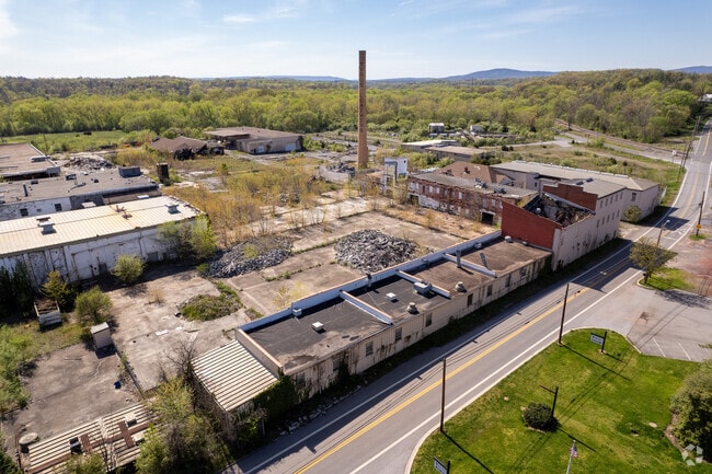
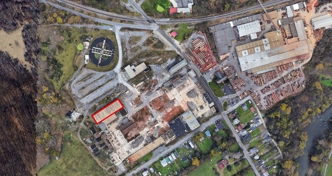
15717 Clear Spring Rd
02-002221
16.74 ACRES 15717 CLEAR SPRING ROAD TANNERY SITE
Industrialgeneral
Washington
ORI
Maryland
AE The base floodplain where base flood elevations are provided. AE Zones are now used on new format FIRMs instead of A1-A30 Zones.
16.74 AC
2025
Washington County
2025
Washington, DC
011700
Hagerstown-Martinsburg, MD-WV
374,245 SF
NEARBY LISTINGS FOR SALE OR LEASE
DEMOGRAPHICS near 15717 Clear Spring Rd
1 mile
3 mile
5 mile
2025 Total Population
2,977
15,418
36,779
2030 Population
3,013
16,003
38,187
Pop Growth 2025-2030
+ 1.21%
+ 3.79%
+ 3.83%
Average Age
44
43
42
2025 Total Households
1,281
6,160
14,347
HH Growth 2025-2030
+ 1.25%
+ 3.83%
+ 3.79%
Median Household Inc
$67,187
$74,524
$77,570
Avg Household Size
2.20
2.40
2.50
2025 Avg HH Vehicles
2.00
2.00
2.00
Median Home Value
$234,536
$253,855
$269,825
Median Year Built
1960
1983
1980
Nearby Places
Map Layers
Map Styles
 Street
 Aerial
Layers
 Traffic
 Biking
Places
Listings with unknown addresses are not visible on the map
- Restaurants
- Banks
- Shops
- Fitness
- Groceries
PUBLIC TRANSPORTATION
AIRPORT
Hagerstown Regional/Richard A Henson Field
Drive
Walk
Distance
Hagerstown Regional/Richard A Henson Field
17 min
10.7 mi
Nearby Properties
Address
Land Use
TOTAL SIZE
Lot Size
Zoning
Address
Land Use
TOTAL SIZE
Lot Size
Zoning
825,620 SF
53.74 AC
IG
Address
Land Use
TOTAL SIZE
Lot Size
Zoning
157,680 SF
69.83 AC
HI
Address
Land Use
TOTAL SIZE
Lot Size
Zoning
591,555 SF
114.50 AC
HI
Address
Land Use
TOTAL SIZE
Lot Size
Zoning
153,846 SF
110.85 AC
U
Address
Land Use
TOTAL SIZE
Lot Size
Zoning
1,021,162 SF
117.63 AC
HI
Address
Land Use
TOTAL SIZE
Lot Size
Zoning
824,298 SF
70.25 AC
HI
Address
Land Use
TOTAL SIZE
Lot Size
Zoning
294,240 SF
43.79 AC
HI
Address
Land Use
TOTAL SIZE
Lot Size
Zoning
161,172 SF
19.70 AC
HI
Address
Land Use
TOTAL SIZE
Lot Size
Zoning
506,003 SF
40 AC
HI
Address
Land Use
TOTAL SIZE
Lot Size
Zoning
486,861 SF
35.40 AC
HI
Address
Land Use
TOTAL SIZE
Lot Size
Zoning
231,293 SF
16.93 AC
PI
Address
Land Use
TOTAL SIZE
Lot Size
Zoning
88,042 SF
9.98 AC
RT
Address
Land Use
TOTAL SIZE
Lot Size
Zoning
36,000 SF
23.49 AC
HI
Address
Land Use
TOTAL SIZE
Lot Size
Zoning
9,918 SF
17 AC
IG
Address
Land Use
TOTAL SIZE
Lot Size
Zoning
2,324 SF
6 AC
TR
Address
Land Use
TOTAL SIZE
Lot Size
Zoning
924 SF
67.86 AC
RU
Address
Land Use
TOTAL SIZE
Lot Size
Zoning
7,943 SF
26.33 AC
HI
Address
Land Use
TOTAL SIZE
Lot Size
Zoning
2,723 SF
89.57 AC
RB-E
Address
Land Use
TOTAL SIZE
Lot Size
Zoning
32,788 SF
22.20 AC
PI
Address
Land Use
TOTAL SIZE
Lot Size
Zoning
120 SF
8.97 AC
RM
Address
Land Use
TOTAL SIZE
Lot Size
Zoning
247,962 SF
14.66 AC
PI
Address
Land Use
TOTAL SIZE
Lot Size
Zoning
327,100 SF
41.81 AC
PI
Address
Land Use
TOTAL SIZE
Lot Size
Zoning
40 AC
HI
Address
Land Use
TOTAL SIZE
Lot Size
Zoning
12,144 SF
8.30 AC
U
Address
Land Use
TOTAL SIZE
Lot Size
Zoning
104,710 SF
8.81 AC
BG
Address
Land Use
TOTAL SIZE
Lot Size
Zoning
220,800 SF
20.54 AC
IG
Address
Land Use
TOTAL SIZE
Lot Size
Zoning
61,205 SF
9.13 AC
HI
Address
Land Use
TOTAL SIZE
Lot Size
Zoning
1,512 SF
44.61 AC
RU
Address
Land Use
TOTAL SIZE
Lot Size
Zoning
85,429 SF
15.37 AC
PI
Address
Land Use
TOTAL SIZE
Lot Size
Zoning
88,407 SF
9.82 AC
BG
The World's #1 Commercial Real Estate Marketplace
Connect with us
© 2026 CoStar Group
The information above has been obtained from sources believed reliable. While we do not doubt its accuracy we have not verified it and make no guarantee, warranty or representation about it. It is your responsibility to independently confirm its accuracy and completeness. Any projections, opinions, assumptions, or estimates used are for example only and do not represent the current or future performance of the property. The value of this transaction to you depends on tax and other factors which should be evaluated by your tax, financial, and legal advisors. You and your advisors should conduct a careful, independent investigation of the property to determine to your satisfaction the suitability of the property for your needs.