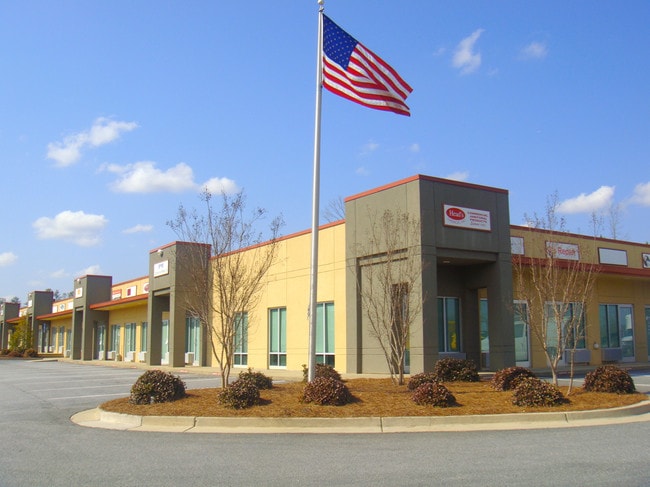
Property Record
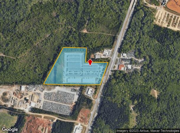
1572 Highway 85 N, Fayetteville, GA 30214
Current Lease Availabilities
NEARBY LISTINGS FOR SALE OR LEASE
Property Detail
1572 Highway 85 N
Atlanta-Sandy Springs-Roswell, GA
Storage Xxtra Hwy 85 Llc
05-45-00-015
HWY 85
Publicstorage
Fayette
X
Georgia
13063C0131F
200
0
19.59 AC
2024
Fayette/Coweta County
140102
Atlanta
199,132 SF
DEMOGRAPHICS near 1572 Highway 85 N
1 Mile
3 Mile
5 Mile
2024 Total Population
623
34,546
111,042
2029 Population
657
35,396
113,171
Pop Growth 2024-2029
+ 5.46%
+ 2.46%
+ 1.92%
Average Age
44
40
39
2024 Total Households
226
12,402
39,368
HH Growth 2024-2029
+ 5.75%
+ 2.58%
+ 2.01%
Median Household Inc
$69,599
$63,355
$63,559
Avg Household Size
2.60
2.70
2.70
2024 Avg HH Vehicles
3.00
2.00
2.00
Median Home Value
$259,523
$232,096
$229,453
Median Year Built
1984
1986
1989
Nearby Places
- Restaurants
- Banks
- Shops
- Fitness
- Groceries
PUBLIC TRANSPORTATION
AIRPORT
Hartsfield - Jackson Atlanta International
DRIVE
WALK
Distance
Hartsfield - Jackson Atlanta International
24 min
13.2 mi
Freight Ports
Georgia Ports - Savannah
DRIVE
WALK
Distance
Georgia Ports - Savannah
277 min
238.7 mi
Nearby Properties
Address
Land Use
TOTAL SIZE
Lot Size
Zoning
Address
Land Use
TOTAL SIZE
Lot Size
Zoning
7,851 SF
94.84 AC
RS180
Address
Land Use
TOTAL SIZE
Lot Size
Zoning
88,509 SF
31.54 AC
C C3
Address
Land Use
TOTAL SIZE
Lot Size
Zoning
230,474 SF
288.50 AC
PCD
Address
Land Use
TOTAL SIZE
Lot Size
Zoning
80,942 SF
44.16 AC
C CH
Address
Land Use
TOTAL SIZE
Lot Size
Zoning
256 SF
25 AC
PUD
Address
Land Use
TOTAL SIZE
Lot Size
Zoning
232,852 SF
35.39 AC
C C3
Address
Land Use
TOTAL SIZE
Lot Size
Zoning
260,883 SF
21.30 AC
C C3
Address
Land Use
TOTAL SIZE
Lot Size
Zoning
160 SF
19.95 AC
RM
Address
Land Use
TOTAL SIZE
Lot Size
Zoning
132,197 SF
18 AC
C RMF15
Address
Land Use
TOTAL SIZE
Lot Size
Zoning
176 SF
17.67 AC
RM
Address
Land Use
TOTAL SIZE
Lot Size
Zoning
210,122 SF
16.77 AC
C C3
Address
Land Use
TOTAL SIZE
Lot Size
Zoning
184,862 SF
21.90 AC
C C3
Address
Land Use
TOTAL SIZE
Lot Size
Zoning
141,792 SF
18.50 AC
RS110
Address
Land Use
TOTAL SIZE
Lot Size
Zoning
127,836 SF
14.33 AC
C CH
Address
Land Use
TOTAL SIZE
Lot Size
Zoning
136,320 SF
19.51 AC
C C3
Address
Land Use
TOTAL SIZE
Lot Size
Zoning
Address
Land Use
TOTAL SIZE
Lot Size
Zoning
65,951 SF
6.70 AC
C C3
Address
Land Use
TOTAL SIZE
Lot Size
Zoning
75,750 SF
10.43 AC
C C3
Address
Land Use
TOTAL SIZE
Lot Size
Zoning
73,040 SF
6.01 AC
C RMF15
Address
Land Use
TOTAL SIZE
Lot Size
Zoning
25,980 SF
199.40 AC
Address
Land Use
TOTAL SIZE
Lot Size
Zoning
108 SF
10.82 AC
RM
Address
Land Use
TOTAL SIZE
Lot Size
Zoning
63,428 SF
7.92 AC
C OI
Address
Land Use
TOTAL SIZE
Lot Size
Zoning
71,768 SF
8.58 AC
C C3
Address
Land Use
TOTAL SIZE
Lot Size
Zoning
57,441 SF
15.20 AC
RS110
Address
Land Use
TOTAL SIZE
Lot Size
Zoning
67,000 SF
6.39 AC
I M1
Address
Land Use
TOTAL SIZE
Lot Size
Zoning
35,672 SF
3.33 AC
C CH
Address
Land Use
TOTAL SIZE
Lot Size
Zoning
114,926 SF
9.30 AC
C C3
Address
Land Use
TOTAL SIZE
Lot Size
Zoning
1,800 SF
169.19 AC
AR
Address
Land Use
TOTAL SIZE
Lot Size
Zoning
1,656 SF
21.85 AC
RS110
The World's #1 Commercial Real Estate Marketplace
Connect with us
© 2025 CoStar Group
The information above has been obtained from sources believed reliable. While we do not doubt its accuracy we have not verified it and make no guarantee, warranty or representation about it. It is your responsibility to independently confirm its accuracy and completeness. Any projections, opinions, assumptions, or estimates used are for example only and do not represent the current or future performance of the property. The value of this transaction to you depends on tax and other factors which should be evaluated by your tax, financial, and legal advisors. You and your advisors should conduct a careful, independent investigation of the property to determine to your satisfaction the suitability of the property for your needs.