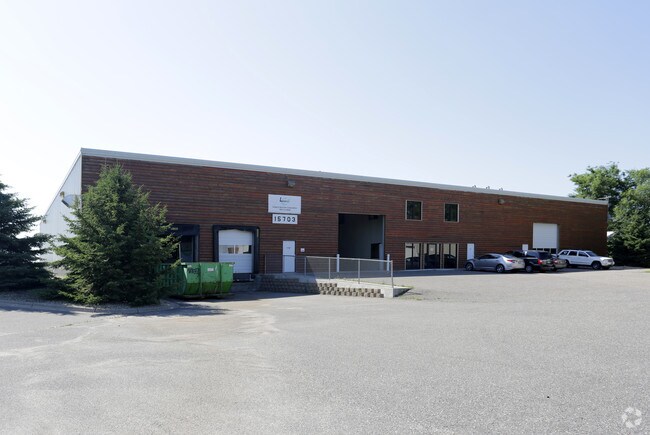
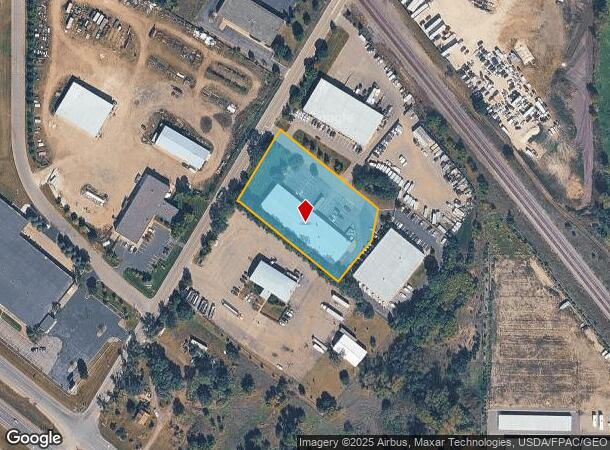
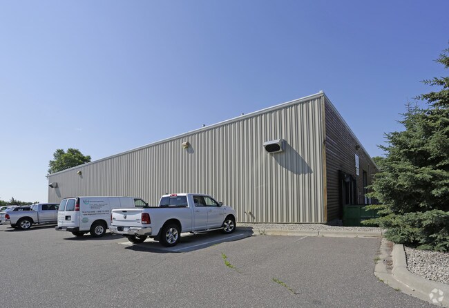
Property Record
15725 Jarvis St Nw, Elk River, MN 55330
NEARBY LISTINGS FOR SALE OR LEASE
Property Detail
15725 Jarvis St Nw
Minneapolis-St. Paul-Bloomington, MN-WI
Ar-Mon Commercial Park Second Add
75-805-0115
LOT 3, BLK 1
Industrialgeneral
Sherburne
X
Minnesota
27003C0144E
3
2025
1.89 AC
2025
Sherburne County
030505
Minneapolis/St Paul
2,400 SF
DEMOGRAPHICS near 15725 Jarvis St Nw
1 Mile
3 Mile
5 Mile
2024 Total Population
819
18,663
58,937
2029 Population
854
20,469
63,228
Pop Growth 2024-2029
+ 4.27%
+ 9.68%
+ 7.28%
Average Age
41
38
38
2024 Total Households
286
6,733
21,041
HH Growth 2024-2029
+ 4.55%
+ 9.82%
+ 7.46%
Median Household Inc
$159,524
$109,224
$103,560
Avg Household Size
2.80
2.70
2.70
2024 Avg HH Vehicles
2.00
2.00
2.00
Median Home Value
$452,659
$329,729
$328,289
Median Year Built
1997
2004
2000
Nearby Places
- Restaurants
- Banks
- Shops
- Fitness
- Groceries
PUBLIC TRANSPORTATION
COMMUTER RAIL
Elk River Station (Northstar Corridor - Northstar Commuter Rail)
DRIVE
WALK
Distance
Elk River Station (Northstar Corridor - Northstar Commuter Rail)
5 min
3.3 mi
Anoka Station (Northstar Corridor - Northstar Commuter Rail)
DRIVE
WALK
Distance
Anoka Station (Northstar Corridor - Northstar Commuter Rail)
14 min
8.7 mi
AIRPORT
Minneapolis-St Paul International/Wold-Chamberlain
DRIVE
WALK
Distance
Minneapolis-St Paul International/Wold-Chamberlain
47 min
41.6 mi
Freight Ports
Port of Shreveport
DRIVE
WALK
Distance
Port of Shreveport
1 min
891.4 mi
SALE & LEASE HISTORY
LISTING DATE
SALE/LEASE

Sep 24, 2016
For Sale
Nearby Properties
Address
Land Use
TOTAL SIZE
Lot Size
Zoning
Address
Land Use
TOTAL SIZE
Lot Size
Zoning
3,491 SF
3.03 AC
Address
Land Use
TOTAL SIZE
Lot Size
Zoning
706,604 SF
30.67 AC
Address
Land Use
TOTAL SIZE
Lot Size
Zoning
68,362 SF
Address
Land Use
TOTAL SIZE
Lot Size
Zoning
401,188 SF
20.74 AC
Address
Land Use
TOTAL SIZE
Lot Size
Zoning
163,282 SF
5.25 AC
Address
Land Use
TOTAL SIZE
Lot Size
Zoning
229,457 SF
16.04 AC
Address
Land Use
TOTAL SIZE
Lot Size
Zoning
148,214 SF
8.73 AC
Address
Land Use
TOTAL SIZE
Lot Size
Zoning
299,904 SF
18.63 AC
Address
Land Use
TOTAL SIZE
Lot Size
Zoning
267,924 SF
13.88 AC
Address
Land Use
TOTAL SIZE
Lot Size
Zoning
147,000 SF
Address
Land Use
TOTAL SIZE
Lot Size
Zoning
147,000 SF
Address
Land Use
TOTAL SIZE
Lot Size
Zoning
103,080 SF
5.47 AC
Address
Land Use
TOTAL SIZE
Lot Size
Zoning
212,224 SF
12.84 AC
Address
Land Use
TOTAL SIZE
Lot Size
Zoning
111,300 SF
Address
Land Use
TOTAL SIZE
Lot Size
Zoning
113 SF
8.08 AC
Address
Land Use
TOTAL SIZE
Lot Size
Zoning
113 SF
5.30 AC
Address
Land Use
TOTAL SIZE
Lot Size
Zoning
176,540 SF
14.08 AC
Address
Land Use
TOTAL SIZE
Lot Size
Zoning
90,810 SF
14.19 AC
Address
Land Use
TOTAL SIZE
Lot Size
Zoning
102,938 SF
Address
Land Use
TOTAL SIZE
Lot Size
Zoning
Address
Land Use
TOTAL SIZE
Lot Size
Zoning
59,298 SF
9.58 AC
Address
Land Use
TOTAL SIZE
Lot Size
Zoning
154,800 SF
8.74 AC
Address
Land Use
TOTAL SIZE
Lot Size
Zoning
7,280 SF
40.06 AC
Address
Land Use
TOTAL SIZE
Lot Size
Zoning
85,493 SF
46.22 AC
Address
Land Use
TOTAL SIZE
Lot Size
Zoning
64,000 SF
4.52 AC
Address
Land Use
TOTAL SIZE
Lot Size
Zoning
1,720 SF
4.56 AC
Address
Land Use
TOTAL SIZE
Lot Size
Zoning
67,500 SF
6.28 AC
Address
Land Use
TOTAL SIZE
Lot Size
Zoning
60,800 SF
5.74 AC
Address
Land Use
TOTAL SIZE
Lot Size
Zoning
100,134 SF
10.36 AC
Address
Land Use
TOTAL SIZE
Lot Size
Zoning
The World's #1 Commercial Real Estate Marketplace
Connect with us
© 2025 CoStar Group
The information above has been obtained from sources believed reliable. While we do not doubt its accuracy we have not verified it and make no guarantee, warranty or representation about it. It is your responsibility to independently confirm its accuracy and completeness. Any projections, opinions, assumptions, or estimates used are for example only and do not represent the current or future performance of the property. The value of this transaction to you depends on tax and other factors which should be evaluated by your tax, financial, and legal advisors. You and your advisors should conduct a careful, independent investigation of the property to determine to your satisfaction the suitability of the property for your needs.