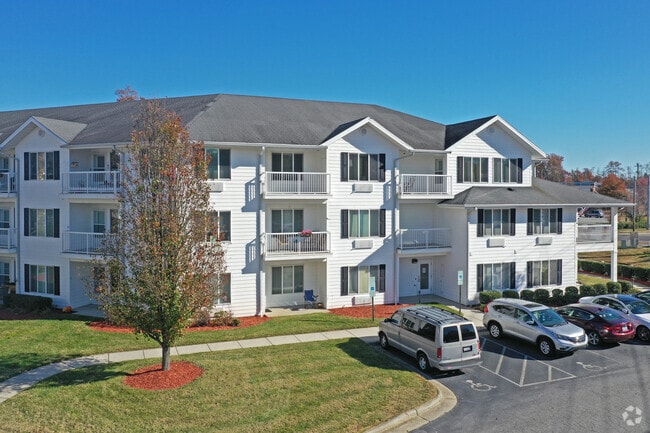
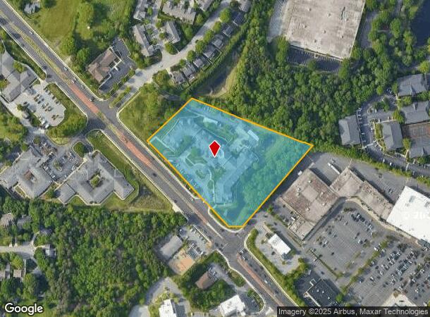
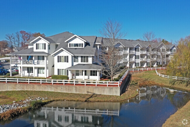
Property Record
1573 Skeet Club Rd, High Point, NC 27265
NEARBY LISTINGS FOR SALE OR LEASE
-
-
View all High Point listings for sale on LoopNet.com
Property Detail
1573 Skeet Club Rd
Greensboro-High Point, NC
C Elizabeth Jones Torrence Et
0204495
1573 SKEET CL LO:2 PL:142-43
Retirementnursinghomecombined
Guilford
X
North Carolina
3710781300J
2
2024
5.11 AC
2025
Jamestown/High Point
016205
Greensboro/Winston-Salem
100,921 SF
DEMOGRAPHICS near 1573 Skeet Club Rd
1 Mile
3 Mile
5 Mile
2024 Total Population
7,714
40,046
115,290
2029 Population
7,646
39,888
115,366
Pop Growth 2024-2029
(0.88%)
(0.39%)
+ 0.07%
Average Age
41
41
40
2024 Total Households
3,235
16,333
47,009
HH Growth 2024-2029
(0.90%)
(0.48%)
+ 0.04%
Median Household Inc
$74,682
$84,180
$65,758
Avg Household Size
2.40
2.40
2.30
2024 Avg HH Vehicles
2.00
2.00
2.00
Median Home Value
$232,517
$248,895
$203,727
Median Year Built
1998
1997
1992
Nearby Places
Map Layers
Map Styles
 Street
 Aerial
- Restaurants
- Banks
- Shops
- Fitness
- Groceries
PUBLIC TRANSPORTATION
COMMUTER RAIL
High Point Station (Piedmont - North Carolina by Train (NC Train))
DRIVE
WALK
Distance
High Point Station (Piedmont - North Carolina by Train (NC Train))
13 min
6.8 mi
AIRPORT
Piedmont Triad International
DRIVE
WALK
Distance
Piedmont Triad International
18 min
7.4 mi
Nearby Properties
Address
Land Use
TOTAL SIZE
Lot Size
Zoning
Address
Land Use
TOTAL SIZE
Lot Size
Zoning
37,237 SF
334.45 AC
HI
Address
Land Use
TOTAL SIZE
Lot Size
Zoning
256,051 SF
37.69 AC
LI
Address
Land Use
TOTAL SIZE
Lot Size
Zoning
691,408 SF
58.69 AC
LI
Address
Land Use
TOTAL SIZE
Lot Size
Zoning
552,314 SF
38.47 AC
PDR
Address
Land Use
TOTAL SIZE
Lot Size
Zoning
400,000 SF
46.72 AC
LI
Address
Land Use
TOTAL SIZE
Lot Size
Zoning
354,454 SF
20.65 AC
RM-18
Address
Land Use
TOTAL SIZE
Lot Size
Zoning
229,103 SF
18.76 AC
CZ-I
Address
Land Use
TOTAL SIZE
Lot Size
Zoning
291,895 SF
21.52 AC
RM-26
Address
Land Use
TOTAL SIZE
Lot Size
Zoning
363,308 SF
29.41 AC
RM-16
Address
Land Use
TOTAL SIZE
Lot Size
Zoning
309,749 SF
16.74 AC
CZ-PDM
Address
Land Use
TOTAL SIZE
Lot Size
Zoning
53,362 SF
0.51 AC
LAR3
Address
Land Use
TOTAL SIZE
Lot Size
Zoning
274,999 SF
21.57 AC
LI
Address
Land Use
TOTAL SIZE
Lot Size
Zoning
214,941 SF
13.29 AC
PDR
Address
Land Use
TOTAL SIZE
Lot Size
Zoning
299,786 SF
24.49 AC
PDP
Address
Land Use
TOTAL SIZE
Lot Size
Zoning
227,652 SF
21.64 AC
LI
Address
Land Use
TOTAL SIZE
Lot Size
Zoning
240,936 SF
12.02 AC
PDM
Address
Land Use
TOTAL SIZE
Lot Size
Zoning
269,956 SF
19.44 AC
OI
Address
Land Use
TOTAL SIZE
Lot Size
Zoning
209,184 SF
13.52 AC
OI
Address
Land Use
TOTAL SIZE
Lot Size
Zoning
75,588 SF
6.49 AC
LI
Address
Land Use
TOTAL SIZE
Lot Size
Zoning
760,545 SF
69.50 AC
LI
Address
Land Use
TOTAL SIZE
Lot Size
Zoning
176,000 SF
12.95 AC
CZ-I
Address
Land Use
TOTAL SIZE
Lot Size
Zoning
1.32 AC
PNR
Address
Land Use
TOTAL SIZE
Lot Size
Zoning
304,447 SF
27.69 AC
RM-16
Address
Land Use
TOTAL SIZE
Lot Size
Zoning
342,988 SF
29.36 AC
LI
Address
Land Use
TOTAL SIZE
Lot Size
Zoning
128,435 SF
10.40 AC
LI
Address
Land Use
TOTAL SIZE
Lot Size
Zoning
361,412 SF
35.81 AC
LI
Address
Land Use
TOTAL SIZE
Lot Size
Zoning
311,785 SF
107.44 AC
PI
Address
Land Use
TOTAL SIZE
Lot Size
Zoning
233,893 SF
51.31 AC
LI
Address
Land Use
TOTAL SIZE
Lot Size
Zoning
99,998 SF
12.44 AC
LI
Address
Land Use
TOTAL SIZE
Lot Size
Zoning
266,881 SF
29.68 AC
AG
The World's #1 Commercial Real Estate Marketplace
Connect with us
© 2026 CoStar Group
The information above has been obtained from sources believed reliable. While we do not doubt its accuracy we have not verified it and make no guarantee, warranty or representation about it. It is your responsibility to independently confirm its accuracy and completeness. Any projections, opinions, assumptions, or estimates used are for example only and do not represent the current or future performance of the property. The value of this transaction to you depends on tax and other factors which should be evaluated by your tax, financial, and legal advisors. You and your advisors should conduct a careful, independent investigation of the property to determine to your satisfaction the suitability of the property for your needs.