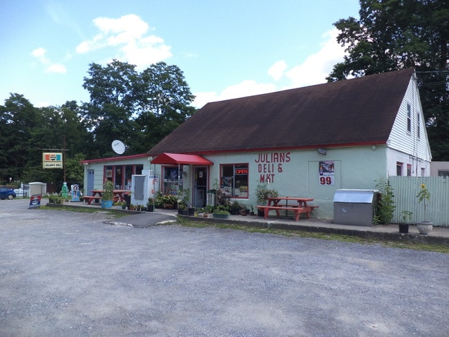
Property Record
1574 Route 9G, Hyde Park, NY 12538
NEARBY LISTINGS FOR SALE OR LEASE
Property Detail
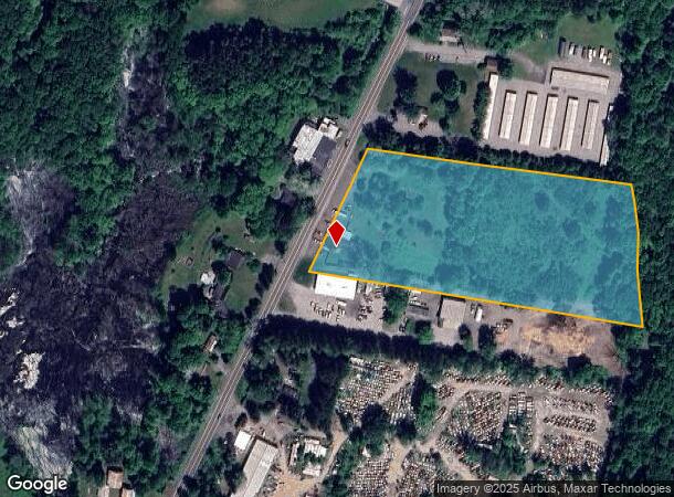
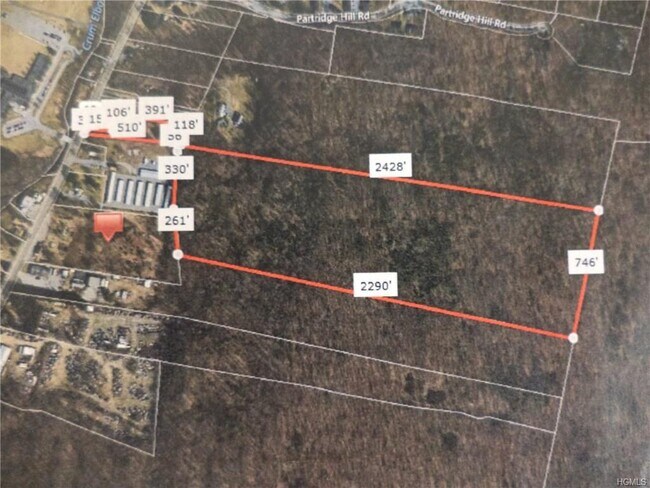
1574 Route 9G
133200-6166-04-780316-0000
6.437 AC 1591 0225 0671 0017
Commercialnec
Dutchess
X
New York
36027C0259E
780
2025
6.43 AC
2024
Fishkill
070102
Westchester/So Connecticut
3,544 SF
Dutchess County-Putnam County, NY
DEMOGRAPHICS near 1574 Route 9G
1 Mile
3 Mile
5 Mile
2024 Total Population
1,303
11,122
22,451
2029 Population
1,308
11,159
22,444
Pop Growth 2024-2029
+ 0.38%
+ 0.33%
(0.03%)
Average Age
44
45
44
2024 Total Households
510
4,514
8,696
HH Growth 2024-2029
+ 0.39%
+ 0.33%
(0.06%)
Median Household Inc
$90,719
$79,963
$87,667
Avg Household Size
2.40
2.30
2.30
2024 Avg HH Vehicles
2.00
2.00
2.00
Median Home Value
$311,735
$284,693
$298,071
Median Year Built
1974
1972
1970
Nearby Places
- Restaurants
- Banks
- Shops
- Fitness
- Groceries
PUBLIC TRANSPORTATION
AIRPORT
New York Stewart International
DRIVE
WALK
Distance
New York Stewart International
48 min
32.7 mi
Freight Ports
Albany, NY Port
DRIVE
WALK
Distance
Albany, NY Port
87 min
62.3 mi
SALE & LEASE HISTORY
LISTING DATE
SALE/LEASE

Sep 11, 2017
For Sale
Oct 03, 2017
For Sale
Nov 01, 2017
For Sale
May 01, 2019
For Sale
Jul 21, 2017
For Sale
Feb 19, 2019
For Sale
Aug 23, 2020
For Sale
Nearby Properties
Address
Land Use
TOTAL SIZE
Lot Size
Zoning
Address
Land Use
TOTAL SIZE
Lot Size
Zoning
250,645 SF
65 AC
GB
Address
Land Use
TOTAL SIZE
Lot Size
Zoning
23,195 SF
142.20 AC
RF1
Address
Land Use
TOTAL SIZE
Lot Size
Zoning
53,841 SF
195.70 AC
WF
Address
Land Use
TOTAL SIZE
Lot Size
Zoning
64,945 SF
104.77 AC
GB
Address
Land Use
TOTAL SIZE
Lot Size
Zoning
59,188 SF
75.08 AC
GB
Address
Land Use
TOTAL SIZE
Lot Size
Zoning
46,148 SF
22.90 AC
RA
Address
Land Use
TOTAL SIZE
Lot Size
Zoning
24,956 SF
100 AC
WF
Address
Land Use
TOTAL SIZE
Lot Size
Zoning
47,524 SF
13 AC
N
Address
Land Use
TOTAL SIZE
Lot Size
Zoning
80,688 SF
86.88 AC
WF
Address
Land Use
TOTAL SIZE
Lot Size
Zoning
21,464 SF
7.69 AC
EPBD
Address
Land Use
TOTAL SIZE
Lot Size
Zoning
123,407 SF
7.71 AC
NC
Address
Land Use
TOTAL SIZE
Lot Size
Zoning
11,483 SF
15.25 AC
NC
Address
Land Use
TOTAL SIZE
Lot Size
Zoning
9,994 SF
61 AC
AR5A
Address
Land Use
TOTAL SIZE
Lot Size
Zoning
130.56 AC
RF1
Address
Land Use
TOTAL SIZE
Lot Size
Zoning
5,192 SF
88.89 AC
AR3A
Address
Land Use
TOTAL SIZE
Lot Size
Zoning
90 AC
WF
Address
Land Use
TOTAL SIZE
Lot Size
Zoning
17,982 SF
21.36 AC
EPBD
Address
Land Use
TOTAL SIZE
Lot Size
Zoning
59,233 SF
7 AC
GB
Address
Land Use
TOTAL SIZE
Lot Size
Zoning
48,075 SF
3.30 AC
WF
Address
Land Use
TOTAL SIZE
Lot Size
Zoning
10.70 AC
WF
Address
Land Use
TOTAL SIZE
Lot Size
Zoning
53,412 SF
7.50 AC
NC
Address
Land Use
TOTAL SIZE
Lot Size
Zoning
20,796 SF
28.84 AC
GB
Address
Land Use
TOTAL SIZE
Lot Size
Zoning
19,289 SF
5 AC
WF
Address
Land Use
TOTAL SIZE
Lot Size
Zoning
22,736 SF
8 AC
GB
Address
Land Use
TOTAL SIZE
Lot Size
Zoning
207.67 AC
WF
Address
Land Use
TOTAL SIZE
Lot Size
Zoning
27,984 SF
10.34 AC
N
Address
Land Use
TOTAL SIZE
Lot Size
Zoning
34,776 SF
6.90 AC
N
Address
Land Use
TOTAL SIZE
Lot Size
Zoning
16,545 SF
1.26 AC
CC
Address
Land Use
TOTAL SIZE
Lot Size
Zoning
41,595 SF
4.03 AC
NBD
Address
Land Use
TOTAL SIZE
Lot Size
Zoning
3.67 AC
N
The World's #1 Commercial Real Estate Marketplace
Connect with us
© 2025 CoStar Group
The information above has been obtained from sources believed reliable. While we do not doubt its accuracy we have not verified it and make no guarantee, warranty or representation about it. It is your responsibility to independently confirm its accuracy and completeness. Any projections, opinions, assumptions, or estimates used are for example only and do not represent the current or future performance of the property. The value of this transaction to you depends on tax and other factors which should be evaluated by your tax, financial, and legal advisors. You and your advisors should conduct a careful, independent investigation of the property to determine to your satisfaction the suitability of the property for your needs.