Property Record
1575 E 18Th Ave, Apache Junction, AZ 85119
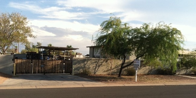


Property Detail
1575 E 18Th Ave
102-07-216B
LOTS 43, 44 AND 45 OF PALM SPRINGS UNIT SIX, BOOK 13 OF MAPS PAGE 48, ALL IN SECTION 28, TOWNSHIP 01 NORTH, RANGE 08 EAST, 24,626. 41 SQUARE FEET, 0.57 ACRES
Industrialgeneral
Pinal
UNDESIGNAT
Arizona
B and X Area of moderate flood hazard, usually the area between the limits of the 100-year and 500-year floods.
43-44
2024
0.56 AC
2025
Superstition Corridor
000315
Phoenix
3,268 SF
Phoenix-Mesa-Chandler, AZ
NEARBY LISTINGS FOR SALE OR LEASE
DEMOGRAPHICS near 1575 E 18Th Ave
1 mile
3 mile
5 mile
2024 Total Population
9,647
46,772
99,849
2029 Population
11,249
54,860
112,671
Pop Growth 2024-2029
+ 16.61%
+ 17.29%
+ 12.84%
Average Age
44
50
49
2024 Total Households
4,024
21,160
43,015
HH Growth 2024-2029
+ 16.40%
+ 17.26%
+ 13.45%
Median Household Inc
$71,884
$58,562
$71,190
Avg Household Size
2.40
2.20
2.30
2024 Avg HH Vehicles
2.00
2.00
2.00
Median Home Value
$340,893
$288,233
$367,414
Median Year Built
1988
1993
1996
Nearby Places
Map Layers
Map Styles
 Street
 Aerial
Transit
 Traffic
 Biking
Places
Listings with unknown addresses are not visible on the map
- Restaurants
- Banks
- Shops
- Fitness
- Groceries
PUBLIC TRANSPORTATION
AIRPORT
Phoenix-Mesa Gateway
Drive
Walk
Distance
Phoenix-Mesa Gateway
26 min
16.6 mi
Phoenix Sky Harbor International
Drive
Walk
Distance
Phoenix Sky Harbor International
42 min
32.0 mi
The World's #1 Commercial Real Estate Marketplace
Connect with us
© 2026 CoStar Group
The information above has been obtained from sources believed reliable. While we do not doubt its accuracy we have not verified it and make no guarantee, warranty or representation about it. It is your responsibility to independently confirm its accuracy and completeness. Any projections, opinions, assumptions, or estimates used are for example only and do not represent the current or future performance of the property. The value of this transaction to you depends on tax and other factors which should be evaluated by your tax, financial, and legal advisors. You and your advisors should conduct a careful, independent investigation of the property to determine to your satisfaction the suitability of the property for your needs.