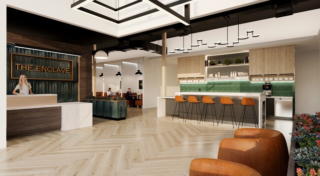
Property Record
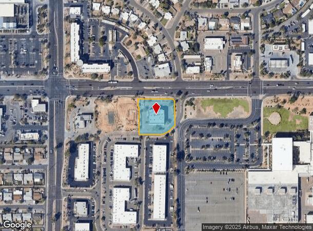
1575 N Hayden Rd, Scottsdale, AZ 85257

Current Lease Availabilities
NEARBY LISTINGS FOR SALE OR LEASE
Property Detail
1575 N Hayden Rd
Phoenix
Commerce Court Commercial Mld
Phoenix-Mesa-Scottsdale, AZ
177124 COMMERCE COURT COMMERCIAL MLD
131-09-002S
Maricopa
Warehouse
Arizona
2025
1
2025
1.15 AC
218300
Scottsdale/Salt River
8,770 SF
DEMOGRAPHICS near 1575 N Hayden Rd
1 Mile
3 Mile
5 Mile
2024 Total Population
16,547
93,498
291,981
2029 Population
17,970
103,197
318,645
Pop Growth 2024-2029
+ 8.60%
+ 10.37%
+ 9.13%
Average Age
41
39
37
2024 Total Households
8,151
46,536
130,832
HH Growth 2024-2029
+ 8.69%
+ 10.61%
+ 9.57%
Median Household Inc
$77,777
$77,931
$66,485
Avg Household Size
1.90
1.90
2.10
2024 Avg HH Vehicles
2.00
2.00
2.00
Median Home Value
$373,042
$426,463
$433,033
Median Year Built
1974
1978
1980
Nearby Places
Map Layers
Map Styles
 Street
 Aerial
- Restaurants
- Banks
- Shops
- Fitness
- Groceries
PUBLIC TRANSPORTATION
AIRPORT
Phoenix Sky Harbor International
DRIVE
WALK
Distance
Phoenix Sky Harbor International
13 min
7.9 mi
Phoenix-Mesa Gateway
DRIVE
WALK
Distance
Phoenix-Mesa Gateway
36 min
24.9 mi
Freight Ports
Port of San Diego
DRIVE
WALK
Distance
Port of San Diego
409 min
364.8 mi
Nearby Properties
Address
Land Use
TOTAL SIZE
Lot Size
Zoning
Address
Land Use
TOTAL SIZE
Lot Size
Zoning
Address
Land Use
TOTAL SIZE
Lot Size
Zoning
4.59 AC
I-1
Address
Land Use
TOTAL SIZE
Lot Size
Zoning
1,870,689 SF
46.77 AC
I-P
Address
Land Use
TOTAL SIZE
Lot Size
Zoning
2,636,740 SF
21.88 AC
C-DT
Address
Land Use
TOTAL SIZE
Lot Size
Zoning
401,544 SF
64.59 AC
GID
Address
Land Use
TOTAL SIZE
Lot Size
Zoning
9,160 SF
2.57 AC
DDMU2
Address
Land Use
TOTAL SIZE
Lot Size
Zoning
3.77 AC
PNC
Address
Land Use
TOTAL SIZE
Lot Size
Zoning
44,971 SF
2.06 AC
C-R
Address
Land Use
TOTAL SIZE
Lot Size
Zoning
58,061 SF
5.43 AC
C-C
Address
Land Use
TOTAL SIZE
Lot Size
Zoning
3,010 SF
35.44 AC
R110
Address
Land Use
TOTAL SIZE
Lot Size
Zoning
8.79 AC
PF
Address
Land Use
TOTAL SIZE
Lot Size
Zoning
197,454 SF
18.97 AC
PF
Address
Land Use
TOTAL SIZE
Lot Size
Zoning
511,014 SF
5.01 AC
I-1
Address
Land Use
TOTAL SIZE
Lot Size
Zoning
307,604 SF
37.83 AC
R-7
Address
Land Use
TOTAL SIZE
Lot Size
Zoning
301,376 SF
8.77 AC
PAD
Address
Land Use
TOTAL SIZE
Lot Size
Zoning
776,898 SF
27.32 AC
C-R
Address
Land Use
TOTAL SIZE
Lot Size
Zoning
544,646 SF
1.65 AC
MU4
Address
Land Use
TOTAL SIZE
Lot Size
Zoning
401,437 SF
17.70 AC
C-R
Address
Land Use
TOTAL SIZE
Lot Size
Zoning
640,230 SF
3.94 AC
MU4
Address
Land Use
TOTAL SIZE
Lot Size
Zoning
1,229,384 SF
4.81 AC
Address
Land Use
TOTAL SIZE
Lot Size
Zoning
469,012 SF
11.39 AC
I-1
Address
Land Use
TOTAL SIZE
Lot Size
Zoning
420,534 SF
1.62 AC
PAD
Address
Land Use
TOTAL SIZE
Lot Size
Zoning
392,172 SF
7.50 AC
DM2
Address
Land Use
TOTAL SIZE
Lot Size
Zoning
268,262 SF
1.15 AC
C-DT
Address
Land Use
TOTAL SIZE
Lot Size
Zoning
564,649 SF
7.19 AC
RCC
The World's #1 Commercial Real Estate Marketplace
Connect with us
© 2025 CoStar Group
The information above has been obtained from sources believed reliable. While we do not doubt its accuracy we have not verified it and make no guarantee, warranty or representation about it. It is your responsibility to independently confirm its accuracy and completeness. Any projections, opinions, assumptions, or estimates used are for example only and do not represent the current or future performance of the property. The value of this transaction to you depends on tax and other factors which should be evaluated by your tax, financial, and legal advisors. You and your advisors should conduct a careful, independent investigation of the property to determine to your satisfaction the suitability of the property for your needs.