Property Record
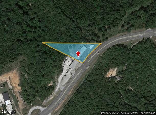
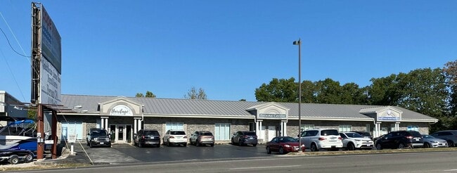
15765 State Highway 13, Reeds Spring, MO 65737

Current Lease Availabilities
NEARBY LISTINGS FOR SALE OR LEASE
-
-
View all Reeds Spring listings for lease on LoopNet.com
Property Detail
15765 State Highway 13
11-7.0-26-000-000-013.000
Glen Oaks
Stripcommercialcenter
NW LYING N OF HWY, EX BEG NWC, TH SE 560 TO R/W, SW 749 TO W LINE NW, N TO POB
X
Stone
29209C0195D
Missouri
2024
1.90 AC
2025
Branson
090605
Other Market Areas
10,831 SF
DEMOGRAPHICS near 15765 State Highway 13
1 Mile
3 Mile
5 Mile
2024 Total Population
278
4,123
12,473
2029 Population
299
4,494
13,767
Pop Growth 2024-2029
+ 7.55%
+ 9.00%
+ 10.37%
Average Age
47
50
51
2024 Total Households
119
1,810
5,533
HH Growth 2024-2029
+ 7.56%
+ 8.34%
+ 9.78%
Median Household Inc
$41,785
$50,594
$57,784
Avg Household Size
2.30
2.20
2.20
2024 Avg HH Vehicles
2.00
2.00
2.00
Median Home Value
$178,333
$206,944
$226,101
Median Year Built
1991
1990
1993
Nearby Places
Map Layers
Map Styles
 Street
 Aerial
- Restaurants
- Banks
- Shops
- Fitness
- Groceries
Nearby Properties
Address
Land Use
TOTAL SIZE
Lot Size
Zoning
Address
Land Use
TOTAL SIZE
Lot Size
Zoning
153,535 SF
18.72 AC
NA
Address
Land Use
TOTAL SIZE
Lot Size
Zoning
20,653 SF
2.89 AC
NA
Address
Land Use
TOTAL SIZE
Lot Size
Zoning
6,000 SF
11.93 AC
NA
Address
Land Use
TOTAL SIZE
Lot Size
Zoning
11,180 SF
7.03 AC
NA
Address
Land Use
TOTAL SIZE
Lot Size
Zoning
4,000 SF
5.06 AC
NA
Address
Land Use
TOTAL SIZE
Lot Size
Zoning
12,104 SF
2.11 AC
NA
Address
Land Use
TOTAL SIZE
Lot Size
Zoning
44,979 SF
12.80 AC
NA
Address
Land Use
TOTAL SIZE
Lot Size
Zoning
7,088 SF
1.98 AC
C-2
Address
Land Use
TOTAL SIZE
Lot Size
Zoning
10,080 SF
2.12 AC
NA
Address
Land Use
TOTAL SIZE
Lot Size
Zoning
14,748 SF
1.60 AC
NA
Address
Land Use
TOTAL SIZE
Lot Size
Zoning
77,252 SF
36.08 AC
A-1
Address
Land Use
TOTAL SIZE
Lot Size
Zoning
23,640 SF
29.64 AC
NA
Address
Land Use
TOTAL SIZE
Lot Size
Zoning
92,520 SF
Address
Land Use
TOTAL SIZE
Lot Size
Zoning
5,168 SF
3.14 AC
NA
Address
Land Use
TOTAL SIZE
Lot Size
Zoning
8,997 SF
2.50 AC
NA
Address
Land Use
TOTAL SIZE
Lot Size
Zoning
6,114 SF
4 AC
NA
Address
Land Use
TOTAL SIZE
Lot Size
Zoning
25,052 SF
3.98 AC
NA
Address
Land Use
TOTAL SIZE
Lot Size
Zoning
6,360 SF
1.13 AC
NA
Address
Land Use
TOTAL SIZE
Lot Size
Zoning
11,860 SF
5.40 AC
C-2
Address
Land Use
TOTAL SIZE
Lot Size
Zoning
36,558 SF
7.60 AC
NA
Address
Land Use
TOTAL SIZE
Lot Size
Zoning
8,915 SF
3.27 AC
C-2
Address
Land Use
TOTAL SIZE
Lot Size
Zoning
6,000 SF
0.87 AC
Address
Land Use
TOTAL SIZE
Lot Size
Zoning
46,225 SF
Address
Land Use
TOTAL SIZE
Lot Size
Zoning
3,520 SF
1.30 AC
Address
Land Use
TOTAL SIZE
Lot Size
Zoning
21,150 SF
3.41 AC
NA
Address
Land Use
TOTAL SIZE
Lot Size
Zoning
30,924 SF
3.20 AC
NA
Address
Land Use
TOTAL SIZE
Lot Size
Zoning
2,384 SF
12.50 AC
NA
Address
Land Use
TOTAL SIZE
Lot Size
Zoning
30,783 SF
19 AC
C-2
The World's #1 Commercial Real Estate Marketplace
Connect with us
© 2026 CoStar Group
The information above has been obtained from sources believed reliable. While we do not doubt its accuracy we have not verified it and make no guarantee, warranty or representation about it. It is your responsibility to independently confirm its accuracy and completeness. Any projections, opinions, assumptions, or estimates used are for example only and do not represent the current or future performance of the property. The value of this transaction to you depends on tax and other factors which should be evaluated by your tax, financial, and legal advisors. You and your advisors should conduct a careful, independent investigation of the property to determine to your satisfaction the suitability of the property for your needs.