Property Record
1577 S Getty St, Muskegon, MI 49442
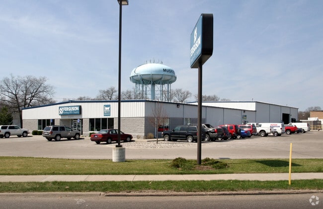
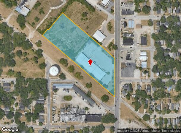
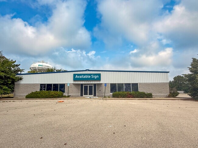
This Property Is For Sale
NEARBY LISTINGS FOR SALE OR LEASE
Property Detail
1577 S Getty St
24-205-098-0001-40
City Of Muskegon Revised Plat (Of 1903)
Commercialnec
CITY OF MUSKEGON REVISED PLAT OF 1903 COM AT SW COR BLK 98 TH N 50D 19M 42S W 914.16 FT ALG C&O RR R/W TH N 37D 55M 00S E 81.
X
Muskegon
26121C0276E
Michigan
2024
5.24 AC
2025
Muskegon Heights
000300
West Michigan
27,900 SF
Muskegon, MI
DEMOGRAPHICS near 1577 S Getty St
1 Mile
3 Mile
5 Mile
2024 Total Population
17,034
59,189
105,360
2029 Population
17,221
59,981
106,068
Pop Growth 2024-2029
+ 1.10%
+ 1.34%
+ 0.67%
Average Age
37
38
40
2024 Total Households
4,826
22,705
41,457
HH Growth 2024-2029
+ 1.08%
+ 1.34%
+ 0.65%
Median Household Inc
$36,354
$38,132
$49,585
Avg Household Size
2.60
2.30
2.40
2024 Avg HH Vehicles
1.00
1.00
2.00
Median Home Value
$59,990
$85,977
$136,534
Median Year Built
1947
1954
1960
Nearby Places
Map Layers
Map Styles
 Street
 Aerial
- Restaurants
- Banks
- Shops
- Fitness
- Groceries
Nearby Properties
Address
Land Use
TOTAL SIZE
Lot Size
Zoning
Address
Land Use
TOTAL SIZE
Lot Size
Zoning
490,693 SF
22.70 AC
Address
Land Use
TOTAL SIZE
Lot Size
Zoning
82,643 SF
5.20 AC
MC
Address
Land Use
TOTAL SIZE
Lot Size
Zoning
129,264 SF
R
Address
Land Use
TOTAL SIZE
Lot Size
Zoning
84,452 SF
6.82 AC
PUD
Address
Land Use
TOTAL SIZE
Lot Size
Zoning
446,688 SF
29.50 AC
RM-2
Address
Land Use
TOTAL SIZE
Lot Size
Zoning
892,516 SF
57.88 AC
I
Address
Land Use
TOTAL SIZE
Lot Size
Zoning
223,802 SF
22.02 AC
SC-1
Address
Land Use
TOTAL SIZE
Lot Size
Zoning
79,321 SF
4.28 AC
B-3
Address
Land Use
TOTAL SIZE
Lot Size
Zoning
184,130 SF
3.16 AC
FBC-MS
Address
Land Use
TOTAL SIZE
Lot Size
Zoning
271,435 SF
13.80 AC
I-2
Address
Land Use
TOTAL SIZE
Lot Size
Zoning
116,657 SF
1.60 AC
FBC-UR
Address
Land Use
TOTAL SIZE
Lot Size
Zoning
219,341 SF
18.55 AC
C-SE
Address
Land Use
TOTAL SIZE
Lot Size
Zoning
79,321 SF
5 AC
FBC-MS
Address
Land Use
TOTAL SIZE
Lot Size
Zoning
80,572 SF
12.98 AC
I-1
Address
Land Use
TOTAL SIZE
Lot Size
Zoning
194,708 SF
15.59 AC
C-2
Address
Land Use
TOTAL SIZE
Lot Size
Zoning
142,000 SF
1.60 AC
FBC-DT
Address
Land Use
TOTAL SIZE
Lot Size
Zoning
19,171 SF
6.55 AC
MC
Address
Land Use
TOTAL SIZE
Lot Size
Zoning
71,329 SF
I-2
Address
Land Use
TOTAL SIZE
Lot Size
Zoning
2,044 SF
4.10 AC
RT
Address
Land Use
TOTAL SIZE
Lot Size
Zoning
82,895 SF
13.09 AC
SC-1
Address
Land Use
TOTAL SIZE
Lot Size
Zoning
85,577 SF
8.72 AC
PUD
Address
Land Use
TOTAL SIZE
Lot Size
Zoning
163,658 SF
14.70 AC
RM-1
Address
Land Use
TOTAL SIZE
Lot Size
Zoning
33,750 SF
R
Address
Land Use
TOTAL SIZE
Lot Size
Zoning
241,589 SF
14.60 AC
I-2
Address
Land Use
TOTAL SIZE
Lot Size
Zoning
180,144 SF
3.29 AC
RM-1
Address
Land Use
TOTAL SIZE
Lot Size
Zoning
121,466 SF
11.65 AC
SC-1
Address
Land Use
TOTAL SIZE
Lot Size
Zoning
143,193 SF
13.82 AC
SC-1
Address
Land Use
TOTAL SIZE
Lot Size
Zoning
122.75 AC
R-2
Address
Land Use
TOTAL SIZE
Lot Size
Zoning
124,416 SF
7.41 AC
MFR
Address
Land Use
TOTAL SIZE
Lot Size
Zoning
60,658 SF
4.42 AC
RM-2
The World's #1 Commercial Real Estate Marketplace
Connect with us
© 2026 CoStar Group
The information above has been obtained from sources believed reliable. While we do not doubt its accuracy we have not verified it and make no guarantee, warranty or representation about it. It is your responsibility to independently confirm its accuracy and completeness. Any projections, opinions, assumptions, or estimates used are for example only and do not represent the current or future performance of the property. The value of this transaction to you depends on tax and other factors which should be evaluated by your tax, financial, and legal advisors. You and your advisors should conduct a careful, independent investigation of the property to determine to your satisfaction the suitability of the property for your needs.