Property Record
158 E Shore Rd, Halesite, NY 11743
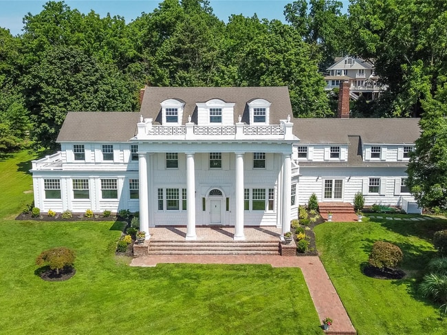
This Property Is For Sale
NEARBY LISTINGS FOR SALE OR LEASE
Property Detail
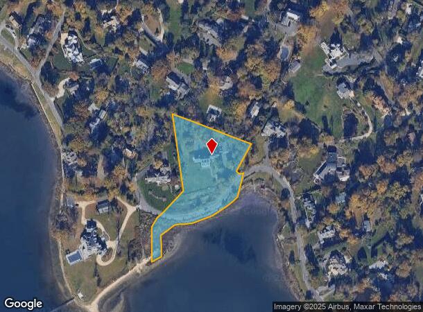
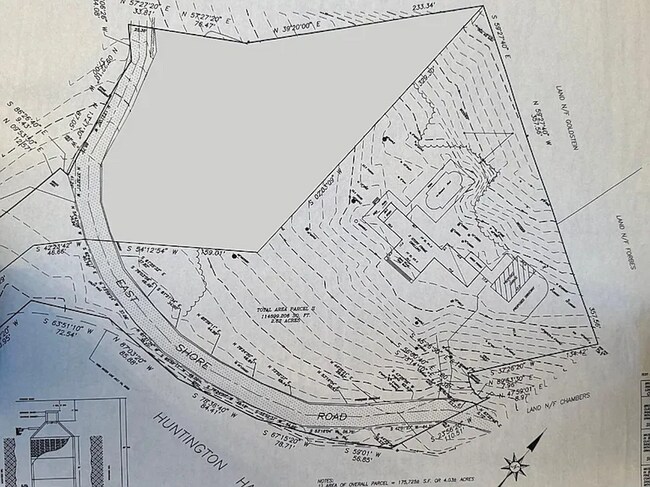
158 E Shore Rd
Long Island (New York)
Map Of The Murphy Sub
Nassau County-Suffolk County, NY
Suffolk
0402-002-00-03-00-012-002
New York
Sfr
2.60 AC
VE
Western Suffolk
36103C0318H
DEMOGRAPHICS near 158 E Shore Rd
1 Mile
3 Mile
5 Mile
2024 Total Population
3,342
34,285
99,513
2029 Population
3,343
34,134
98,247
Pop Growth 2024-2029
+ 0.03%
(0.44%)
(1.27%)
Average Age
48
45
42
2024 Total Households
1,339
13,029
34,193
HH Growth 2024-2029
(0.22%)
(0.78%)
(1.48%)
Median Household Inc
$174,814
$169,531
$154,931
Avg Household Size
2.50
2.60
2.80
2024 Avg HH Vehicles
2.00
2.00
2.00
Median Home Value
$895,331
$827,514
$773,630
Median Year Built
1954
1956
1958
Nearby Places
Map Layers
Map Styles
 Street
 Aerial
- Restaurants
- Banks
- Shops
- Fitness
- Groceries
PUBLIC TRANSPORTATION
COMMUTER RAIL
Huntington Station (Port Jefferson Branch - Long Island Rail Road)
DRIVE
WALK
Distance
Huntington Station (Port Jefferson Branch - Long Island Rail Road)
10 min
3.9 mi
Greenlawn Station (Port Jefferson Branch - Long Island Rail Road)
DRIVE
WALK
Distance
Greenlawn Station (Port Jefferson Branch - Long Island Rail Road)
13 min
5.7 mi
AIRPORT
Long Island MacArthur
DRIVE
WALK
Distance
Long Island MacArthur
40 min
22.0 mi
LaGuardia
DRIVE
WALK
Distance
LaGuardia
52 min
31.4 mi
Freight Ports
NY - Red Hook Container Terminal
DRIVE
WALK
Distance
NY - Red Hook Container Terminal
63 min
39.5 mi
Nearby Properties
Address
Land Use
TOTAL SIZE
Lot Size
Zoning
Address
Land Use
TOTAL SIZE
Lot Size
Zoning
42.21 AC
CA
Address
Land Use
TOTAL SIZE
Lot Size
Zoning
2,764 SF
0.24 AC
HC
Address
Land Use
TOTAL SIZE
Lot Size
Zoning
1,413.30 AC
R80
Address
Land Use
TOTAL SIZE
Lot Size
Zoning
1.50 AC
R40
Address
Land Use
TOTAL SIZE
Lot Size
Zoning
11.85 AC
RMS
Address
Land Use
TOTAL SIZE
Lot Size
Zoning
2.60 AC
R80
Address
Land Use
TOTAL SIZE
Lot Size
Zoning
225 AC
R80
Address
Land Use
TOTAL SIZE
Lot Size
Zoning
0.51 AC
R40
Address
Land Use
TOTAL SIZE
Lot Size
Zoning
2,214 SF
0.57 AC
R20
Address
Land Use
TOTAL SIZE
Lot Size
Zoning
36 AC
R20
Address
Land Use
TOTAL SIZE
Lot Size
Zoning
Address
Land Use
TOTAL SIZE
Lot Size
Zoning
Address
Land Use
TOTAL SIZE
Lot Size
Zoning
3,264 SF
0.42 AC
R15
Address
Land Use
TOTAL SIZE
Lot Size
Zoning
43.30 AC
R40
Address
Land Use
TOTAL SIZE
Lot Size
Zoning
Address
Land Use
TOTAL SIZE
Lot Size
Zoning
16.23 AC
Address
Land Use
TOTAL SIZE
Lot Size
Zoning
1.17 AC
BUS3
Address
Land Use
TOTAL SIZE
Lot Size
Zoning
71.90 AC
R80
Address
Land Use
TOTAL SIZE
Lot Size
Zoning
106.50 AC
R80
Address
Land Use
TOTAL SIZE
Lot Size
Zoning
0.92 AC
R20
Address
Land Use
TOTAL SIZE
Lot Size
Zoning
2.16 AC
CR200
Address
Land Use
TOTAL SIZE
Lot Size
Zoning
2.07 AC
CR200
Address
Land Use
TOTAL SIZE
Lot Size
Zoning
1.94 AC
CR200
Address
Land Use
TOTAL SIZE
Lot Size
Zoning
78 AC
R80
Address
Land Use
TOTAL SIZE
Lot Size
Zoning
9.60 AC
R10
Address
Land Use
TOTAL SIZE
Lot Size
Zoning
7.10 AC
R80
Address
Land Use
TOTAL SIZE
Lot Size
Zoning
8 AC
R80
Address
Land Use
TOTAL SIZE
Lot Size
Zoning
13.80 AC
R40
Address
Land Use
TOTAL SIZE
Lot Size
Zoning
9.90 AC
R7
Address
Land Use
TOTAL SIZE
Lot Size
Zoning
10.80 AC
The World's #1 Commercial Real Estate Marketplace
Connect with us
© 2026 CoStar Group
The information above has been obtained from sources believed reliable. While we do not doubt its accuracy we have not verified it and make no guarantee, warranty or representation about it. It is your responsibility to independently confirm its accuracy and completeness. Any projections, opinions, assumptions, or estimates used are for example only and do not represent the current or future performance of the property. The value of this transaction to you depends on tax and other factors which should be evaluated by your tax, financial, and legal advisors. You and your advisors should conduct a careful, independent investigation of the property to determine to your satisfaction the suitability of the property for your needs.