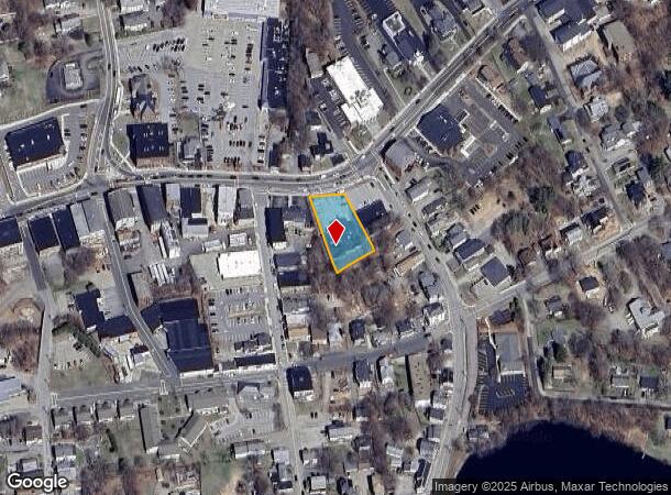
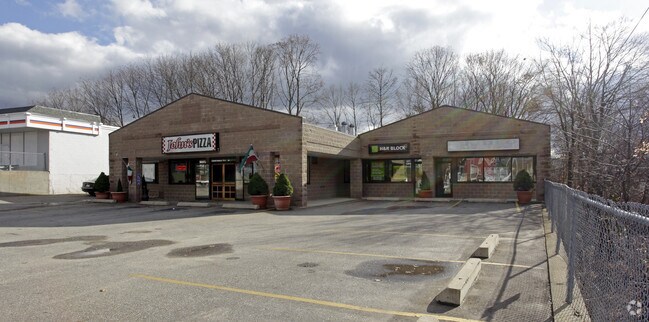
Property Record
158 Main St, Spencer, MA 01562

NEARBY LISTINGS FOR SALE OR LEASE
Property Detail
158 Main St
Departmentstore
Worcester
X
Massachusetts
25027C0780F
0.45 AC
2025
Outlying Worcester
2025
Boston
726200
Worcester, MA
6,200 SF
SPEN-000007U-000063
DEMOGRAPHICS near 158 Main St
1 Mile
3 Mile
5 Mile
2024 Total Population
6,085
11,891
25,354
2029 Population
6,035
11,851
25,273
Pop Growth 2024-2029
(0.82%)
(0.34%)
(0.32%)
Average Age
43
43
43
2024 Total Households
2,825
5,077
10,275
HH Growth 2024-2029
(0.92%)
(0.43%)
(0.40%)
Median Household Inc
$53,703
$72,839
$82,818
Avg Household Size
2.10
2.30
2.40
2024 Avg HH Vehicles
1.00
2.00
2.00
Median Home Value
$286,803
$338,248
$350,486
Median Year Built
1953
1968
1971
Nearby Places
Map Layers
Map Styles
 Street
 Aerial
- Restaurants
- Banks
- Shops
- Fitness
- Groceries
PUBLIC TRANSPORTATION
AIRPORT
Worcester Regional
DRIVE
WALK
Distance
Worcester Regional
23 min
10.4 mi
Freight Ports
Port of Boston
DRIVE
WALK
Distance
Port of Boston
82 min
57.2 mi
SALE & LEASE HISTORY
LISTING DATE
SALE/LEASE

Oct 17, 2016
For Lease
Nearby Properties
Address
Land Use
TOTAL SIZE
Lot Size
Zoning
Address
Land Use
TOTAL SIZE
Lot Size
Zoning
78,309 SF
33.51 AC
Address
Land Use
TOTAL SIZE
Lot Size
Zoning
1,408 SF
42.06 AC
HB1
Address
Land Use
TOTAL SIZE
Lot Size
Zoning
141,180 SF
29.33 AC
Address
Land Use
TOTAL SIZE
Lot Size
Zoning
78,145 SF
20.75 AC
Address
Land Use
TOTAL SIZE
Lot Size
Zoning
206,992 SF
55.33 AC
HB1
Address
Land Use
TOTAL SIZE
Lot Size
Zoning
68,052 SF
44 AC
Address
Land Use
TOTAL SIZE
Lot Size
Zoning
3,576 SF
13 AC
Address
Land Use
TOTAL SIZE
Lot Size
Zoning
31,680 SF
6 AC
C
Address
Land Use
TOTAL SIZE
Lot Size
Zoning
81,001 SF
11 AC
Address
Land Use
TOTAL SIZE
Lot Size
Zoning
9.40 AC
HB1
Address
Land Use
TOTAL SIZE
Lot Size
Zoning
25,000 SF
22.13 AC
C
Address
Land Use
TOTAL SIZE
Lot Size
Zoning
39,660 SF
1.28 AC
Address
Land Use
TOTAL SIZE
Lot Size
Zoning
59,508 SF
1.84 AC
Address
Land Use
TOTAL SIZE
Lot Size
Zoning
1,092 SF
35.26 AC
Address
Land Use
TOTAL SIZE
Lot Size
Zoning
6.86 AC
HB1
Address
Land Use
TOTAL SIZE
Lot Size
Zoning
44,769 SF
22.40 AC
Address
Land Use
TOTAL SIZE
Lot Size
Zoning
14,690 SF
5.47 AC
Address
Land Use
TOTAL SIZE
Lot Size
Zoning
127.62 AC
R
Address
Land Use
TOTAL SIZE
Lot Size
Zoning
4,070 SF
7.59 AC
Address
Land Use
TOTAL SIZE
Lot Size
Zoning
5,128 SF
43.47 AC
Address
Land Use
TOTAL SIZE
Lot Size
Zoning
6,656 SF
2.26 AC
Address
Land Use
TOTAL SIZE
Lot Size
Zoning
20,255 SF
4.23 AC
Address
Land Use
TOTAL SIZE
Lot Size
Zoning
4,285 SF
0.98 AC
Address
Land Use
TOTAL SIZE
Lot Size
Zoning
53,197 SF
12.78 AC
Address
Land Use
TOTAL SIZE
Lot Size
Zoning
18,628 SF
1.17 AC
Address
Land Use
TOTAL SIZE
Lot Size
Zoning
Address
Land Use
TOTAL SIZE
Lot Size
Zoning
21.71 AC
Address
Land Use
TOTAL SIZE
Lot Size
Zoning
12,969 SF
1.47 AC
Address
Land Use
TOTAL SIZE
Lot Size
Zoning
59,279 SF
3.63 AC
Address
Land Use
TOTAL SIZE
Lot Size
Zoning
50,000 SF
53.70 AC
The World's #1 Commercial Real Estate Marketplace
Connect with us
© 2026 CoStar Group
The information above has been obtained from sources believed reliable. While we do not doubt its accuracy we have not verified it and make no guarantee, warranty or representation about it. It is your responsibility to independently confirm its accuracy and completeness. Any projections, opinions, assumptions, or estimates used are for example only and do not represent the current or future performance of the property. The value of this transaction to you depends on tax and other factors which should be evaluated by your tax, financial, and legal advisors. You and your advisors should conduct a careful, independent investigation of the property to determine to your satisfaction the suitability of the property for your needs.