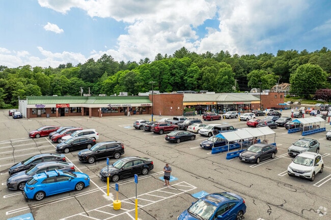
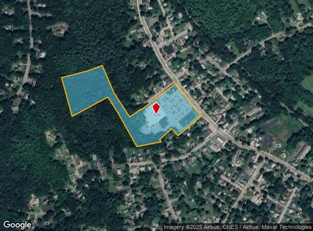
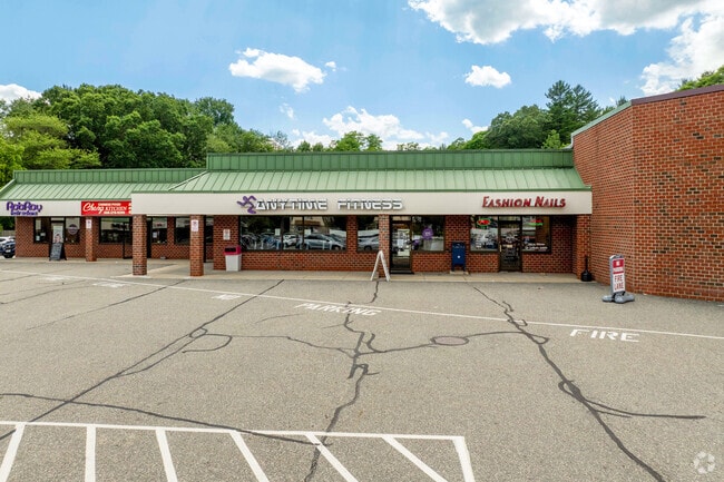
Property Record
158 N Main St, Uxbridge, MA 01569
NEARBY LISTINGS FOR SALE OR LEASE
Property Detail
158 N Main St
UXBR-000018C-002831
Uxbridge
Commercialnec
Worcester
X
Massachusetts
25027C1009E
12.90 AC
2025
Outlying Worcester
2025
Boston
749200
Worcester, MA-CT
75,977 SF
DEMOGRAPHICS near 158 N Main St
1 Mile
3 Mile
5 Mile
2024 Total Population
5,365
19,457
41,231
2029 Population
5,312
19,459
41,136
Pop Growth 2024-2029
(0.99%)
+ 0.01%
(0.23%)
Average Age
43
43
42
2024 Total Households
2,252
7,701
15,751
HH Growth 2024-2029
(1.11%)
(0.09%)
(0.30%)
Median Household Inc
$113,163
$106,354
$113,615
Avg Household Size
2.40
2.50
2.60
2024 Avg HH Vehicles
2.00
2.00
2.00
Median Home Value
$386,666
$409,663
$417,088
Median Year Built
1957
1975
1980
Nearby Places
Map Layers
Map Styles
 Street
 Aerial
- Restaurants
- Banks
- Shops
- Fitness
- Groceries
PUBLIC TRANSPORTATION
AIRPORT
Worcester Regional
DRIVE
WALK
Distance
Worcester Regional
39 min
21.5 mi
Rhode Island Tf Green International
DRIVE
WALK
Distance
Rhode Island Tf Green International
48 min
31.6 mi
Freight Ports
Port of Davisville, RI
DRIVE
WALK
Distance
Port of Davisville, RI
61 min
43.5 mi
SALE & LEASE HISTORY
LISTING DATE
SALE/LEASE

Sep 25, 2016
For Lease
Mar 21, 2018
For Lease
Nearby Properties
Address
Land Use
TOTAL SIZE
Lot Size
Zoning
Address
Land Use
TOTAL SIZE
Lot Size
Zoning
450,800 SF
56.41 AC
I
Address
Land Use
TOTAL SIZE
Lot Size
Zoning
158,722 SF
77.55 AC
Address
Land Use
TOTAL SIZE
Lot Size
Zoning
173,667 SF
2.44 AC
Address
Land Use
TOTAL SIZE
Lot Size
Zoning
246,552 SF
24.55 AC
Address
Land Use
TOTAL SIZE
Lot Size
Zoning
108.65 AC
RC
Address
Land Use
TOTAL SIZE
Lot Size
Zoning
192,817 SF
36.30 AC
RA
Address
Land Use
TOTAL SIZE
Lot Size
Zoning
50.49 AC
Address
Land Use
TOTAL SIZE
Lot Size
Zoning
37,781 SF
29.16 AC
Address
Land Use
TOTAL SIZE
Lot Size
Zoning
55,671 SF
3.53 AC
Address
Land Use
TOTAL SIZE
Lot Size
Zoning
67,716 SF
42.39 AC
Address
Land Use
TOTAL SIZE
Lot Size
Zoning
119,200 SF
16.15 AC
I
Address
Land Use
TOTAL SIZE
Lot Size
Zoning
93,424 SF
6.90 AC
I
Address
Land Use
TOTAL SIZE
Lot Size
Zoning
19,913 SF
0.78 AC
Address
Land Use
TOTAL SIZE
Lot Size
Zoning
41,071 SF
0.61 AC
RA
Address
Land Use
TOTAL SIZE
Lot Size
Zoning
25,601 SF
9.26 AC
RB
Address
Land Use
TOTAL SIZE
Lot Size
Zoning
2.72 AC
Address
Land Use
TOTAL SIZE
Lot Size
Zoning
57,554 SF
2.19 AC
Address
Land Use
TOTAL SIZE
Lot Size
Zoning
28,170 SF
2.02 AC
RC
Address
Land Use
TOTAL SIZE
Lot Size
Zoning
28,875 SF
0.61 AC
Address
Land Use
TOTAL SIZE
Lot Size
Zoning
45,960 SF
2.88 AC
RA
Address
Land Use
TOTAL SIZE
Lot Size
Zoning
44,668 SF
3.84 AC
Address
Land Use
TOTAL SIZE
Lot Size
Zoning
52,700 SF
3.98 AC
Address
Land Use
TOTAL SIZE
Lot Size
Zoning
35,706 SF
2.87 AC
RB
Address
Land Use
TOTAL SIZE
Lot Size
Zoning
37,580 SF
14.10 AC
RB
Address
Land Use
TOTAL SIZE
Lot Size
Zoning
54.40 AC
Address
Land Use
TOTAL SIZE
Lot Size
Zoning
70,000 SF
5.84 AC
I
Address
Land Use
TOTAL SIZE
Lot Size
Zoning
15,258 SF
0.69 AC
Address
Land Use
TOTAL SIZE
Lot Size
Zoning
1.04 AC
Address
Land Use
TOTAL SIZE
Lot Size
Zoning
8.56 AC
The World's #1 Commercial Real Estate Marketplace
Connect with us
© 2025 CoStar Group
The information above has been obtained from sources believed reliable. While we do not doubt its accuracy we have not verified it and make no guarantee, warranty or representation about it. It is your responsibility to independently confirm its accuracy and completeness. Any projections, opinions, assumptions, or estimates used are for example only and do not represent the current or future performance of the property. The value of this transaction to you depends on tax and other factors which should be evaluated by your tax, financial, and legal advisors. You and your advisors should conduct a careful, independent investigation of the property to determine to your satisfaction the suitability of the property for your needs.