Property Record
1580 Gallup Rd, Chapel Hill, NC 27517

NEARBY LISTINGS FOR SALE OR LEASE
-
-
View all Chapel Hill listings for sale on LoopNet.com
Property Detail
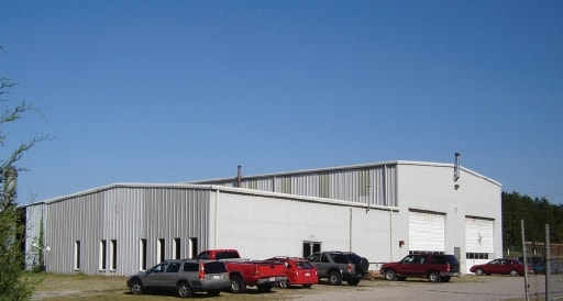
1580 Gallup Rd
64618
South East Gulf
Policefirecivildefense
9.99 ACRES AC 9.99 BK 6 PG 40
X
Chatham
3710961500K
North Carolina
2025
9.99 AC
2025
Chatham County
012201
Raleigh/Durham
9,000 SF
Durham-Chapel Hill, NC
DEMOGRAPHICS near 1580 Gallup Rd
1 Mile
3 Mile
5 Mile
2024 Total Population
119
777
4,289
2029 Population
130
846
4,694
Pop Growth 2024-2029
+ 9.24%
+ 8.88%
+ 9.44%
Average Age
45
44
44
2024 Total Households
55
338
1,753
HH Growth 2024-2029
+ 9.09%
+ 9.17%
+ 9.58%
Median Household Inc
$39,317
$55,848
$74,496
Avg Household Size
2.10
2.30
2.40
2024 Avg HH Vehicles
2.00
3.00
3.00
Median Home Value
$102,381
$136,363
$181,226
Median Year Built
1989
1988
1989
Nearby Places
Map Layers
Map Styles
 Street
 Aerial
- Restaurants
- Banks
- Shops
- Fitness
- Groceries
PUBLIC TRANSPORTATION
AIRPORT
Raleigh-Durham International
DRIVE
WALK
Distance
Raleigh-Durham International
59 min
47.6 mi
Nearby Properties
Address
Land Use
TOTAL SIZE
Lot Size
Zoning
Address
Land Use
TOTAL SIZE
Lot Size
Zoning
142,593 SF
416.63 AC
HEAVY INDU
Address
Land Use
TOTAL SIZE
Lot Size
Zoning
648.71 AC
RESIDENTIA
Address
Land Use
TOTAL SIZE
Lot Size
Zoning
305,591 SF
115.49 AC
IND-H
Address
Land Use
TOTAL SIZE
Lot Size
Zoning
220.11 AC
R-1
Address
Land Use
TOTAL SIZE
Lot Size
Zoning
450.03 AC
RESIDENTIA
Address
Land Use
TOTAL SIZE
Lot Size
Zoning
41.77 AC
CZ
Address
Land Use
TOTAL SIZE
Lot Size
Zoning
38,100 SF
25.56 AC
IL
Address
Land Use
TOTAL SIZE
Lot Size
Zoning
422.32 AC
RESIDENTIA
Address
Land Use
TOTAL SIZE
Lot Size
Zoning
292.46 AC
RESIDENTIA
Address
Land Use
TOTAL SIZE
Lot Size
Zoning
4,245 SF
45 AC
R-1
Address
Land Use
TOTAL SIZE
Lot Size
Zoning
254.68 AC
RESIDENTIA
Address
Land Use
TOTAL SIZE
Lot Size
Zoning
254.48 AC
R-5
Address
Land Use
TOTAL SIZE
Lot Size
Zoning
1,004 SF
205.64 AC
RESIDENTIA
Address
Land Use
TOTAL SIZE
Lot Size
Zoning
14,400 SF
14.55 AC
IND-H
Address
Land Use
TOTAL SIZE
Lot Size
Zoning
210 AC
IND-H
Address
Land Use
TOTAL SIZE
Lot Size
Zoning
83.13 AC
HEAVY INDU
Address
Land Use
TOTAL SIZE
Lot Size
Zoning
51.97 AC
RESIDENTIA
Address
Land Use
TOTAL SIZE
Lot Size
Zoning
20.15 AC
HEAVY INDU
Address
Land Use
TOTAL SIZE
Lot Size
Zoning
172.27 AC
IND-H
Address
Land Use
TOTAL SIZE
Lot Size
Zoning
4,630 SF
2.80 AC
R-1
Address
Land Use
TOTAL SIZE
Lot Size
Zoning
2,241 SF
52.05 AC
RESIDENTIA
Address
Land Use
TOTAL SIZE
Lot Size
Zoning
18.90 AC
HEAVY INDU
Address
Land Use
TOTAL SIZE
Lot Size
Zoning
6,000 SF
2.35 AC
RESIDENTIA
Address
Land Use
TOTAL SIZE
Lot Size
Zoning
6,239 SF
4.65 AC
RESIDENTIA
Address
Land Use
TOTAL SIZE
Lot Size
Zoning
170.47 AC
RESIDENTIA
Address
Land Use
TOTAL SIZE
Lot Size
Zoning
1,768 SF
40.41 AC
RESIDENTIA
Address
Land Use
TOTAL SIZE
Lot Size
Zoning
125.73 AC
RESIDENTIA
Address
Land Use
TOTAL SIZE
Lot Size
Zoning
2,332 SF
2.90 AC
R-1
Address
Land Use
TOTAL SIZE
Lot Size
Zoning
1,136 SF
77.18 AC
RESIDENTIA
The World's #1 Commercial Real Estate Marketplace
Connect with us
© 2025 CoStar Group
The information above has been obtained from sources believed reliable. While we do not doubt its accuracy we have not verified it and make no guarantee, warranty or representation about it. It is your responsibility to independently confirm its accuracy and completeness. Any projections, opinions, assumptions, or estimates used are for example only and do not represent the current or future performance of the property. The value of this transaction to you depends on tax and other factors which should be evaluated by your tax, financial, and legal advisors. You and your advisors should conduct a careful, independent investigation of the property to determine to your satisfaction the suitability of the property for your needs.