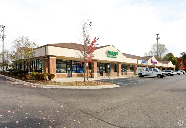
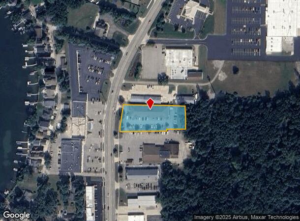
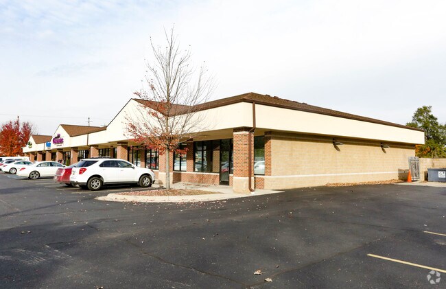
Property Record
1580 N Leroy St, Fenton, MI 48430
NEARBY LISTINGS FOR SALE OR LEASE
Property Detail
1580 N Leroy St
Flint, MI
Dauner Sub
53-24-551-020
N 25 FT OF LOT 25 DAUNER SUB & A PARCEL OF LAND BEG AT NW COR OF LOT 25 DAUNER SUB TH E 276.63 FT TH S 25 FT TH E 110 FT TH N
Commercialnec
Genesee
X
Michigan
26049C0429D
25
2024
1.11 AC
2025
Flint
013202
Detroit
13,950 SF
DEMOGRAPHICS near 1580 N Leroy St
1 Mile
3 Mile
5 Mile
2024 Total Population
4,407
22,341
48,232
2029 Population
4,359
21,985
47,753
Pop Growth 2024-2029
(1.09%)
(1.59%)
(0.99%)
Average Age
42
42
42
2024 Total Households
2,010
9,494
19,437
HH Growth 2024-2029
(1.04%)
(1.63%)
(1.08%)
Median Household Inc
$66,031
$82,977
$84,295
Avg Household Size
2.20
2.30
2.40
2024 Avg HH Vehicles
2.00
2.00
2.00
Median Home Value
$242,581
$268,327
$258,120
Median Year Built
1984
1984
1986
Nearby Places
Map Layers
Map Styles
 Street
 Aerial
- Restaurants
- Banks
- Shops
- Fitness
- Groceries
PUBLIC TRANSPORTATION
AIRPORT
Bishop International
DRIVE
WALK
Distance
Bishop International
29 min
14.1 mi
SALE & LEASE HISTORY
LISTING DATE
SALE/LEASE

Sep 25, 2016
For Lease
Oct 04, 2017
For Lease
Nearby Properties
Address
Land Use
TOTAL SIZE
Lot Size
Zoning
Address
Land Use
TOTAL SIZE
Lot Size
Zoning
572,804 SF
39.61 AC
SEVERAL
Address
Land Use
TOTAL SIZE
Lot Size
Zoning
30,286 SF
3.29 AC
SEVERAL
Address
Land Use
TOTAL SIZE
Lot Size
Zoning
215,494 SF
25.02 AC
GBD
Address
Land Use
TOTAL SIZE
Lot Size
Zoning
70,522 SF
23.58 AC
SEVERAL
Address
Land Use
TOTAL SIZE
Lot Size
Zoning
167,681 SF
20.39 AC
HDR
Address
Land Use
TOTAL SIZE
Lot Size
Zoning
82,447 SF
8.96 AC
GBD
Address
Land Use
TOTAL SIZE
Lot Size
Zoning
148,951 SF
10.02 AC
HDR
Address
Land Use
TOTAL SIZE
Lot Size
Zoning
176,132 SF
27.71 AC
R-M
Address
Land Use
TOTAL SIZE
Lot Size
Zoning
114,408 SF
13.53 AC
GBD
Address
Land Use
TOTAL SIZE
Lot Size
Zoning
87,925 SF
13.49 AC
GBD
Address
Land Use
TOTAL SIZE
Lot Size
Zoning
87,847 SF
12.71 AC
GBD
Address
Land Use
TOTAL SIZE
Lot Size
Zoning
126,064 SF
10.80 AC
GBD
Address
Land Use
TOTAL SIZE
Lot Size
Zoning
13,220 SF
7.90 AC
GBD
Address
Land Use
TOTAL SIZE
Lot Size
Zoning
97,830 SF
12.16 AC
GBD
Address
Land Use
TOTAL SIZE
Lot Size
Zoning
145,076 SF
11.95 AC
HDR
Address
Land Use
TOTAL SIZE
Lot Size
Zoning
112,330 SF
11.82 AC
IND
Address
Land Use
TOTAL SIZE
Lot Size
Zoning
89,158 SF
7.87 AC
C-3
Address
Land Use
TOTAL SIZE
Lot Size
Zoning
46,732 SF
10.50 AC
SEVERAL
Address
Land Use
TOTAL SIZE
Lot Size
Zoning
41,427 SF
0.41 AC
CBD
Address
Land Use
TOTAL SIZE
Lot Size
Zoning
72,624 SF
8.18 AC
MHR
Address
Land Use
TOTAL SIZE
Lot Size
Zoning
44,343 SF
3.94 AC
NO DATA TO
Address
Land Use
TOTAL SIZE
Lot Size
Zoning
48,096 SF
6.39 AC
GBD
Address
Land Use
TOTAL SIZE
Lot Size
Zoning
30,000 SF
0.66 AC
HDR
Address
Land Use
TOTAL SIZE
Lot Size
Zoning
26,719 SF
4.07 AC
GBD
Address
Land Use
TOTAL SIZE
Lot Size
Zoning
103,896 SF
7.30 AC
IND
Address
Land Use
TOTAL SIZE
Lot Size
Zoning
73,243 SF
7.55 AC
NO DATA TO
Address
Land Use
TOTAL SIZE
Lot Size
Zoning
94,597 SF
9.10 AC
NO DATA TO
Address
Land Use
TOTAL SIZE
Lot Size
Zoning
92,600 SF
13.34 AC
Address
Land Use
TOTAL SIZE
Lot Size
Zoning
47,372 SF
7.12 AC
GBD
Address
Land Use
TOTAL SIZE
Lot Size
Zoning
20,969 SF
3.67 AC
LDR
The World's #1 Commercial Real Estate Marketplace
Connect with us
© 2026 CoStar Group
The information above has been obtained from sources believed reliable. While we do not doubt its accuracy we have not verified it and make no guarantee, warranty or representation about it. It is your responsibility to independently confirm its accuracy and completeness. Any projections, opinions, assumptions, or estimates used are for example only and do not represent the current or future performance of the property. The value of this transaction to you depends on tax and other factors which should be evaluated by your tax, financial, and legal advisors. You and your advisors should conduct a careful, independent investigation of the property to determine to your satisfaction the suitability of the property for your needs.