Property Record
1580 Wallace Ave, San Francisco, CA 94124
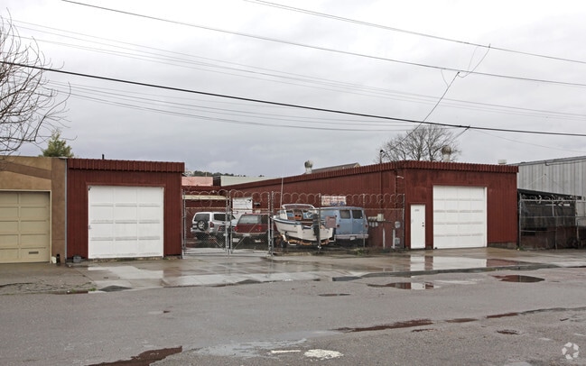

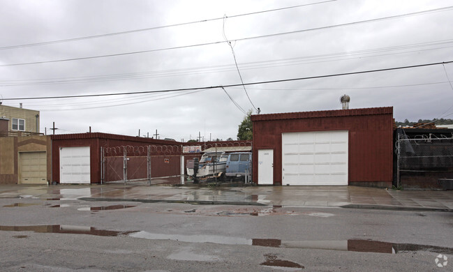
This Property Is For Sale
NEARBY LISTINGS FOR SALE OR LEASE
Property Detail
1580 Wallace Ave
San Francisco-San Mateo-Redwood City, CA
BLK 435 PART OF LOT 10
4829-008
San Francisco
Industrialgeneral
California
2024
8
2025
0.17 AC
023200
Bayview/Hunters Point
3,750 SF
San Francisco
DEMOGRAPHICS near 1580 Wallace Ave
1 mile
3 mile
5 mile
2024 Total Population
37,594
217,610
639,215
2029 Population
33,891
199,773
591,366
Pop Growth 2024-2029
(9.85%)
(8.20%)
(7.49%)
Average Age
41
42
42
2024 Total Households
10,803
76,061
262,790
HH Growth 2024-2029
(10.49%)
(8.49%)
(7.83%)
Median Household Inc
$66,157
$128,462
$119,912
Avg Household Size
3.10
2.70
2.30
2024 Avg HH Vehicles
2.00
1.00
1.00
Median Home Value
$950,579
$1,075,736
$1,080,769
Median Year Built
1963
1949
1953
Nearby Places
Map Layers
Map Styles
 Street
 Aerial
Transit
 Traffic
 Biking
Places
Listings with unknown addresses are not visible on the map
- Restaurants
- Banks
- Shops
- Fitness
- Groceries
PUBLIC TRANSPORTATION
TRANSIT/SUBWAY
Williams Station Outbound (T Third Street - San Francisco Municipal Railway (MUNI Metro))
Drive
Walk
Distance
Williams Station Outbound (T Third Street - San Francisco Municipal Railway (MUNI Metro))
1 min
4 min
0.2 mi
Carroll Station Outbound (T Third Street - San Francisco Municipal Railway (MUNI Metro))
Drive
Walk
Distance
Carroll Station Outbound (T Third Street - San Francisco Municipal Railway (MUNI Metro))
2 min
7 min
0.4 mi
Revere Ave & 3rd St (T Third Street - San Francisco Municipal Railway (MUNI Metro))
Drive
Walk
Distance
Revere Ave & 3rd St (T Third Street - San Francisco Municipal Railway (MUNI Metro))
2 min
9 min
0.4 mi
Gilman/Paul Station Inbound (T Third Street - San Francisco Municipal Railway (MUNI Metro))
Drive
Walk
Distance
Gilman/Paul Station Inbound (T Third Street - San Francisco Municipal Railway (MUNI Metro))
2 min
10 min
0.5 mi
Oakdale/Palou Station (T Third Street - San Francisco Municipal Railway (MUNI Metro))
Drive
Walk
Distance
Oakdale/Palou Station (T Third Street - San Francisco Municipal Railway (MUNI Metro))
3 min
12 min
0.6 mi
COMMUTER RAIL
Drive
Walk
Distance
5 min
1.7 mi
Drive
Walk
Distance
10 min
3.4 mi
AIRPORT
San Francisco International
Drive
Walk
Distance
San Francisco International
17 min
9.6 mi
Metro Oakland International
Drive
Walk
Distance
Metro Oakland International
37 min
23.2 mi
Norman Y Mineta San Jose International
Drive
Walk
Distance
Norman Y Mineta San Jose International
52 min
41.2 mi
Freight Ports
Port of San Francisco
Drive
Walk
Distance
Port of San Francisco
15 min
6.6 mi
Nearby Properties
Address
Land Use
TOTAL SIZE
Lot Size
Zoning
Address
Land Use
TOTAL SIZE
Lot Size
Zoning
750,370 SF
3.25 AC
MBR3
Address
Land Use
TOTAL SIZE
Lot Size
Zoning
248,303 SF
4.35 AC
Address
Land Use
TOTAL SIZE
Lot Size
Zoning
10.92 AC
Address
Land Use
TOTAL SIZE
Lot Size
Zoning
2.74 AC
Address
Land Use
TOTAL SIZE
Lot Size
Zoning
314,826 SF
1.85 AC
MB-RA
Address
Land Use
TOTAL SIZE
Lot Size
Zoning
10.92 AC
Address
Land Use
TOTAL SIZE
Lot Size
Zoning
241,659 SF
3.76 AC
Address
Land Use
TOTAL SIZE
Lot Size
Zoning
230,853 SF
3.76 AC
Address
Land Use
TOTAL SIZE
Lot Size
Zoning
302,084 SF
0.88 AC
MBO
Address
Land Use
TOTAL SIZE
Lot Size
Zoning
222,000 SF
1 AC
MB-RA
Address
Land Use
TOTAL SIZE
Lot Size
Zoning
10.92 AC
Address
Land Use
TOTAL SIZE
Lot Size
Zoning
250,884 SF
1.66 AC
MB-RA
Address
Land Use
TOTAL SIZE
Lot Size
Zoning
248,974 SF
0.88 AC
MBO
Address
Land Use
TOTAL SIZE
Lot Size
Zoning
2.22 AC
M1
Address
Land Use
TOTAL SIZE
Lot Size
Zoning
333,244 SF
2.67 AC
UMU
Address
Land Use
TOTAL SIZE
Lot Size
Zoning
347,857 SF
2.76 AC
Address
Land Use
TOTAL SIZE
Lot Size
Zoning
346,710 SF
7.45 AC
RH2
Address
Land Use
TOTAL SIZE
Lot Size
Zoning
167,053 SF
0.99 AC
MB-RA
Address
Land Use
TOTAL SIZE
Lot Size
Zoning
3.49 AC
Address
Land Use
TOTAL SIZE
Lot Size
Zoning
100,732 SF
4.55 AC
M2
Address
Land Use
TOTAL SIZE
Lot Size
Zoning
210,036 SF
23.85 AC
UMU
Address
Land Use
TOTAL SIZE
Lot Size
Zoning
243,176 SF
1.48 AC
UMU
Address
Land Use
TOTAL SIZE
Lot Size
Zoning
164,464 SF
1.05 AC
MB-RA
Address
Land Use
TOTAL SIZE
Lot Size
Zoning
319,279 SF
1.85 AC
MB-RA
Address
Land Use
TOTAL SIZE
Lot Size
Zoning
231,687 SF
8.64 AC
Address
Land Use
TOTAL SIZE
Lot Size
Zoning
54,000 SF
1.67 AC
PDR2
Address
Land Use
TOTAL SIZE
Lot Size
Zoning
199,678 SF
1.06 AC
UMU
Address
Land Use
TOTAL SIZE
Lot Size
Zoning
157,256 SF
1.15 AC
M2
Address
Land Use
TOTAL SIZE
Lot Size
Zoning
439,294 SF
5.43 AC
PDR2
Address
Land Use
TOTAL SIZE
Lot Size
Zoning
147,000 SF
1.84 AC
UMU
The World's #1 Commercial Real Estate Marketplace
Connect with us
© 2026 CoStar Group
The information above has been obtained from sources believed reliable. While we do not doubt its accuracy we have not verified it and make no guarantee, warranty or representation about it. It is your responsibility to independently confirm its accuracy and completeness. Any projections, opinions, assumptions, or estimates used are for example only and do not represent the current or future performance of the property. The value of this transaction to you depends on tax and other factors which should be evaluated by your tax, financial, and legal advisors. You and your advisors should conduct a careful, independent investigation of the property to determine to your satisfaction the suitability of the property for your needs.