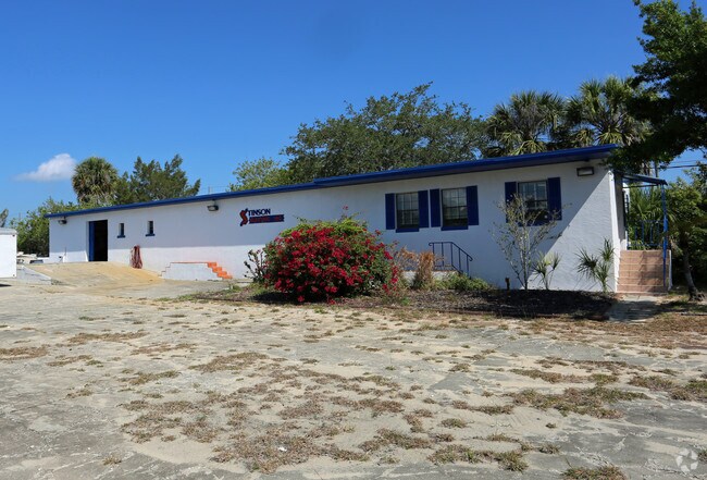
Property Record
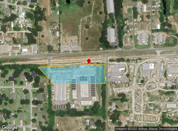
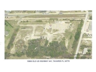
15800 Old Us Highway 441, Tavares, FL 32778
NEARBY LISTINGS FOR SALE OR LEASE
-
-
-
No Photo
-
View all Tavares listings for sale on LoopNet.com
Property Detail
15800 Old Us Highway 441
Orlando-Kissimmee-Sanford, FL
Fairview Sub
34-19-26-0150-000-00200
FAIRVIEW SUB OF GOV LOTS 1 12 PB 5 PG 14 LOT 2 BEGIN AT THE NORTHWEST CORNER OF LOT 2 RUN WEST 150 FEET BEGIN AGAIN AT THE POINT OF BEGINNING RUN SOUTH TO THE SOUTHWEST CORNER OF LOT 2 NORTHWESTERLY TO INTERSECT FIRST LINE AND THE NORTH 1/2 OF LOT 3
Shipyard
Lake
X
Florida
12069C0362E
2
2024
8.24 AC
2026
Lake County
030807
Orlando
1,980 SF
DEMOGRAPHICS near 15800 Old Us Highway 441
1 Mile
3 Mile
5 Mile
2024 Total Population
5,502
32,022
72,506
2029 Population
6,448
37,479
84,623
Pop Growth 2024-2029
+ 17.19%
+ 17.04%
+ 16.71%
Average Age
45
46
45
2024 Total Households
2,420
14,050
31,098
HH Growth 2024-2029
+ 17.07%
+ 16.98%
+ 16.65%
Median Household Inc
$42,816
$51,249
$56,900
Avg Household Size
2.20
2.20
2.30
2024 Avg HH Vehicles
2.00
2.00
2.00
Median Home Value
$229,053
$228,039
$238,911
Median Year Built
1990
1983
1984
Nearby Places
Map Layers
Map Styles
 Street
 Aerial
- Restaurants
- Banks
- Shops
- Fitness
- Groceries
PUBLIC TRANSPORTATION
AIRPORT
Orlando Sanford International
DRIVE
WALK
Distance
Orlando Sanford International
54 min
35.6 mi
Freight Ports
Port Canaveral
DRIVE
WALK
Distance
Port Canaveral
111 min
90.1 mi
Nearby Properties
Address
Land Use
TOTAL SIZE
Lot Size
Zoning
Address
Land Use
TOTAL SIZE
Lot Size
Zoning
730,215 SF
151.42 AC
PD
Address
Land Use
TOTAL SIZE
Lot Size
Zoning
15,600 SF
9.32 AC
PFD
Address
Land Use
TOTAL SIZE
Lot Size
Zoning
330,732 SF
35.24 AC
Address
Land Use
TOTAL SIZE
Lot Size
Zoning
302,511 SF
23.16 AC
Address
Land Use
TOTAL SIZE
Lot Size
Zoning
278,266 SF
23.85 AC
PD
Address
Land Use
TOTAL SIZE
Lot Size
Zoning
226,508 SF
19.15 AC
Address
Land Use
TOTAL SIZE
Lot Size
Zoning
481,096 SF
2.17 AC
PFD
Address
Land Use
TOTAL SIZE
Lot Size
Zoning
158,442 SF
17.50 AC
MCI
Address
Land Use
TOTAL SIZE
Lot Size
Zoning
267,107 SF
20.40 AC
R1
Address
Land Use
TOTAL SIZE
Lot Size
Zoning
121,005 SF
6.56 AC
Address
Land Use
TOTAL SIZE
Lot Size
Zoning
85,539 SF
9.39 AC
Address
Land Use
TOTAL SIZE
Lot Size
Zoning
97,053 SF
1.50 AC
PFD
Address
Land Use
TOTAL SIZE
Lot Size
Zoning
45,732 SF
5.68 AC
PD
Address
Land Use
TOTAL SIZE
Lot Size
Zoning
204,433 SF
28.43 AC
R1
Address
Land Use
TOTAL SIZE
Lot Size
Zoning
135,298 SF
9.22 AC
SR
Address
Land Use
TOTAL SIZE
Lot Size
Zoning
190,551 SF
20.31 AC
GC
Address
Land Use
TOTAL SIZE
Lot Size
Zoning
29,066 SF
0.76 AC
Address
Land Use
TOTAL SIZE
Lot Size
Zoning
36,261 SF
6.27 AC
PD
Address
Land Use
TOTAL SIZE
Lot Size
Zoning
71,076 SF
1.42 AC
Address
Land Use
TOTAL SIZE
Lot Size
Zoning
79,296 SF
8.54 AC
R3
Address
Land Use
TOTAL SIZE
Lot Size
Zoning
129,512 SF
15 AC
Address
Land Use
TOTAL SIZE
Lot Size
Zoning
2,000 SF
3.04 AC
PFD
Address
Land Use
TOTAL SIZE
Lot Size
Zoning
45,310 SF
2.93 AC
PFD
Address
Land Use
TOTAL SIZE
Lot Size
Zoning
94,435 SF
8.16 AC
GC
Address
Land Use
TOTAL SIZE
Lot Size
Zoning
146,690 SF
15.19 AC
RMF2
Address
Land Use
TOTAL SIZE
Lot Size
Zoning
50,754 SF
17.31 AC
R1
Address
Land Use
TOTAL SIZE
Lot Size
Zoning
106,175 SF
8.10 AC
UR
Address
Land Use
TOTAL SIZE
Lot Size
Zoning
54,035 SF
1.65 AC
PD
Address
Land Use
TOTAL SIZE
Lot Size
Zoning
87,462 SF
4.94 AC
RMF3
Address
Land Use
TOTAL SIZE
Lot Size
Zoning
2,000 SF
2.14 AC
PFD
The World's #1 Commercial Real Estate Marketplace
Connect with us
© 2025 CoStar Group
The information above has been obtained from sources believed reliable. While we do not doubt its accuracy we have not verified it and make no guarantee, warranty or representation about it. It is your responsibility to independently confirm its accuracy and completeness. Any projections, opinions, assumptions, or estimates used are for example only and do not represent the current or future performance of the property. The value of this transaction to you depends on tax and other factors which should be evaluated by your tax, financial, and legal advisors. You and your advisors should conduct a careful, independent investigation of the property to determine to your satisfaction the suitability of the property for your needs.