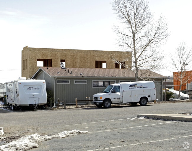
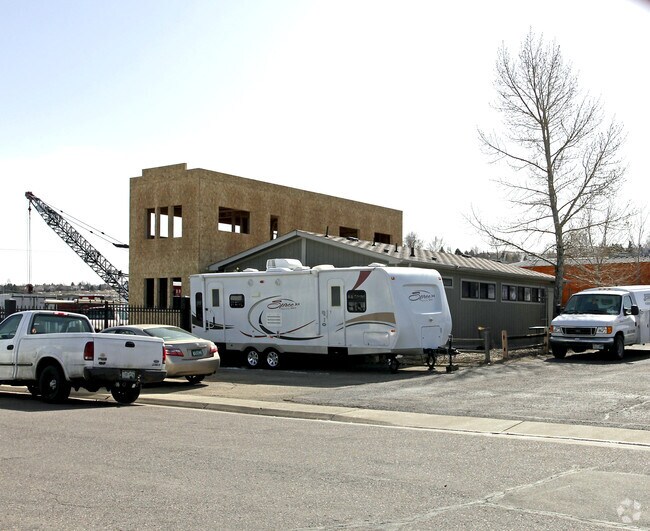
Property Record
15800 W 5Th Ave, Golden, CO 80401

Save to a Folder
{{folder.Name}}
{{folder.ListingIds.length}} Properties
{{folder.ListingIds.length}} Property
Create a New Folder
Property Detail
15800 W 5Th Ave
Denver-Aurora-Centennial, CO
SECTION 12 TOWNSHIP 04 RANGE 70 SUBDIVISIONCD 249600 SUBDIVISIONNAME FOOTHILL INDUSTRIES BLOCK LOT 0004 SIZE: 17190 TRACT 00B VALUE: .395
40-122-01-012
JEFFERSON
Industrialgeneral
Colorado
B and X Area of moderate flood hazard, usually the area between the limits of the 100-year and 500-year floods.
4
2025
0.40 AC
2025
West Denver
011720
Denver
4,126 SF
NEARBY LISTINGS FOR SALE OR LEASE
DEMOGRAPHICS near 15800 W 5Th Ave
1 mile
3 mile
5 mile
2025 Total Population
6,717
52,578
137,020
2030 Population
6,697
52,491
136,777
Pop Growth 2025-2030
(0.30%)
(0.17%)
(0.18%)
Average Age
42
40
42
2025 Total Households
2,791
22,484
57,006
HH Growth 2025-2030
(0.43%)
(0.19%)
(0.20%)
Median Household Inc
$110,000
$93,688
$98,791
Avg Household Size
2.40
2.20
2.30
2025 Avg HH Vehicles
2.00
2.00
2.00
Median Home Value
$650,987
$670,905
$723,820
Median Year Built
1979
1977
1976
Nearby Places
Map Layers
Map Styles
 Street
 Aerial
Layers
 Traffic
 Biking
Places
Listings with unknown addresses are not visible on the map
- Restaurants
- Banks
- Shops
- Fitness
- Groceries
PUBLIC TRANSPORTATION
COMMUTER RAIL
Wheat Ridge - Ward Station Track 1 (Union Station to Wheat Ridge Ward Station - Regional Transportation District)
Drive
Walk
Distance
Wheat Ridge - Ward Station Track 1 (Union Station to Wheat Ridge Ward Station - Regional Transportation District)
14 min
7.6 mi
Arvada Ridge Station Track 1 (Union Station to Wheat Ridge Ward Station - Regional Transportation District)
Drive
Walk
Distance
Arvada Ridge Station Track 1 (Union Station to Wheat Ridge Ward Station - Regional Transportation District)
14 min
8.6 mi
AIRPORT
Denver International
Drive
Walk
Distance
Denver International
47 min
36.1 mi
Freight Ports
Tulsa Port Of Catoosa
Drive
Walk
Distance
Tulsa Port Of Catoosa
744 min
721.6 mi
Nearby Properties
Address
Land Use
TOTAL SIZE
Lot Size
Zoning
Address
Land Use
TOTAL SIZE
Lot Size
Zoning
943,179 SF
23.96 AC
Address
Land Use
TOTAL SIZE
Lot Size
Zoning
Address
Land Use
TOTAL SIZE
Lot Size
Zoning
82,133 SF
6.07 AC
Address
Land Use
TOTAL SIZE
Lot Size
Zoning
3,195,026 SF
562.97 AC
Address
Land Use
TOTAL SIZE
Lot Size
Zoning
367,452 SF
38.94 AC
Address
Land Use
TOTAL SIZE
Lot Size
Zoning
94,560 SF
6.03 AC
Address
Land Use
TOTAL SIZE
Lot Size
Zoning
1,193,158 SF
68.86 AC
Address
Land Use
TOTAL SIZE
Lot Size
Zoning
420,482 SF
66.03 AC
Address
Land Use
TOTAL SIZE
Lot Size
Zoning
25,925 SF
7.12 AC
Address
Land Use
TOTAL SIZE
Lot Size
Zoning
103,076 SF
1.28 AC
Address
Land Use
TOTAL SIZE
Lot Size
Zoning
352,259 SF
17.94 AC
Address
Land Use
TOTAL SIZE
Lot Size
Zoning
117,036 SF
1.38 AC
Address
Land Use
TOTAL SIZE
Lot Size
Zoning
90,776 SF
5 AC
Address
Land Use
TOTAL SIZE
Lot Size
Zoning
52,103 SF
2.44 AC
Address
Land Use
TOTAL SIZE
Lot Size
Zoning
Address
Land Use
TOTAL SIZE
Lot Size
Zoning
135,113 SF
2.58 AC
Address
Land Use
TOTAL SIZE
Lot Size
Zoning
198,081 SF
Address
Land Use
TOTAL SIZE
Lot Size
Zoning
322,105 SF
136.23 AC
Address
Land Use
TOTAL SIZE
Lot Size
Zoning
104,088 SF
1.31 AC
Address
Land Use
TOTAL SIZE
Lot Size
Zoning
162,271 SF
8.20 AC
Address
Land Use
TOTAL SIZE
Lot Size
Zoning
282,190 SF
6.42 AC
PD
Address
Land Use
TOTAL SIZE
Lot Size
Zoning
229,819 SF
29.97 AC
Address
Land Use
TOTAL SIZE
Lot Size
Zoning
188,554 SF
33.28 AC
Address
Land Use
TOTAL SIZE
Lot Size
Zoning
484,918 SF
58.36 AC
Address
Land Use
TOTAL SIZE
Lot Size
Zoning
39,374 SF
1.20 AC
Address
Land Use
TOTAL SIZE
Lot Size
Zoning
198,147 SF
2.55 AC
Address
Land Use
TOTAL SIZE
Lot Size
Zoning
118,522 SF
7.07 AC
PD
Address
Land Use
TOTAL SIZE
Lot Size
Zoning
239,510 SF
6.63 AC
Address
Land Use
TOTAL SIZE
Lot Size
Zoning
55,030 SF
4.94 AC
Address
Land Use
TOTAL SIZE
Lot Size
Zoning
40,616 SF
3.34 AC
The World's #1 Commercial Real Estate Marketplace
Connect with us
© 2026 CoStar Group
The information above has been obtained from sources believed reliable. While we do not doubt its accuracy we have not verified it and make no guarantee, warranty or representation about it. It is your responsibility to independently confirm its accuracy and completeness. Any projections, opinions, assumptions, or estimates used are for example only and do not represent the current or future performance of the property. The value of this transaction to you depends on tax and other factors which should be evaluated by your tax, financial, and legal advisors. You and your advisors should conduct a careful, independent investigation of the property to determine to your satisfaction the suitability of the property for your needs.