Property Record
1581 1 Ave S, Hawley, MN 56549
NEARBY LISTINGS FOR SALE OR LEASE
-
-
View all Hawley listings for sale on LoopNet.com
Property Detail
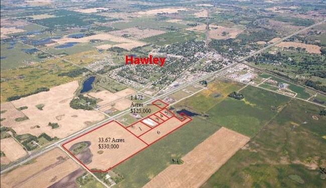
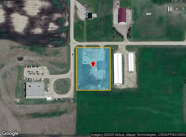
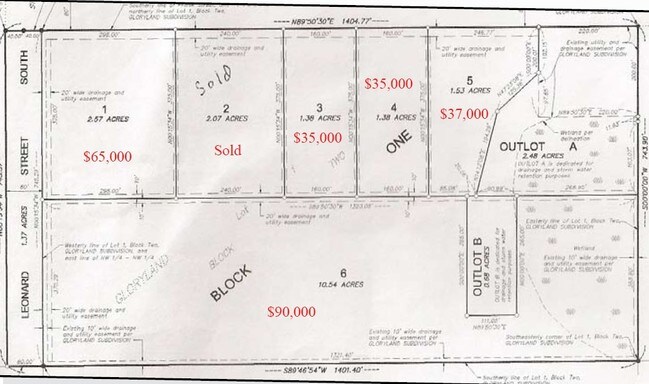
1581 1 Ave S
Fargo, ND-MN
Gloryland 2Nd Sub
13-056-0010
SUBDIVISIONNAME GLORYLAND 2ND SUB LOT 001 BLOCK 001 SUBDIVISIONCD 13056
Commercialnec
Clay
X
Minnesota
27027C0414E
1
2025
2.57 AC
2025
Fargo
030201
Other Market Areas
DEMOGRAPHICS near 1581 1 Ave S
1 Mile
3 Mile
5 Mile
2024 Total Population
1,006
2,349
3,188
2029 Population
975
2,288
3,128
Pop Growth 2024-2029
(3.08%)
(2.60%)
(1.88%)
Average Age
38
39
39
2024 Total Households
396
903
1,199
HH Growth 2024-2029
(3.03%)
(2.55%)
(1.92%)
Median Household Inc
$84,434
$86,869
$90,047
Avg Household Size
2.50
2.60
2.60
2024 Avg HH Vehicles
2.00
2.00
2.00
Median Home Value
$278,813
$288,027
$301,562
Median Year Built
1973
1974
1974
Nearby Places
Map Layers
Map Styles
 Street
 Aerial
- Restaurants
- Banks
- Shops
- Fitness
- Groceries
PUBLIC TRANSPORTATION
AIRPORT
Hector International
DRIVE
WALK
Distance
Hector International
38 min
25.5 mi
Freight Ports
Port Milwaukee
DRIVE
WALK
Distance
Port Milwaukee
631 min
570.7 mi
Nearby Properties
Address
Land Use
TOTAL SIZE
Lot Size
Zoning
Address
Land Use
TOTAL SIZE
Lot Size
Zoning
6.55 AC
Address
Land Use
TOTAL SIZE
Lot Size
Zoning
8.63 AC
Address
Land Use
TOTAL SIZE
Lot Size
Zoning
14.62 AC
Address
Land Use
TOTAL SIZE
Lot Size
Zoning
43.23 AC
Address
Land Use
TOTAL SIZE
Lot Size
Zoning
4.01 AC
Address
Land Use
TOTAL SIZE
Lot Size
Zoning
0.34 AC
Address
Land Use
TOTAL SIZE
Lot Size
Zoning
1.20 AC
Address
Land Use
TOTAL SIZE
Lot Size
Zoning
1.36 AC
Address
Land Use
TOTAL SIZE
Lot Size
Zoning
0.17 AC
Address
Land Use
TOTAL SIZE
Lot Size
Zoning
4.48 AC
Address
Land Use
TOTAL SIZE
Lot Size
Zoning
28.67 AC
Address
Land Use
TOTAL SIZE
Lot Size
Zoning
4.89 AC
Address
Land Use
TOTAL SIZE
Lot Size
Zoning
42.45 AC
Address
Land Use
TOTAL SIZE
Lot Size
Zoning
129.79 AC
Address
Land Use
TOTAL SIZE
Lot Size
Zoning
1.07 AC
Address
Land Use
TOTAL SIZE
Lot Size
Zoning
3.80 AC
Address
Land Use
TOTAL SIZE
Lot Size
Zoning
1.95 AC
Address
Land Use
TOTAL SIZE
Lot Size
Zoning
2.92 AC
Address
Land Use
TOTAL SIZE
Lot Size
Zoning
257.95 AC
Address
Land Use
TOTAL SIZE
Lot Size
Zoning
335.22 AC
Address
Land Use
TOTAL SIZE
Lot Size
Zoning
73.35 AC
Address
Land Use
TOTAL SIZE
Lot Size
Zoning
147.31 AC
Address
Land Use
TOTAL SIZE
Lot Size
Zoning
Address
Land Use
TOTAL SIZE
Lot Size
Zoning
268.60 AC
Address
Land Use
TOTAL SIZE
Lot Size
Zoning
159.80 AC
Address
Land Use
TOTAL SIZE
Lot Size
Zoning
0.36 AC
Address
Land Use
TOTAL SIZE
Lot Size
Zoning
225.47 AC
Address
Land Use
TOTAL SIZE
Lot Size
Zoning
150.66 AC
Address
Land Use
TOTAL SIZE
Lot Size
Zoning
129.30 AC
Address
Land Use
TOTAL SIZE
Lot Size
Zoning
176.52 AC
The World's #1 Commercial Real Estate Marketplace
Connect with us
© 2025 CoStar Group
The information above has been obtained from sources believed reliable. While we do not doubt its accuracy we have not verified it and make no guarantee, warranty or representation about it. It is your responsibility to independently confirm its accuracy and completeness. Any projections, opinions, assumptions, or estimates used are for example only and do not represent the current or future performance of the property. The value of this transaction to you depends on tax and other factors which should be evaluated by your tax, financial, and legal advisors. You and your advisors should conduct a careful, independent investigation of the property to determine to your satisfaction the suitability of the property for your needs.