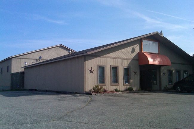
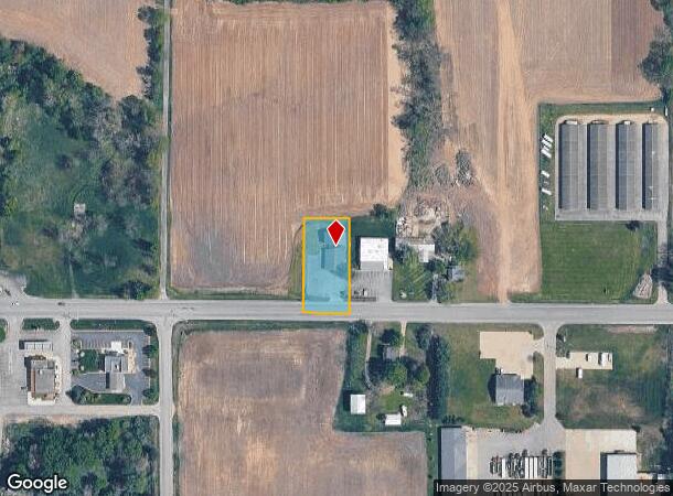
Property Record
1581 142Nd Ave, Dorr, MI 49323
NEARBY LISTINGS FOR SALE OR LEASE
-
-
View all Dorr listings for sale on LoopNet.com
Property Detail
1581 142Nd Ave
05-014-013-10
COM 350' E OF SW COR OF SEC TH E 130' TH N 228' TH W 130' TH S 228' TO POB SEC 14 T4N R12W TAX MAP: 0.68 AC (94)
Gymhealthspa
Allegan
X
Michigan
26005C0255G
0.69 AC
2024
Outlying Allegan County
2025
West Michigan
030403
Holland, MI
4,540 SF
DEMOGRAPHICS near 1581 142Nd Ave
1 Mile
3 Mile
5 Mile
2024 Total Population
2,024
8,067
17,069
2029 Population
2,019
8,036
17,084
Pop Growth 2024-2029
(0.25%)
(0.38%)
+ 0.09%
Average Age
38
37
38
2024 Total Households
699
2,738
5,958
HH Growth 2024-2029
(0.29%)
(0.47%)
+ 0.03%
Median Household Inc
$74,939
$82,473
$77,947
Avg Household Size
2.80
2.90
2.80
2024 Avg HH Vehicles
2.00
2.00
2.00
Median Home Value
$218,111
$230,389
$227,324
Median Year Built
1976
1984
1984
Nearby Places
Map Layers
Map Styles
 Street
 Aerial
- Restaurants
- Banks
- Shops
- Fitness
- Groceries
PUBLIC TRANSPORTATION
AIRPORT
Gerald R Ford International
DRIVE
WALK
Distance
Gerald R Ford International
29 min
20.1 mi
Kalamazoo/Battle Creek International
DRIVE
WALK
Distance
Kalamazoo/Battle Creek International
52 min
41.6 mi
Nearby Properties
Address
Land Use
TOTAL SIZE
Lot Size
Zoning
Address
Land Use
TOTAL SIZE
Lot Size
Zoning
119.76 AC
Address
Land Use
TOTAL SIZE
Lot Size
Zoning
132,905 SF
58.60 AC
Address
Land Use
TOTAL SIZE
Lot Size
Zoning
54,240 SF
36.50 AC
Address
Land Use
TOTAL SIZE
Lot Size
Zoning
196,250 SF
24.59 AC
Address
Land Use
TOTAL SIZE
Lot Size
Zoning
2,351 SF
139 AC
AGRICUL
Address
Land Use
TOTAL SIZE
Lot Size
Zoning
31,890 SF
14 AC
Address
Land Use
TOTAL SIZE
Lot Size
Zoning
32,825 SF
5.05 AC
Address
Land Use
TOTAL SIZE
Lot Size
Zoning
52,071 SF
9.60 AC
Address
Land Use
TOTAL SIZE
Lot Size
Zoning
46,060 SF
11.88 AC
Address
Land Use
TOTAL SIZE
Lot Size
Zoning
197.92 AC
Address
Land Use
TOTAL SIZE
Lot Size
Zoning
12,000 SF
6.47 AC
Address
Land Use
TOTAL SIZE
Lot Size
Zoning
7,200 SF
77.64 AC
I INDUS
Address
Land Use
TOTAL SIZE
Lot Size
Zoning
33,164 SF
6.88 AC
Address
Land Use
TOTAL SIZE
Lot Size
Zoning
640 SF
38.25 AC
Address
Land Use
TOTAL SIZE
Lot Size
Zoning
12,320 SF
4.96 AC
Address
Land Use
TOTAL SIZE
Lot Size
Zoning
16,160 SF
5.48 AC
Address
Land Use
TOTAL SIZE
Lot Size
Zoning
30,600 SF
Address
Land Use
TOTAL SIZE
Lot Size
Zoning
27,540 SF
8.59 AC
Address
Land Use
TOTAL SIZE
Lot Size
Zoning
60.34 AC
Address
Land Use
TOTAL SIZE
Lot Size
Zoning
29,280 SF
5.11 AC
Address
Land Use
TOTAL SIZE
Lot Size
Zoning
120 AC
Address
Land Use
TOTAL SIZE
Lot Size
Zoning
124.93 AC
Address
Land Use
TOTAL SIZE
Lot Size
Zoning
48.34 AC
Address
Land Use
TOTAL SIZE
Lot Size
Zoning
19,800 SF
40.83 AC
Address
Land Use
TOTAL SIZE
Lot Size
Zoning
20,530 SF
2.87 AC
Address
Land Use
TOTAL SIZE
Lot Size
Zoning
1,200 SF
44.70 AC
Address
Land Use
TOTAL SIZE
Lot Size
Zoning
1,901 SF
130 AC
AGRICUL
Address
Land Use
TOTAL SIZE
Lot Size
Zoning
1,538 SF
120 AC
AGRICUL
Address
Land Use
TOTAL SIZE
Lot Size
Zoning
129 AC
Address
Land Use
TOTAL SIZE
Lot Size
Zoning
1,356 SF
60.87 AC
AG
The World's #1 Commercial Real Estate Marketplace
Connect with us
© 2026 CoStar Group
The information above has been obtained from sources believed reliable. While we do not doubt its accuracy we have not verified it and make no guarantee, warranty or representation about it. It is your responsibility to independently confirm its accuracy and completeness. Any projections, opinions, assumptions, or estimates used are for example only and do not represent the current or future performance of the property. The value of this transaction to you depends on tax and other factors which should be evaluated by your tax, financial, and legal advisors. You and your advisors should conduct a careful, independent investigation of the property to determine to your satisfaction the suitability of the property for your needs.