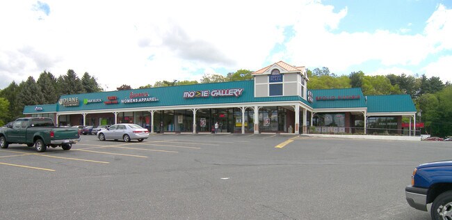
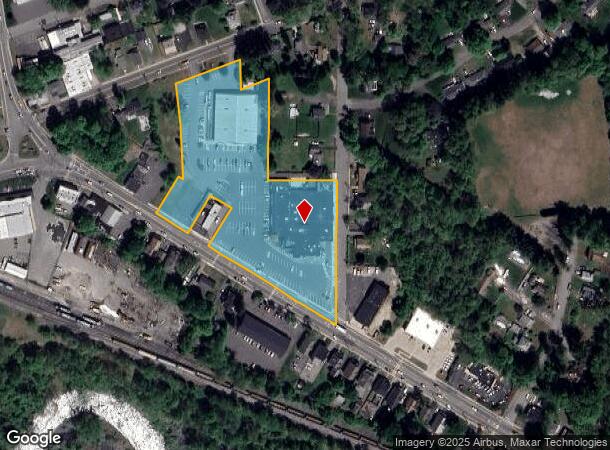
Property Record
1581 N Main St, Palmer, MA 01069
NEARBY LISTINGS FOR SALE OR LEASE
Property Detail
1581 N Main St
PALM-000060-000000-000125
Hampden
Commercialnec
Massachusetts
X
4.69 AC
25013C0262E
Hampden County
2025
Hartford
2025
Springfield, MA
810100
DEMOGRAPHICS near 1581 N Main St
1 Mile
3 Mile
5 Mile
2024 Total Population
3,322
11,724
26,331
2029 Population
3,270
11,427
25,441
Pop Growth 2024-2029
(1.57%)
(2.53%)
(3.38%)
Average Age
43
43
43
2024 Total Households
1,560
5,136
10,792
HH Growth 2024-2029
(1.60%)
(2.57%)
(3.45%)
Median Household Inc
$51,261
$66,680
$80,086
Avg Household Size
2.10
2.30
2.40
2024 Avg HH Vehicles
2.00
2.00
2.00
Median Home Value
$207,562
$248,716
$286,076
Median Year Built
1953
1963
1969
Nearby Places
Map Layers
Map Styles
 Street
 Aerial
- Restaurants
- Banks
- Shops
- Fitness
- Groceries
PUBLIC TRANSPORTATION
AIRPORT
Bradley International
DRIVE
WALK
Distance
Bradley International
58 min
28.3 mi
Worcester Regional
DRIVE
WALK
Distance
Worcester Regional
55 min
37.5 mi
Freight Ports
Port of Davisville, RI
DRIVE
WALK
Distance
Port of Davisville, RI
112 min
88.8 mi
SALE & LEASE HISTORY
LISTING DATE
SALE/LEASE

Sep 25, 2016
For Lease
Nearby Properties
Address
Land Use
TOTAL SIZE
Lot Size
Zoning
Address
Land Use
TOTAL SIZE
Lot Size
Zoning
137,080 SF
15.72 AC
GB
Address
Land Use
TOTAL SIZE
Lot Size
Zoning
8.94 AC
RR
Address
Land Use
TOTAL SIZE
Lot Size
Zoning
674.33 AC
RR
Address
Land Use
TOTAL SIZE
Lot Size
Zoning
25.40 AC
RR
Address
Land Use
TOTAL SIZE
Lot Size
Zoning
68 AC
TR
Address
Land Use
TOTAL SIZE
Lot Size
Zoning
33.89 AC
RR
Address
Land Use
TOTAL SIZE
Lot Size
Zoning
62,960 SF
1.04 AC
GB
Address
Land Use
TOTAL SIZE
Lot Size
Zoning
2.99 AC
VC2
Address
Land Use
TOTAL SIZE
Lot Size
Zoning
50.20 AC
RR
Address
Land Use
TOTAL SIZE
Lot Size
Zoning
255.28 AC
RR
Address
Land Use
TOTAL SIZE
Lot Size
Zoning
10,080 SF
1.53 AC
VC1
Address
Land Use
TOTAL SIZE
Lot Size
Zoning
84,748 SF
2 AC
HB
Address
Land Use
TOTAL SIZE
Lot Size
Zoning
9.06 AC
URIP
Address
Land Use
TOTAL SIZE
Lot Size
Zoning
14.73 AC
RR
Address
Land Use
TOTAL SIZE
Lot Size
Zoning
0.92 AC
SR
Address
Land Use
TOTAL SIZE
Lot Size
Zoning
8.96 AC
IA
Address
Land Use
TOTAL SIZE
Lot Size
Zoning
152.05 AC
HB
Address
Land Use
TOTAL SIZE
Lot Size
Zoning
53.88 AC
RR
Address
Land Use
TOTAL SIZE
Lot Size
Zoning
20,518 SF
0.90 AC
TR
Address
Land Use
TOTAL SIZE
Lot Size
Zoning
47,712 SF
3.59 AC
HB
Address
Land Use
TOTAL SIZE
Lot Size
Zoning
301 AC
RR
Address
Land Use
TOTAL SIZE
Lot Size
Zoning
10,716 SF
0.31 AC
VC1
Address
Land Use
TOTAL SIZE
Lot Size
Zoning
24,676 SF
1.37 AC
TR
Address
Land Use
TOTAL SIZE
Lot Size
Zoning
18,822 SF
10.51 AC
RR
Address
Land Use
TOTAL SIZE
Lot Size
Zoning
48.18 AC
IA
Address
Land Use
TOTAL SIZE
Lot Size
Zoning
75.29 AC
RR
Address
Land Use
TOTAL SIZE
Lot Size
Zoning
23,480 SF
2.06 AC
VC1
Address
Land Use
TOTAL SIZE
Lot Size
Zoning
106,171 SF
4.03 AC
IA
Address
Land Use
TOTAL SIZE
Lot Size
Zoning
9,232 SF
4 AC
NB
The World's #1 Commercial Real Estate Marketplace
Connect with us
© 2025 CoStar Group
The information above has been obtained from sources believed reliable. While we do not doubt its accuracy we have not verified it and make no guarantee, warranty or representation about it. It is your responsibility to independently confirm its accuracy and completeness. Any projections, opinions, assumptions, or estimates used are for example only and do not represent the current or future performance of the property. The value of this transaction to you depends on tax and other factors which should be evaluated by your tax, financial, and legal advisors. You and your advisors should conduct a careful, independent investigation of the property to determine to your satisfaction the suitability of the property for your needs.