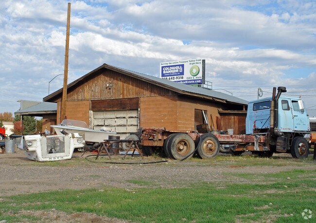
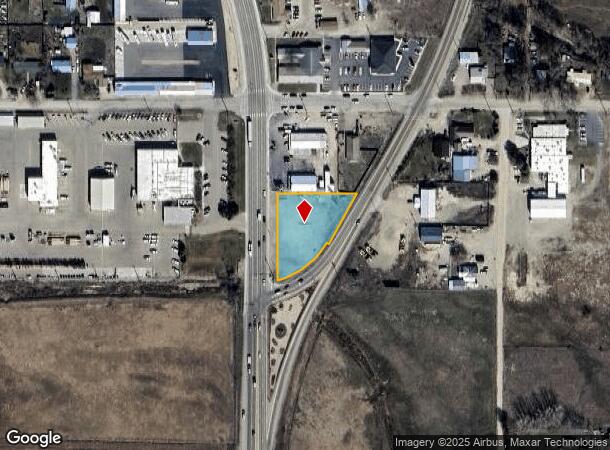
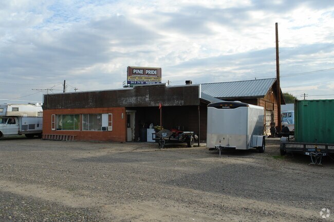
Property Record
1581 S Main St, Payette, ID 83661
NEARBY LISTINGS FOR SALE OR LEASE
Property Detail
1581 S Main St
Ontario, OR-ID
Carpenters
P1100008000E
CARPENTERS SUB TAX 8 LYING W OF HWY IN BLK 8 08N05W03SW
Commercialacreage
Payette
2025
Idaho
2025
0.80 AC
960200
Idaho South Area
2,314 SF
Other Market Areas
DEMOGRAPHICS near 1581 S Main St
1 Mile
3 Mile
5 Mile
2024 Total Population
1,904
20,288
34,369
2029 Population
2,241
23,197
38,277
Pop Growth 2024-2029
+ 17.70%
+ 14.34%
+ 11.37%
Average Age
41
39
39
2024 Total Households
757
7,603
12,796
HH Growth 2024-2029
+ 18.10%
+ 14.73%
+ 11.69%
Median Household Inc
$43,902
$53,836
$55,345
Avg Household Size
2.50
2.60
2.60
2024 Avg HH Vehicles
2.00
2.00
2.00
Median Home Value
$237,500
$220,290
$232,705
Median Year Built
1979
1977
1976
Nearby Places
Map Layers
Map Styles
 Street
 Aerial
- Restaurants
- Banks
- Shops
- Fitness
- Groceries
Nearby Properties
Address
Land Use
TOTAL SIZE
Lot Size
Zoning
Address
Land Use
TOTAL SIZE
Lot Size
Zoning
50.97 AC
O-I2
Address
Land Use
TOTAL SIZE
Lot Size
Zoning
10 SF
6.75 AC
O-PF
Address
Land Use
TOTAL SIZE
Lot Size
Zoning
35.92 AC
Address
Land Use
TOTAL SIZE
Lot Size
Zoning
50.97 AC
O-I2
Address
Land Use
TOTAL SIZE
Lot Size
Zoning
4.96 AC
O-C2
Address
Land Use
TOTAL SIZE
Lot Size
Zoning
197,522 SF
19.72 AC
O-C2
Address
Land Use
TOTAL SIZE
Lot Size
Zoning
71,504 SF
5.94 AC
Address
Land Use
TOTAL SIZE
Lot Size
Zoning
104,456 SF
8.71 AC
O-C2H
Address
Land Use
TOTAL SIZE
Lot Size
Zoning
42,807 SF
11.02 AC
Address
Land Use
TOTAL SIZE
Lot Size
Zoning
1.57 AC
Address
Land Use
TOTAL SIZE
Lot Size
Zoning
21,715 SF
4.94 AC
Address
Land Use
TOTAL SIZE
Lot Size
Zoning
39,162 SF
3.95 AC
Address
Land Use
TOTAL SIZE
Lot Size
Zoning
9.69 AC
INDUSTRIAL
Address
Land Use
TOTAL SIZE
Lot Size
Zoning
141.70 AC
O-I2
Address
Land Use
TOTAL SIZE
Lot Size
Zoning
Address
Land Use
TOTAL SIZE
Lot Size
Zoning
62,348 SF
2.24 AC
O-C2
Address
Land Use
TOTAL SIZE
Lot Size
Zoning
47,605 SF
9.07 AC
O-PF
Address
Land Use
TOTAL SIZE
Lot Size
Zoning
26,855 SF
1.85 AC
Address
Land Use
TOTAL SIZE
Lot Size
Zoning
48,892 SF
5.76 AC
O-C2H
Address
Land Use
TOTAL SIZE
Lot Size
Zoning
38,083 SF
1.37 AC
Address
Land Use
TOTAL SIZE
Lot Size
Zoning
18.67 AC
Address
Land Use
TOTAL SIZE
Lot Size
Zoning
1.53 AC
O-I2
Address
Land Use
TOTAL SIZE
Lot Size
Zoning
1,560 SF
37.06 AC
O-PF
Address
Land Use
TOTAL SIZE
Lot Size
Zoning
41.81 AC
O-I2+
Address
Land Use
TOTAL SIZE
Lot Size
Zoning
13,110 SF
7.54 AC
O-I1
Address
Land Use
TOTAL SIZE
Lot Size
Zoning
1,800 SF
4.09 AC
Address
Land Use
TOTAL SIZE
Lot Size
Zoning
34,363 SF
1.54 AC
O-RM
Address
Land Use
TOTAL SIZE
Lot Size
Zoning
50,829 SF
5.86 AC
O-C2H
Address
Land Use
TOTAL SIZE
Lot Size
Zoning
22,520 SF
4.24 AC
Address
Land Use
TOTAL SIZE
Lot Size
Zoning
23,281 SF
3.44 AC
O-C2H
The World's #1 Commercial Real Estate Marketplace
Connect with us
© 2025 CoStar Group
The information above has been obtained from sources believed reliable. While we do not doubt its accuracy we have not verified it and make no guarantee, warranty or representation about it. It is your responsibility to independently confirm its accuracy and completeness. Any projections, opinions, assumptions, or estimates used are for example only and do not represent the current or future performance of the property. The value of this transaction to you depends on tax and other factors which should be evaluated by your tax, financial, and legal advisors. You and your advisors should conduct a careful, independent investigation of the property to determine to your satisfaction the suitability of the property for your needs.