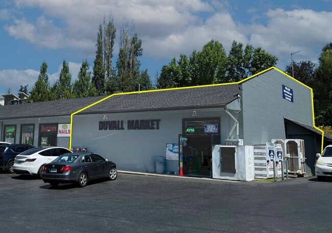
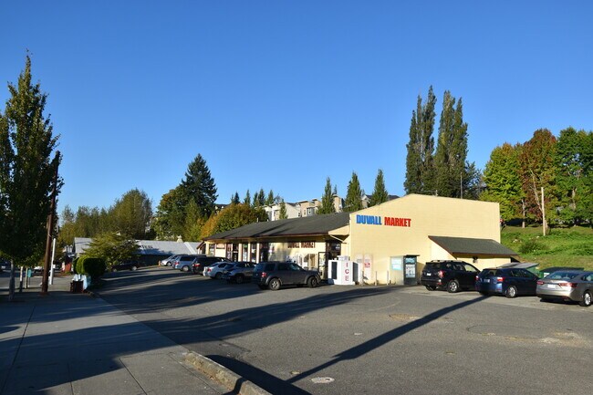
Property Record
15820 Main St Ne, Duvall, WA 98019

NEARBY LISTINGS FOR SALE OR LEASE
Property Detail
15820 Main St Ne
Seattle-Tacoma-Bellevue, WA
Duvall Plat Of Div No. 01
213070-0470
DUVALL PLAT OF DIV # 1 12 LESS S 3 FT 10 IN PLAT BLOCK: 9 PLAT LOT: 12
Storebuilding
King
X
Washington
53033C0401G
12
2025
0.24 AC
2024
E King County
032401
Seattle/Puget Sound
6,744 SF
DEMOGRAPHICS near 15820 Main St Ne
1 Mile
3 Mile
5 Mile
2024 Total Population
4,390
14,616
40,380
2029 Population
4,397
14,616
40,432
Pop Growth 2024-2029
+ 0.16%
0.00%
+ 0.13%
Average Age
37
43
42
2024 Total Households
1,503
5,304
14,263
HH Growth 2024-2029
(0.13%)
(0.21%)
(0.04%)
Median Household Inc
$171,341
$163,659
$172,569
Avg Household Size
2.90
2.70
2.80
2024 Avg HH Vehicles
2.00
2.00
2.00
Median Home Value
$727,206
$813,294
$882,129
Median Year Built
2000
1996
1995
Nearby Places
Map Layers
Map Styles
 Street
 Aerial
- Restaurants
- Banks
- Shops
- Fitness
- Groceries
PUBLIC TRANSPORTATION
AIRPORT
Seattle Paine Field International
DRIVE
WALK
Distance
Seattle Paine Field International
42 min
25.6 mi
Seattle-Tacoma International
DRIVE
WALK
Distance
Seattle-Tacoma International
52 min
34.0 mi
Freight Ports
Port of Everett
DRIVE
WALK
Distance
Port of Everett
39 min
25.6 mi
SALE & LEASE HISTORY
LISTING DATE
SALE/LEASE

Oct 21, 2021
For Lease
Aug 29, 2024
For Lease
Nearby Properties
Address
Land Use
TOTAL SIZE
Lot Size
Zoning
Address
Land Use
TOTAL SIZE
Lot Size
Zoning
93,333 SF
42.85 AC
PF
Address
Land Use
TOTAL SIZE
Lot Size
Zoning
89,407 SF
0.95 AC
LI
Address
Land Use
TOTAL SIZE
Lot Size
Zoning
44,816 SF
5.86 AC
CO
Address
Land Use
TOTAL SIZE
Lot Size
Zoning
41,244 SF
1.50 AC
MT
Address
Land Use
TOTAL SIZE
Lot Size
Zoning
14,272 SF
30 AC
RA5
Address
Land Use
TOTAL SIZE
Lot Size
Zoning
37,864 SF
10.19 AC
PF
Address
Land Use
TOTAL SIZE
Lot Size
Zoning
2,940 SF
7.46 AC
PF
Address
Land Use
TOTAL SIZE
Lot Size
Zoning
4,641 SF
1.50 AC
MT
Address
Land Use
TOTAL SIZE
Lot Size
Zoning
26,000 SF
0.54 AC
MT
Address
Land Use
TOTAL SIZE
Lot Size
Zoning
34,412 SF
5.25 AC
LI
Address
Land Use
TOTAL SIZE
Lot Size
Zoning
22,040 SF
0.26 AC
PF
Address
Land Use
TOTAL SIZE
Lot Size
Zoning
6,307 SF
1.64 AC
CO
Address
Land Use
TOTAL SIZE
Lot Size
Zoning
Address
Land Use
TOTAL SIZE
Lot Size
Zoning
12,177 SF
1.05 AC
R20
Address
Land Use
TOTAL SIZE
Lot Size
Zoning
7,810 SF
0.44 AC
MT
Address
Land Use
TOTAL SIZE
Lot Size
Zoning
12,830 SF
0.50 AC
MT
Address
Land Use
TOTAL SIZE
Lot Size
Zoning
7,312 SF
0.47 AC
UT-1
Address
Land Use
TOTAL SIZE
Lot Size
Zoning
11,300 SF
1.13 AC
LI
Address
Land Use
TOTAL SIZE
Lot Size
Zoning
13,364 SF
0.32 AC
PF
Address
Land Use
TOTAL SIZE
Lot Size
Zoning
8,290 SF
0.26 AC
OT
Address
Land Use
TOTAL SIZE
Lot Size
Zoning
9,818 SF
0.20 AC
OT
Address
Land Use
TOTAL SIZE
Lot Size
Zoning
11,952 SF
0.14 AC
OT
Address
Land Use
TOTAL SIZE
Lot Size
Zoning
1.80 AC
RA5
Address
Land Use
TOTAL SIZE
Lot Size
Zoning
17,136 SF
1.21 AC
MT
Address
Land Use
TOTAL SIZE
Lot Size
Zoning
20,269 SF
12.16 AC
R6
Address
Land Use
TOTAL SIZE
Lot Size
Zoning
11,920 SF
0.15 AC
OT
The World's #1 Commercial Real Estate Marketplace
Connect with us
© 2026 CoStar Group
The information above has been obtained from sources believed reliable. While we do not doubt its accuracy we have not verified it and make no guarantee, warranty or representation about it. It is your responsibility to independently confirm its accuracy and completeness. Any projections, opinions, assumptions, or estimates used are for example only and do not represent the current or future performance of the property. The value of this transaction to you depends on tax and other factors which should be evaluated by your tax, financial, and legal advisors. You and your advisors should conduct a careful, independent investigation of the property to determine to your satisfaction the suitability of the property for your needs.