Property Record
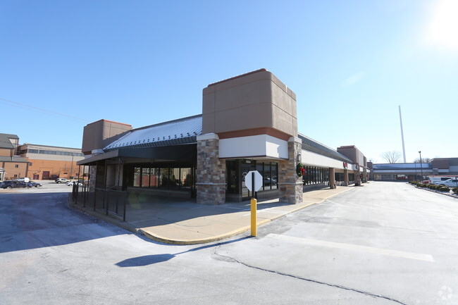
15828 Manchester Rd, Ellisville, MO 63011


NEARBY LISTINGS FOR SALE OR LEASE
Property Detail
15828 Manchester Rd
St. Louis, MO-IL
Captain Benjamin F Hutchinson Lot Pt 25
23T-53-1201
CAPTAIN BENJAMIN F HUTCHINSON LOT PT 25 & CAPTAIN BENJAMIN F HUTCHINSON LOT PT 25 BDY ADJ TRACT PTS A & B BDY ADJ TRACT A
Stripcommercialcenter
St. Louis
X
Missouri
29099C0025F
25
2024
11.10 AC
2025
West County
217943
St. Louis
120,760 SF
DEMOGRAPHICS near 15828 Manchester Rd
1 Mile
3 Mile
5 Mile
2024 Total Population
8,013
65,904
136,604
2029 Population
7,837
64,223
133,482
Pop Growth 2024-2029
(2.20%)
(2.55%)
(2.29%)
Average Age
43
42
42
2024 Total Households
3,211
25,007
52,659
HH Growth 2024-2029
(2.24%)
(2.56%)
(2.29%)
Median Household Inc
$103,472
$120,208
$119,246
Avg Household Size
2.40
2.60
2.60
2024 Avg HH Vehicles
2.00
2.00
2.00
Median Home Value
$314,491
$359,959
$361,556
Median Year Built
1980
1983
1982
Nearby Places
Map Layers
Map Styles
 Street
 Aerial
- Restaurants
- Banks
- Shops
- Fitness
- Groceries
PUBLIC TRANSPORTATION
AIRPORT
St Louis Lambert International
DRIVE
WALK
Distance
St Louis Lambert International
39 min
25.5 mi
SALE & LEASE HISTORY
LISTING DATE
SALE/LEASE

Jan 05, 2018
For Lease
Nearby Properties
Address
Land Use
TOTAL SIZE
Lot Size
Zoning
Address
Land Use
TOTAL SIZE
Lot Size
Zoning
156,253 SF
10.64 AC
87PC
Address
Land Use
TOTAL SIZE
Lot Size
Zoning
70.42 AC
87A
Address
Land Use
TOTAL SIZE
Lot Size
Zoning
51.20 AC
NU
Address
Land Use
TOTAL SIZE
Lot Size
Zoning
403,166 SF
23.17 AC
R4
Address
Land Use
TOTAL SIZE
Lot Size
Zoning
313,104 SF
14.66 AC
MXD
Address
Land Use
TOTAL SIZE
Lot Size
Zoning
138,056 SF
17.42 AC
NU
Address
Land Use
TOTAL SIZE
Lot Size
Zoning
223,598 SF
13.95 AC
93C-1
Address
Land Use
TOTAL SIZE
Lot Size
Zoning
175,448 SF
6.95 AC
Address
Land Use
TOTAL SIZE
Lot Size
Zoning
111,719 SF
9.51 AC
19C-1
Address
Land Use
TOTAL SIZE
Lot Size
Zoning
153,489 SF
13.01 AC
93C-1
Address
Land Use
TOTAL SIZE
Lot Size
Zoning
247,992 SF
5.72 AC
C
Address
Land Use
TOTAL SIZE
Lot Size
Zoning
2,154 SF
13.19 AC
S
Address
Land Use
TOTAL SIZE
Lot Size
Zoning
7,900 SF
31.95 AC
87A
Address
Land Use
TOTAL SIZE
Lot Size
Zoning
23.18 AC
105NU
Address
Land Use
TOTAL SIZE
Lot Size
Zoning
220,288 SF
11.09 AC
93R-4
Address
Land Use
TOTAL SIZE
Lot Size
Zoning
191,316 SF
7.61 AC
R4
Address
Land Use
TOTAL SIZE
Lot Size
Zoning
181,790 SF
16.64 AC
R4
Address
Land Use
TOTAL SIZE
Lot Size
Zoning
164,430 SF
9.85 AC
19C-4
Address
Land Use
TOTAL SIZE
Lot Size
Zoning
128,358 SF
12.01 AC
19C-3
Address
Land Use
TOTAL SIZE
Lot Size
Zoning
115,050 SF
12.46 AC
87C
Address
Land Use
TOTAL SIZE
Lot Size
Zoning
247,511 SF
31.03 AC
19M-1
Address
Land Use
TOTAL SIZE
Lot Size
Zoning
74,614 SF
8.05 AC
93C-1
Address
Land Use
TOTAL SIZE
Lot Size
Zoning
27.05 AC
R1
Address
Land Use
TOTAL SIZE
Lot Size
Zoning
82,686 SF
8.74 AC
C
Address
Land Use
TOTAL SIZE
Lot Size
Zoning
70,267 SF
11.61 AC
19C-3
Address
Land Use
TOTAL SIZE
Lot Size
Zoning
7,250 SF
80.06 AC
R
Address
Land Use
TOTAL SIZE
Lot Size
Zoning
136,009 SF
12.35 AC
93C-1
Address
Land Use
TOTAL SIZE
Lot Size
Zoning
185,087 SF
8 AC
19C-4
Address
Land Use
TOTAL SIZE
Lot Size
Zoning
118,097 SF
14.32 AC
19C-4
The World's #1 Commercial Real Estate Marketplace
Connect with us
© 2026 CoStar Group
The information above has been obtained from sources believed reliable. While we do not doubt its accuracy we have not verified it and make no guarantee, warranty or representation about it. It is your responsibility to independently confirm its accuracy and completeness. Any projections, opinions, assumptions, or estimates used are for example only and do not represent the current or future performance of the property. The value of this transaction to you depends on tax and other factors which should be evaluated by your tax, financial, and legal advisors. You and your advisors should conduct a careful, independent investigation of the property to determine to your satisfaction the suitability of the property for your needs.