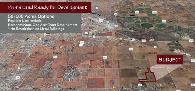
Property Record
1585 E E Fm 1585, Slaton, TX 79364

Property Detail
1585 E E Fm 1585
Lubbock, TX
BLK S SEC 66 AB 470 TR A OF W/2 AC: 40.204
R327226
LUBBOCK
Ranch
Texas
A Areas with a 1% annual chance of flooding and a 26% chance of flooding over the life of a 30-year mortgage.
40.20 AC
2024
Outlying Lubbock County
2025
Lubbock
010601
NEARBY LISTINGS FOR SALE OR LEASE
DEMOGRAPHICS near 1585 E E Fm 1585
1 mile
3 mile
5 mile
2024 Total Population
121
792
7,265
2029 Population
128
841
7,770
Pop Growth 2024-2029
+ 5.79%
+ 6.19%
+ 6.95%
Average Age
42
41
37
2024 Total Households
49
229
2,404
HH Growth 2024-2029
+ 6.12%
+ 6.55%
+ 7.32%
Median Household Inc
$112,500
$75,781
$74,016
Avg Household Size
2.50
2.60
2.70
2024 Avg HH Vehicles
2.00
2.00
2.00
Median Home Value
$406,250
$336,956
$201,957
Median Year Built
1982
1988
1994
Nearby Places
Map Layers
Map Styles
 Street
 Aerial
Transit
 Traffic
 Biking
Places
Listings with unknown addresses are not visible on the map
- Restaurants
- Banks
- Shops
- Fitness
- Groceries
PUBLIC TRANSPORTATION
AIRPORT
Lubbock Preston Smith International
Drive
Walk
Distance
Lubbock Preston Smith International
33 min
20.8 mi
Freight Ports
Tulsa Port Of Catoosa
Drive
Walk
Distance
Tulsa Port Of Catoosa
511 min
473.0 mi
SALE & LEASE HISTORY
LISTING DATE
SALE/LEASE

Jan 21, 2021
For Sale
Nearby Properties
Address
Land Use
TOTAL SIZE
Lot Size
Zoning
Address
Land Use
TOTAL SIZE
Lot Size
Zoning
46,034 SF
14.04 AC
Address
Land Use
TOTAL SIZE
Lot Size
Zoning
62,175 SF
7.09 AC
Address
Land Use
TOTAL SIZE
Lot Size
Zoning
21,079 SF
15.14 AC
Address
Land Use
TOTAL SIZE
Lot Size
Zoning
45,491 SF
10 AC
Address
Land Use
TOTAL SIZE
Lot Size
Zoning
102,822 SF
6.40 AC
Address
Land Use
TOTAL SIZE
Lot Size
Zoning
182,106 SF
63.11 AC
Address
Land Use
TOTAL SIZE
Lot Size
Zoning
21,130 SF
8.94 AC
Address
Land Use
TOTAL SIZE
Lot Size
Zoning
40.51 AC
Address
Land Use
TOTAL SIZE
Lot Size
Zoning
9,680 SF
2.36 AC
Address
Land Use
TOTAL SIZE
Lot Size
Zoning
12,260 SF
9.99 AC
Address
Land Use
TOTAL SIZE
Lot Size
Zoning
56,400 SF
4.24 AC
Address
Land Use
TOTAL SIZE
Lot Size
Zoning
13,375 SF
10 AC
Address
Land Use
TOTAL SIZE
Lot Size
Zoning
43,180 SF
7.31 AC
Address
Land Use
TOTAL SIZE
Lot Size
Zoning
5,800 SF
72.38 AC
Address
Land Use
TOTAL SIZE
Lot Size
Zoning
50,000 SF
10 AC
Address
Land Use
TOTAL SIZE
Lot Size
Zoning
4,749 SF
22.33 AC
Address
Land Use
TOTAL SIZE
Lot Size
Zoning
15,540 SF
5.22 AC
Address
Land Use
TOTAL SIZE
Lot Size
Zoning
16,849 SF
7.94 AC
Address
Land Use
TOTAL SIZE
Lot Size
Zoning
71,589 SF
17.93 AC
Address
Land Use
TOTAL SIZE
Lot Size
Zoning
57,022 SF
102.11 AC
Address
Land Use
TOTAL SIZE
Lot Size
Zoning
9,280 SF
3.36 AC
Address
Land Use
TOTAL SIZE
Lot Size
Zoning
62,402 SF
14.53 AC
Address
Land Use
TOTAL SIZE
Lot Size
Zoning
25,471 SF
29.10 AC
Address
Land Use
TOTAL SIZE
Lot Size
Zoning
302.31 AC
Address
Land Use
TOTAL SIZE
Lot Size
Zoning
15,050 SF
2.03 AC
Address
Land Use
TOTAL SIZE
Lot Size
Zoning
17,721 SF
72.10 AC
Address
Land Use
TOTAL SIZE
Lot Size
Zoning
9,000 SF
1.31 AC
Address
Land Use
TOTAL SIZE
Lot Size
Zoning
12,800 SF
1.24 AC
Address
Land Use
TOTAL SIZE
Lot Size
Zoning
7,000 SF
1.06 AC
Address
Land Use
TOTAL SIZE
Lot Size
Zoning
14,200 SF
1.07 AC
The World's #1 Commercial Real Estate Marketplace
Connect with us
© 2026 CoStar Group
The information above has been obtained from sources believed reliable. While we do not doubt its accuracy we have not verified it and make no guarantee, warranty or representation about it. It is your responsibility to independently confirm its accuracy and completeness. Any projections, opinions, assumptions, or estimates used are for example only and do not represent the current or future performance of the property. The value of this transaction to you depends on tax and other factors which should be evaluated by your tax, financial, and legal advisors. You and your advisors should conduct a careful, independent investigation of the property to determine to your satisfaction the suitability of the property for your needs.