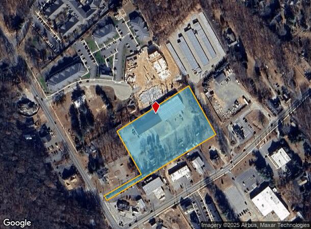
Property Record
1586 Saybrook Rd, Haddam, CT 06438

NEARBY LISTINGS FOR SALE OR LEASE
-
-
View all Haddam listings for sale on LoopNet.com
Property Detail
1586 Saybrook Rd
HADD-000049-000000-000072
Middlesex
Industrialgeneral
Connecticut
X
3.60 AC
09007C0253G
SW Midlsx/Old Saybrk
2025
Hartford
2025
Hartford-West Hartford-East Hartford, CT
590101
DEMOGRAPHICS near 1586 Saybrook Rd
1 Mile
3 Mile
5 Mile
2024 Total Population
791
4,314
15,044
2029 Population
797
4,327
14,983
Pop Growth 2024-2029
+ 0.76%
+ 0.30%
(0.41%)
Average Age
46
46
46
2024 Total Households
323
1,762
6,300
HH Growth 2024-2029
+ 0.62%
+ 0.17%
(0.59%)
Median Household Inc
$127,594
$110,259
$100,890
Avg Household Size
2.40
2.30
2.30
2024 Avg HH Vehicles
2.00
2.00
2.00
Median Home Value
$297,499
$319,739
$323,265
Median Year Built
1970
1969
1969
Nearby Places
Map Layers
Map Styles
 Street
 Aerial
- Restaurants
- Banks
- Shops
- Fitness
- Groceries
PUBLIC TRANSPORTATION
AIRPORT
Tweed/New Haven
DRIVE
WALK
Distance
Tweed/New Haven
54 min
36.6 mi
Freight Ports
Port of New Haven
DRIVE
WALK
Distance
Port of New Haven
54 min
37.2 mi
SALE & LEASE HISTORY
LISTING DATE
SALE/LEASE

Sep 24, 2016
For Sale
Jun 15, 2017
For Sale
Feb 09, 2024
For Sale
Nearby Properties
Address
Land Use
TOTAL SIZE
Lot Size
Zoning
Address
Land Use
TOTAL SIZE
Lot Size
Zoning
544.80 AC
R-2
Address
Land Use
TOTAL SIZE
Lot Size
Zoning
12.29 AC
COMM
Address
Land Use
TOTAL SIZE
Lot Size
Zoning
34,164 SF
2.40 AC
I-1
Address
Land Use
TOTAL SIZE
Lot Size
Zoning
16,008 SF
1.50 AC
C
Address
Land Use
TOTAL SIZE
Lot Size
Zoning
16,804 SF
2.63 AC
COMM
Address
Land Use
TOTAL SIZE
Lot Size
Zoning
19,653 SF
19.89 AC
R2
Address
Land Use
TOTAL SIZE
Lot Size
Zoning
34,574 SF
1.60 AC
COMM
Address
Land Use
TOTAL SIZE
Lot Size
Zoning
14,016 SF
16.03 AC
R-1
Address
Land Use
TOTAL SIZE
Lot Size
Zoning
28,170 SF
19.65 AC
R-2A
Address
Land Use
TOTAL SIZE
Lot Size
Zoning
1,157.55 AC
R-2
Address
Land Use
TOTAL SIZE
Lot Size
Zoning
880 SF
7.64 AC
EHVD
Address
Land Use
TOTAL SIZE
Lot Size
Zoning
22.26 AC
R-1
Address
Land Use
TOTAL SIZE
Lot Size
Zoning
11.06 AC
R1
Address
Land Use
TOTAL SIZE
Lot Size
Zoning
11,472 SF
0.27 AC
EHVD
Address
Land Use
TOTAL SIZE
Lot Size
Zoning
3 AC
COMM
Address
Land Use
TOTAL SIZE
Lot Size
Zoning
6,978 SF
164.08 AC
R-2
Address
Land Use
TOTAL SIZE
Lot Size
Zoning
2.99 AC
IND
Address
Land Use
TOTAL SIZE
Lot Size
Zoning
8,309 SF
2.30 AC
R-2
Address
Land Use
TOTAL SIZE
Lot Size
Zoning
21,905 SF
3.02 AC
C
Address
Land Use
TOTAL SIZE
Lot Size
Zoning
3.20 AC
COMM
Address
Land Use
TOTAL SIZE
Lot Size
Zoning
1,026 SF
46.70 AC
R-2A
Address
Land Use
TOTAL SIZE
Lot Size
Zoning
5.13 AC
I-1
Address
Land Use
TOTAL SIZE
Lot Size
Zoning
13.52 AC
R-2
Address
Land Use
TOTAL SIZE
Lot Size
Zoning
12,599 SF
0.65 AC
EHVD
Address
Land Use
TOTAL SIZE
Lot Size
Zoning
35.65 AC
R2
Address
Land Use
TOTAL SIZE
Lot Size
Zoning
3.44 AC
R-2
Address
Land Use
TOTAL SIZE
Lot Size
Zoning
87.59 AC
R2
Address
Land Use
TOTAL SIZE
Lot Size
Zoning
2.21 AC
COMM
Address
Land Use
TOTAL SIZE
Lot Size
Zoning
6.72 AC
IG3
Address
Land Use
TOTAL SIZE
Lot Size
Zoning
19,824 SF
34.40 AC
I-1
The World's #1 Commercial Real Estate Marketplace
Connect with us
© 2025 CoStar Group
The information above has been obtained from sources believed reliable. While we do not doubt its accuracy we have not verified it and make no guarantee, warranty or representation about it. It is your responsibility to independently confirm its accuracy and completeness. Any projections, opinions, assumptions, or estimates used are for example only and do not represent the current or future performance of the property. The value of this transaction to you depends on tax and other factors which should be evaluated by your tax, financial, and legal advisors. You and your advisors should conduct a careful, independent investigation of the property to determine to your satisfaction the suitability of the property for your needs.