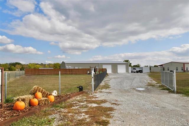
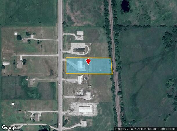
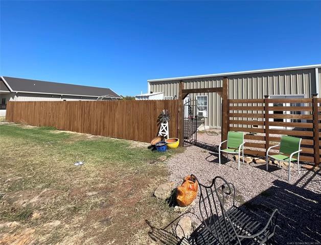
Property Record
1586 Us Highway 77, Ardmore, OK 73401
NEARBY LISTINGS FOR SALE OR LEASE
-
-
View all Ardmore listings for lease on LoopNet.com
Property Detail
1586 Us Highway 77
0000-30-05S-02E-3-009-00
S/2 GOVT LOT 2 LYING W OF WEST ROW OF RAILROAD BEG 329.20 S NW/C S/2 OF GOVT 2; S89.5321E 555.43; S04.3753E 166.77; N89.5321W 569.02; N00.0237E 166.20 TO POB-30 05S 02E
Farmsupplyequipmentretail
Carter
X
Oklahoma
40019C0600C
2.15 AC
2024
Oklahoma East Area
2025
Other Market Areas
892700
Ardmore, OK
3,200 SF
DEMOGRAPHICS near 1586 Us Highway 77
1 Mile
3 Mile
5 Mile
2024 Total Population
88
1,301
7,848
2029 Population
90
1,311
8,035
Pop Growth 2024-2029
+ 2.27%
+ 0.77%
+ 2.38%
Average Age
40
39
39
2024 Total Households
35
488
2,959
HH Growth 2024-2029
+ 2.86%
+ 0.82%
+ 2.37%
Median Household Inc
$47,500
$69,374
$53,679
Avg Household Size
2.40
2.60
2.50
2024 Avg HH Vehicles
2.00
2.00
2.00
Median Home Value
$163,636
$211,154
$181,328
Median Year Built
1982
1981
1975
Nearby Places
Map Layers
Map Styles
 Street
 Aerial
- Restaurants
- Banks
- Shops
- Fitness
- Groceries
PUBLIC TRANSPORTATION
COMMUTER RAIL
Ardmore Amtrak Station (Heartland Flyer - Amtrak)
DRIVE
WALK
Distance
Ardmore Amtrak Station (Heartland Flyer - Amtrak)
11 min
6.6 mi
Freight Ports
Tulsa Port of Inola
DRIVE
WALK
Distance
Tulsa Port of Inola
245 min
210.7 mi
SALE & LEASE HISTORY
LISTING DATE
SALE/LEASE

Apr 04, 2024
For Lease
Nearby Properties
Address
Land Use
TOTAL SIZE
Lot Size
Zoning
Address
Land Use
TOTAL SIZE
Lot Size
Zoning
1,020 SF
34.64 AC
C1
Address
Land Use
TOTAL SIZE
Lot Size
Zoning
408 SF
78.62 AC
C1
Address
Land Use
TOTAL SIZE
Lot Size
Zoning
980 SF
23.12 AC
C1
Address
Land Use
TOTAL SIZE
Lot Size
Zoning
5,571 SF
37.97 AC
C1
Address
Land Use
TOTAL SIZE
Lot Size
Zoning
1,066 SF
3.33 AC
C1
Address
Land Use
TOTAL SIZE
Lot Size
Zoning
3,080 SF
5.17 AC
Address
Land Use
TOTAL SIZE
Lot Size
Zoning
4,240 SF
2.90 AC
C1
Address
Land Use
TOTAL SIZE
Lot Size
Zoning
14,760 SF
1.15 AC
C1
Address
Land Use
TOTAL SIZE
Lot Size
Zoning
4,419 SF
9.50 AC
R1
Address
Land Use
TOTAL SIZE
Lot Size
Zoning
640 SF
2.91 AC
C1
Address
Land Use
TOTAL SIZE
Lot Size
Zoning
130 SF
7 AC
C1
Address
Land Use
TOTAL SIZE
Lot Size
Zoning
356 SF
4.98 AC
C1
Address
Land Use
TOTAL SIZE
Lot Size
Zoning
3,000 SF
6.17 AC
C1
Address
Land Use
TOTAL SIZE
Lot Size
Zoning
5,580 SF
2 AC
R1
Address
Land Use
TOTAL SIZE
Lot Size
Zoning
9,380 SF
29.73 AC
IP
Address
Land Use
TOTAL SIZE
Lot Size
Zoning
647 SF
11.44 AC
C1
Address
Land Use
TOTAL SIZE
Lot Size
Zoning
2,312 SF
4 AC
C1
Address
Land Use
TOTAL SIZE
Lot Size
Zoning
448 SF
3.34 AC
C1
Address
Land Use
TOTAL SIZE
Lot Size
Zoning
357 SF
10 AC
C1
Address
Land Use
TOTAL SIZE
Lot Size
Zoning
12,000 SF
41.76 AC
NP
Address
Land Use
TOTAL SIZE
Lot Size
Zoning
4,560 SF
11.35 AC
C1
Address
Land Use
TOTAL SIZE
Lot Size
Zoning
2,702 SF
1.18 AC
Address
Land Use
TOTAL SIZE
Lot Size
Zoning
11.52 AC
C1
Address
Land Use
TOTAL SIZE
Lot Size
Zoning
2,016 SF
2.98 AC
C1
Address
Land Use
TOTAL SIZE
Lot Size
Zoning
428 SF
5 AC
C1
Address
Land Use
TOTAL SIZE
Lot Size
Zoning
3,964 SF
4.72 AC
C1
Address
Land Use
TOTAL SIZE
Lot Size
Zoning
1,600 SF
10 AC
Address
Land Use
TOTAL SIZE
Lot Size
Zoning
10,818 SF
37.67 AC
C1
Address
Land Use
TOTAL SIZE
Lot Size
Zoning
1,702 SF
1.69 AC
C1
Address
Land Use
TOTAL SIZE
Lot Size
Zoning
4,948 SF
1 AC
The World's #1 Commercial Real Estate Marketplace
Connect with us
© 2026 CoStar Group
The information above has been obtained from sources believed reliable. While we do not doubt its accuracy we have not verified it and make no guarantee, warranty or representation about it. It is your responsibility to independently confirm its accuracy and completeness. Any projections, opinions, assumptions, or estimates used are for example only and do not represent the current or future performance of the property. The value of this transaction to you depends on tax and other factors which should be evaluated by your tax, financial, and legal advisors. You and your advisors should conduct a careful, independent investigation of the property to determine to your satisfaction the suitability of the property for your needs.