Property Record
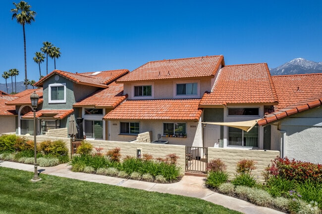
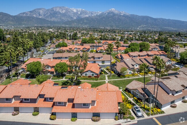
1587 Medinah Cir, Upland, CA 91784

Property Detail
1587 Medinah Cir
Riverside-San Bernardino-Ontario, CA
BEGINNING AT THE NORTHEAST CORNER OF LOT 13 OF TRACT NO. 11631 RECORDED IN BOOK 158 PAGES 53 THROUGH 62 OF MAPS, RECORDS OF THE COUNTY RECORDER OF SAN BERNARDINO COUNTY, STATE OF CALIFORNIA; THENCE ALONG THE WEST LINE OF TANGLEWOOD AVENUE AS DESCRIBE
0202-701-69
SAN BERNARDINO
Apartment
California
B and X Area of moderate flood hazard, usually the area between the limits of the 100-year and 500-year floods.
13
2025
7.58 AC
2025
Rancho Cucamonga
000819
Inland Empire (California)
84,347 SF
NEARBY LISTINGS FOR SALE OR LEASE
DEMOGRAPHICS near 1587 Medinah Cir
1 mile
3 mile
5 mile
2025 Total Population
13,590
144,603
322,960
2030 Population
13,714
145,195
325,094
Pop Growth 2025-2030
+ 0.91%
+ 0.41%
+ 0.66%
Average Age
42
41
39
2025 Total Households
4,641
49,688
107,294
HH Growth 2025-2030
+ 0.84%
+ 0.41%
+ 0.72%
Median Household Inc
$154,496
$105,056
$99,294
Avg Household Size
2.90
2.80
2.90
2025 Avg HH Vehicles
2.00
2.00
2.00
Median Home Value
$758,362
$736,663
$728,253
Median Year Built
1981
1977
1980
Nearby Places
Map Layers
Map Styles
 Street
 Aerial
Transit
 Traffic
 Biking
Places
Listings with unknown addresses are not visible on the map
- Restaurants
- Banks
- Shops
- Fitness
- Groceries
PUBLIC TRANSPORTATION
COMMUTER RAIL
Upland (San Bernardino Line - Southern California Regional Rail Authority (Metrolink))
Drive
Walk
Distance
Upland (San Bernardino Line - Southern California Regional Rail Authority (Metrolink))
7 min
3.4 mi
Rancho Cucamonga (San Bernardino Line - Southern California Regional Rail Authority (Metrolink))
Drive
Walk
Distance
Rancho Cucamonga (San Bernardino Line - Southern California Regional Rail Authority (Metrolink))
11 min
6.4 mi
AIRPORT
Ontario International
Drive
Walk
Distance
Ontario International
11 min
5.8 mi
Freight Ports
Port of Long Beach
Drive
Walk
Distance
Port of Long Beach
69 min
55.3 mi
Nearby Properties
Address
Land Use
TOTAL SIZE
Lot Size
Zoning
Address
Land Use
TOTAL SIZE
Lot Size
Zoning
376,610 SF
25.22 AC
Address
Land Use
TOTAL SIZE
Lot Size
Zoning
174,092 SF
4.42 AC
Address
Land Use
TOTAL SIZE
Lot Size
Zoning
251,645 SF
4.50 AC
Address
Land Use
TOTAL SIZE
Lot Size
Zoning
340,104 SF
8.95 AC
Address
Land Use
TOTAL SIZE
Lot Size
Zoning
249,672 SF
13.80 AC
Address
Land Use
TOTAL SIZE
Lot Size
Zoning
161,555 SF
8.25 AC
Address
Land Use
TOTAL SIZE
Lot Size
Zoning
95,240 SF
8.42 AC
Address
Land Use
TOTAL SIZE
Lot Size
Zoning
99,345 SF
5.15 AC
Address
Land Use
TOTAL SIZE
Lot Size
Zoning
203,092 SF
10 AC
Address
Land Use
TOTAL SIZE
Lot Size
Zoning
63,862 SF
4.77 AC
Address
Land Use
TOTAL SIZE
Lot Size
Zoning
455,226 SF
18.15 AC
Address
Land Use
TOTAL SIZE
Lot Size
Zoning
171,446 SF
10.88 AC
Address
Land Use
TOTAL SIZE
Lot Size
Zoning
54,166 SF
4.60 AC
Address
Land Use
TOTAL SIZE
Lot Size
Zoning
175,624 SF
8.20 AC
Address
Land Use
TOTAL SIZE
Lot Size
Zoning
59,690 SF
3.32 AC
Address
Land Use
TOTAL SIZE
Lot Size
Zoning
87,386 SF
3.90 AC
Address
Land Use
TOTAL SIZE
Lot Size
Zoning
108,000 SF
8.78 AC
Address
Land Use
TOTAL SIZE
Lot Size
Zoning
54,366 SF
4.95 AC
Address
Land Use
TOTAL SIZE
Lot Size
Zoning
139,921 SF
8.72 AC
Address
Land Use
TOTAL SIZE
Lot Size
Zoning
75,755 SF
3.23 AC
Address
Land Use
TOTAL SIZE
Lot Size
Zoning
145,880 SF
9.76 AC
Address
Land Use
TOTAL SIZE
Lot Size
Zoning
56,467 SF
8.78 AC
Address
Land Use
TOTAL SIZE
Lot Size
Zoning
293,200 SF
17.06 AC
Address
Land Use
TOTAL SIZE
Lot Size
Zoning
171,835 SF
10.44 AC
Address
Land Use
TOTAL SIZE
Lot Size
Zoning
122,600 SF
5.94 AC
Address
Land Use
TOTAL SIZE
Lot Size
Zoning
61,791 SF
2.68 AC
Address
Land Use
TOTAL SIZE
Lot Size
Zoning
103,037 SF
3.32 AC
Address
Land Use
TOTAL SIZE
Lot Size
Zoning
159,848 SF
5.30 AC
Address
Land Use
TOTAL SIZE
Lot Size
Zoning
125,452 SF
4.07 AC
Address
Land Use
TOTAL SIZE
Lot Size
Zoning
49,412 SF
2.68 AC
The World's #1 Commercial Real Estate Marketplace
Connect with us
© 2026 CoStar Group
The information above has been obtained from sources believed reliable. While we do not doubt its accuracy we have not verified it and make no guarantee, warranty or representation about it. It is your responsibility to independently confirm its accuracy and completeness. Any projections, opinions, assumptions, or estimates used are for example only and do not represent the current or future performance of the property. The value of this transaction to you depends on tax and other factors which should be evaluated by your tax, financial, and legal advisors. You and your advisors should conduct a careful, independent investigation of the property to determine to your satisfaction the suitability of the property for your needs.