Property Record
15884 State Highway 59, Foley, AL 36535


Save to a Folder
{{folder.Name}}
{{folder.ListingIds.length}} Properties
{{folder.ListingIds.length}} Property
Create a New Folder
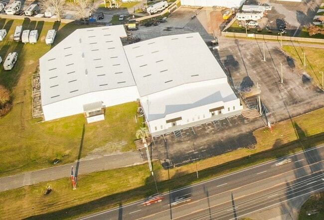
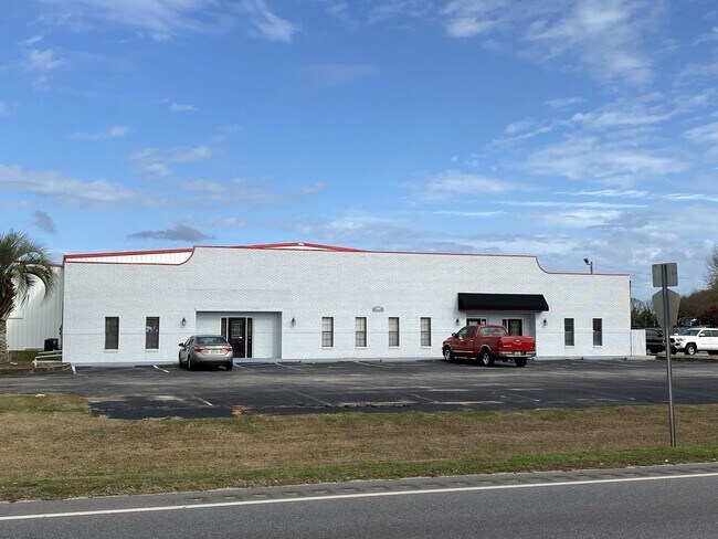
Property Detail
15884 State Highway 59
Daphne-Fairhope-Foley, AL
393.7 X 242'(S) 253.9(D) IRR LOT 3A RESUBDIVISION OF LOT 3 SOUTH 28 SUBDIVISION SLIDE 2789-B; SLIDE 2784-F; SLIDE 2362-D IN T
54-03-08-0-000-002.002
BALDWIN
Autorepair
Alabama
B and X Area of moderate flood hazard, usually the area between the limits of the 100-year and 500-year floods.
3a-3
2025
3.20 AC
2025
Baldwin County
011501
Mobile
38,766 SF
NEARBY LISTINGS FOR SALE OR LEASE
-
-
View all Foley listings for lease on LoopNet.com
DEMOGRAPHICS near 15884 State Highway 59
1 mile
3 mile
5 mile
2025 Total Population
524
8,146
23,323
2030 Population
577
8,912
25,530
Pop Growth 2025-2030
+ 10.11%
+ 9.40%
+ 9.46%
Average Age
44
44
42
2025 Total Households
216
3,246
9,173
HH Growth 2025-2030
+ 10.19%
+ 9.40%
+ 9.46%
Median Household Inc
$66,710
$68,934
$70,334
Avg Household Size
2.40
2.40
2.40
2025 Avg HH Vehicles
2.00
2.00
2.00
Median Home Value
$269,177
$257,534
$250,252
Median Year Built
2003
1998
1998
Nearby Places
Map Layers
Map Styles
 Street
 Aerial
Layers
 Traffic
 Biking
Places
Listings with unknown addresses are not visible on the map
- Restaurants
- Banks
- Shops
- Fitness
- Groceries
PUBLIC TRANSPORTATION
AIRPORT
Pensacola International
Drive
Walk
Distance
Pensacola International
60 min
35.7 mi
Mobile International
Drive
Walk
Distance
Mobile International
51 min
37.1 mi
Freight Ports
Port of Mobile
Drive
Walk
Distance
Port of Mobile
46 min
33.7 mi
SALE & LEASE HISTORY
LISTING DATE
SALE/LEASE

May 12, 2025
For Lease
Nearby Properties
Address
Land Use
TOTAL SIZE
Lot Size
Zoning
Address
Land Use
TOTAL SIZE
Lot Size
Zoning
167,962 SF
11 AC
Address
Land Use
TOTAL SIZE
Lot Size
Zoning
105,000 SF
81 AC
Address
Land Use
TOTAL SIZE
Lot Size
Zoning
64,091 SF
13 AC
Address
Land Use
TOTAL SIZE
Lot Size
Zoning
1,125 SF
19 AC
Address
Land Use
TOTAL SIZE
Lot Size
Zoning
57,431 SF
15 AC
Address
Land Use
TOTAL SIZE
Lot Size
Zoning
26,025 SF
3.95 AC
Address
Land Use
TOTAL SIZE
Lot Size
Zoning
28,002 SF
0.89 AC
Address
Land Use
TOTAL SIZE
Lot Size
Zoning
28,590 SF
2.86 AC
Address
Land Use
TOTAL SIZE
Lot Size
Zoning
14,934 SF
9.30 AC
Address
Land Use
TOTAL SIZE
Lot Size
Zoning
42,337 SF
6.60 AC
Address
Land Use
TOTAL SIZE
Lot Size
Zoning
3,404 SF
19 AC
Address
Land Use
TOTAL SIZE
Lot Size
Zoning
6,072 SF
4.70 AC
Address
Land Use
TOTAL SIZE
Lot Size
Zoning
44,752 SF
4.26 AC
Address
Land Use
TOTAL SIZE
Lot Size
Zoning
8,080 SF
5 AC
Address
Land Use
TOTAL SIZE
Lot Size
Zoning
43,362 SF
5 AC
Address
Land Use
TOTAL SIZE
Lot Size
Zoning
42,517 SF
6 AC
Address
Land Use
TOTAL SIZE
Lot Size
Zoning
30,490 SF
4.51 AC
Address
Land Use
TOTAL SIZE
Lot Size
Zoning
45,100 SF
15 AC
Address
Land Use
TOTAL SIZE
Lot Size
Zoning
1,400 SF
5.50 AC
Address
Land Use
TOTAL SIZE
Lot Size
Zoning
11,356 SF
0.69 AC
Address
Land Use
TOTAL SIZE
Lot Size
Zoning
14,592 SF
3.77 AC
Address
Land Use
TOTAL SIZE
Lot Size
Zoning
5,688 SF
98 AC
Address
Land Use
TOTAL SIZE
Lot Size
Zoning
19,820 SF
1.30 AC
Address
Land Use
TOTAL SIZE
Lot Size
Zoning
13,638 SF
2.26 AC
Address
Land Use
TOTAL SIZE
Lot Size
Zoning
9.20 AC
Address
Land Use
TOTAL SIZE
Lot Size
Zoning
3,715 SF
Address
Land Use
TOTAL SIZE
Lot Size
Zoning
35,536 SF
5.20 AC
Address
Land Use
TOTAL SIZE
Lot Size
Zoning
7,987 SF
57 AC
Address
Land Use
TOTAL SIZE
Lot Size
Zoning
4,597 SF
7.40 AC
Address
Land Use
TOTAL SIZE
Lot Size
Zoning
35,954 SF
1.35 AC
The World's #1 Commercial Real Estate Marketplace
Connect with us
© 2026 CoStar Group
The information above has been obtained from sources believed reliable. While we do not doubt its accuracy we have not verified it and make no guarantee, warranty or representation about it. It is your responsibility to independently confirm its accuracy and completeness. Any projections, opinions, assumptions, or estimates used are for example only and do not represent the current or future performance of the property. The value of this transaction to you depends on tax and other factors which should be evaluated by your tax, financial, and legal advisors. You and your advisors should conduct a careful, independent investigation of the property to determine to your satisfaction the suitability of the property for your needs.