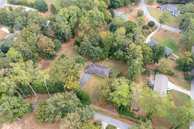
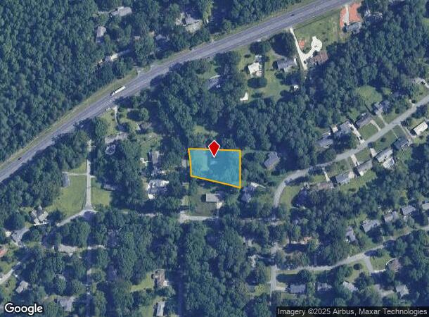
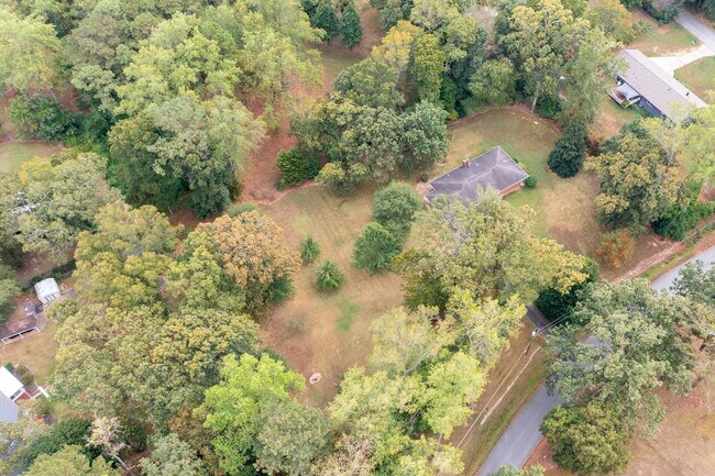
Property Record
1589 Hammond Woods Cir Sw, Marietta, GA 30008
This Property Is For Sale
NEARBY LISTINGS FOR SALE OR LEASE
Property Detail
1589 Hammond Woods Cir Sw
Atlanta-Sandy Springs-Roswell, GA
Hammond Woods
19-0331-0-011-0
Cobb
Sfr
Georgia
X
0.33 AC
13067C0112G
Kennesaw/Town Center
1,312 SF
Atlanta
DEMOGRAPHICS near 1589 Hammond Woods Cir Sw
1 Mile
3 Mile
5 Mile
2024 Total Population
8,693
83,730
187,736
2029 Population
8,932
85,966
193,559
Pop Growth 2024-2029
+ 2.75%
+ 2.67%
+ 3.10%
Average Age
38
38
39
2024 Total Households
2,691
29,624
68,268
HH Growth 2024-2029
+ 3.23%
+ 2.76%
+ 3.18%
Median Household Inc
$89,962
$83,271
$89,414
Avg Household Size
2.70
2.70
2.60
2024 Avg HH Vehicles
2.00
2.00
2.00
Median Home Value
$374,626
$372,339
$411,376
Median Year Built
1983
1984
1986
Nearby Places
- Restaurants
- Banks
- Shops
- Fitness
- Groceries
PUBLIC TRANSPORTATION
AIRPORT
Hartsfield - Jackson Atlanta International
DRIVE
WALK
Distance
Hartsfield - Jackson Atlanta International
46 min
30.6 mi
Nearby Properties
Address
Land Use
TOTAL SIZE
Lot Size
Zoning
Address
Land Use
TOTAL SIZE
Lot Size
Zoning
488,748 SF
32.28 AC
RM-12
Address
Land Use
TOTAL SIZE
Lot Size
Zoning
285,190 SF
25.16 AC
RM-12
Address
Land Use
TOTAL SIZE
Lot Size
Zoning
225,315 SF
17.10 AC
RM-12
Address
Land Use
TOTAL SIZE
Lot Size
Zoning
236,808 SF
29.38 AC
PRD MF
Address
Land Use
TOTAL SIZE
Lot Size
Zoning
222,906 SF
18.96 AC
RM-12
Address
Land Use
TOTAL SIZE
Lot Size
Zoning
148,612 SF
12.65 AC
RM-12
Address
Land Use
TOTAL SIZE
Lot Size
Zoning
176,350 SF
19.56 AC
PRD MF
Address
Land Use
TOTAL SIZE
Lot Size
Zoning
345,192 SF
22.67 AC
RM-12
Address
Land Use
TOTAL SIZE
Lot Size
Zoning
187,972 SF
11.94 AC
RM-12
Address
Land Use
TOTAL SIZE
Lot Size
Zoning
213,318 SF
19.28 AC
PRD MF
Address
Land Use
TOTAL SIZE
Lot Size
Zoning
180,508 SF
21.88 AC
RM-8
Address
Land Use
TOTAL SIZE
Lot Size
Zoning
217,980 SF
12.61 AC
PRD MF
Address
Land Use
TOTAL SIZE
Lot Size
Zoning
289,582 SF
21.01 AC
RM-12
Address
Land Use
TOTAL SIZE
Lot Size
Zoning
133,813 SF
10 AC
RM-12
Address
Land Use
TOTAL SIZE
Lot Size
Zoning
145,185 SF
13.52 AC
RM-12
Address
Land Use
TOTAL SIZE
Lot Size
Zoning
77,699 SF
3.84 AC
O&I/WS
Address
Land Use
TOTAL SIZE
Lot Size
Zoning
112,766 SF
7.94 AC
RM-12
Address
Land Use
TOTAL SIZE
Lot Size
Zoning
161,927 SF
7.95 AC
OI
Address
Land Use
TOTAL SIZE
Lot Size
Zoning
113,652 SF
9.40 AC
RM-12
Address
Land Use
TOTAL SIZE
Lot Size
Zoning
131,802 SF
4.76 AC
RM-12
Address
Land Use
TOTAL SIZE
Lot Size
Zoning
105,892 SF
14.07 AC
NRC/WS
Address
Land Use
TOTAL SIZE
Lot Size
Zoning
74,875 SF
6.36 AC
RM-12
Address
Land Use
TOTAL SIZE
Lot Size
Zoning
128,856 SF
8.31 AC
GC
Address
Land Use
TOTAL SIZE
Lot Size
Zoning
126,108 SF
7.71 AC
PRD MF
Address
Land Use
TOTAL SIZE
Lot Size
Zoning
80,552 SF
10.94 AC
GC/WS
Address
Land Use
TOTAL SIZE
Lot Size
Zoning
74,628 SF
7.90 AC
RM-12
Address
Land Use
TOTAL SIZE
Lot Size
Zoning
93,128 SF
9.45 AC
CRC
Address
Land Use
TOTAL SIZE
Lot Size
Zoning
7,095 SF
7.93 AC
OI
Address
Land Use
TOTAL SIZE
Lot Size
Zoning
94,099 SF
8 AC
RM-12
Address
Land Use
TOTAL SIZE
Lot Size
Zoning
64,980 SF
5.07 AC
RM-12/WS
The World's #1 Commercial Real Estate Marketplace
Connect with us
© 2025 CoStar Group
The information above has been obtained from sources believed reliable. While we do not doubt its accuracy we have not verified it and make no guarantee, warranty or representation about it. It is your responsibility to independently confirm its accuracy and completeness. Any projections, opinions, assumptions, or estimates used are for example only and do not represent the current or future performance of the property. The value of this transaction to you depends on tax and other factors which should be evaluated by your tax, financial, and legal advisors. You and your advisors should conduct a careful, independent investigation of the property to determine to your satisfaction the suitability of the property for your needs.