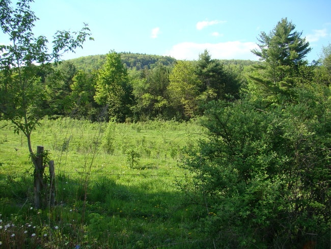
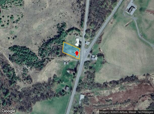
Property Record
1589 Nys Route 9N, Ticonderoga, NY 12883
NEARBY LISTINGS FOR SALE OR LEASE
-
-
View all Ticonderoga listings for sale on LoopNet.com
Property Detail
1589 Nys Route 9N
Other Market Areas
A MCINTOSH PAT
154800-139-002-0002-019-000-0000
Essex
Miscresidentialimprovement
New York
2024
19.000
2024
0.40 AC
961201
Upstate New York Area
DEMOGRAPHICS near 1589 Nys Route 9N
1 Mile
3 Mile
5 Mile
2024 Total Population
253
2,503
6,061
2029 Population
253
2,480
6,073
Pop Growth 2024-2029
0.00%
(0.92%)
+ 0.20%
Average Age
47
44
44
2024 Total Households
107
1,041
2,505
HH Growth 2024-2029
0.00%
(1.15%)
0.00%
Median Household Inc
$71,999
$65,054
$59,760
Avg Household Size
2.30
2.20
2.30
2024 Avg HH Vehicles
2.00
2.00
2.00
Median Home Value
$257,142
$167,073
$162,815
Median Year Built
1974
1949
1967
Nearby Places
- Restaurants
- Banks
- Shops
- Fitness
- Groceries
PUBLIC TRANSPORTATION
COMMUTER RAIL
Ticonderoga Amtrak (Adirondack - Amtrak)
DRIVE
WALK
Distance
Ticonderoga Amtrak (Adirondack - Amtrak)
7 min
4.9 mi
Freight Ports
Albany, NY Port
DRIVE
WALK
Distance
Albany, NY Port
145 min
102.3 mi
Nearby Properties
Address
Land Use
TOTAL SIZE
Lot Size
Zoning
Address
Land Use
TOTAL SIZE
Lot Size
Zoning
242,734 SF
531.30 AC
06 - INDUS
Address
Land Use
TOTAL SIZE
Lot Size
Zoning
04 - FARM
Address
Land Use
TOTAL SIZE
Lot Size
Zoning
0.01 AC
01 - NOT Z
Address
Land Use
TOTAL SIZE
Lot Size
Zoning
29,031 SF
10.47 AC
07 - MIXED
Address
Land Use
TOTAL SIZE
Lot Size
Zoning
115,411 SF
19.45 AC
05 - COMME
Address
Land Use
TOTAL SIZE
Lot Size
Zoning
124,051 SF
25.53 AC
07 - MIXED
Address
Land Use
TOTAL SIZE
Lot Size
Zoning
7,809 SF
3.70 AC
07 - MIXED
Address
Land Use
TOTAL SIZE
Lot Size
Zoning
0.76 AC
05 - COMME
Address
Land Use
TOTAL SIZE
Lot Size
Zoning
40,367 SF
4.40 AC
07 - MIXED
Address
Land Use
TOTAL SIZE
Lot Size
Zoning
Address
Land Use
TOTAL SIZE
Lot Size
Zoning
28,980 SF
0.01 AC
07 - MIXED
Address
Land Use
TOTAL SIZE
Lot Size
Zoning
17,988 SF
5.92 AC
07 - MIXED
Address
Land Use
TOTAL SIZE
Lot Size
Zoning
2,480 SF
24.73 AC
07 - MIXED
Address
Land Use
TOTAL SIZE
Lot Size
Zoning
6,674 SF
0.78 AC
05 - COMME
Address
Land Use
TOTAL SIZE
Lot Size
Zoning
3.40 AC
01 - NOT Z
Address
Land Use
TOTAL SIZE
Lot Size
Zoning
13,896 SF
2 AC
07 - MIXED
Address
Land Use
TOTAL SIZE
Lot Size
Zoning
11,536 SF
6.50 AC
07 - MIXED
Address
Land Use
TOTAL SIZE
Lot Size
Zoning
10.80 AC
02 - SINGL
Address
Land Use
TOTAL SIZE
Lot Size
Zoning
13,596 SF
1.98 AC
07 - MIXED
Address
Land Use
TOTAL SIZE
Lot Size
Zoning
4.30 AC
07 - MIXED
Address
Land Use
TOTAL SIZE
Lot Size
Zoning
6,966 SF
2.20 AC
07 - MIXED
Address
Land Use
TOTAL SIZE
Lot Size
Zoning
3,975 SF
1.50 AC
07 - MIXED
Address
Land Use
TOTAL SIZE
Lot Size
Zoning
33,840 SF
6 AC
07 - MIXED
Address
Land Use
TOTAL SIZE
Lot Size
Zoning
15,643 SF
2.83 AC
05 - COMME
Address
Land Use
TOTAL SIZE
Lot Size
Zoning
33,980 SF
4.90 AC
05 - COMME
Address
Land Use
TOTAL SIZE
Lot Size
Zoning
17,372 SF
2.03 AC
07 - MIXED
Address
Land Use
TOTAL SIZE
Lot Size
Zoning
0.01 AC
07 - MIXED
Address
Land Use
TOTAL SIZE
Lot Size
Zoning
3,739 SF
2.10 AC
05 - COMME
Address
Land Use
TOTAL SIZE
Lot Size
Zoning
9,660 SF
5.80 AC
07 - MIXED
Address
Land Use
TOTAL SIZE
Lot Size
Zoning
0.01 AC
06 - INDUS
The World's #1 Commercial Real Estate Marketplace
Connect with us
© 2025 CoStar Group
The information above has been obtained from sources believed reliable. While we do not doubt its accuracy we have not verified it and make no guarantee, warranty or representation about it. It is your responsibility to independently confirm its accuracy and completeness. Any projections, opinions, assumptions, or estimates used are for example only and do not represent the current or future performance of the property. The value of this transaction to you depends on tax and other factors which should be evaluated by your tax, financial, and legal advisors. You and your advisors should conduct a careful, independent investigation of the property to determine to your satisfaction the suitability of the property for your needs.